Maps of Bavaria

Königreich Bayern
1 : 1284000 Bavorsko (Německo) Tranquillo Mollo
Königreich Bayern
1 : 1240000 Bavorsko (Německo) Mollo, Tranquillo bey Tranquillo Mollo
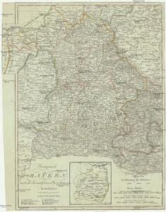
CHARTE vom KÖNIGREICHE BAYERN
Bavorsko (Německo)
Charte vom Königreiche Bayern
Bavorsko (Německo)
Das Königreich Baiern
1 : 780000 Bavorsko (Německo) Dirwald, Joseph Mannert, Conrad T. Mollo
[Atlas zur Geschichte von Bayern] : VII. Das Königreich Bayern nach seinen gegenwärtigen Bestandtheilen mit allen Gebiets-Veränderungen von 1801 bis 1816
K. v. Spruner W. Hase sc. Weimar [Gotha : Perthes]
Haupt-Dreiecknetz für das Königreich Bayern
1 : 1000000 Stiglmayer Contur Obernetter Schrift [gravirt] [S.l.] : [s.n.]
Königreich Baiern nach der neuesten Begrenzung
1 : 700000 Bavorsko (Německo) Mollo, Tranquillo T. Mollo
Königreich Baiern nach der neuesten Begrenzung
1 : 700000 Bavorsko (Německo) Mollo, Tranquillo T. Mollo
Charte vom Königreiche Bayern
1 : 1040000 Bavorsko (Německo) Güssefeld, Franz L. Ehnlich, I. F. C. im Verlag des Geograph. Instituts
Karte vom Königreich Baiern
1 : 1100000 Bavorsko (Německo) in A.G. Schneider u. Weigels k. priv. Kunst- u. Landkartenhandlung
[Atlas zur Geschichte von Bayern] : IV. Die Herzogthümer Baiern, Franken, und ein Theil von Alemannien im XII & XIII Jahrhundert nach erblichen Grafschaften & Gebieten getheilt
K. v. Spruner [Gotha : Perthes]
[Atlas zur Geschichte von Bayern] : II. Die Gauen von Bojoaria, Franconia, und eines Theils von Alemannia vom VIIIten bis in’s XIte Jahrhundert
K. v. Spruner [Gotha : Perthes]
Geschäfts-Uebersichtskarte des Steuer-Katasters bis zum Schlusse des Jahres 18..
1 : 800000 K. Stiglmayer Contur gravirt J. Obernetter Schrift gravirt [S.l.] : [s.n.]
Chur-Bayern im Jahr 1804
1 : 1083000 Bavorsko (Německo) Herdegen, J. C. F. Leizel, Balthasar Friedrich J.L.C. Rheinwald
Les cercles de Souabe et de Baviere
1 : 1740000 Bavorsko (Německo) Bonne, Rigobert André
Souabe, Baviere.
1 : 2900000 Clouet, J. B. L. (Jean-Baptiste Louis), b. 1730
Charte vom Königreiche Bayern
Bavorsko (Německo) Streit, Friedrich Wilhelm
Chur-Bayern im Jahr 1802
1 Karte : Kupferdruck ; 39 x 43 cm Rheinwald; Herdegen; Leizel s.n.

Das Königreich Baiern nach Mannert und andern vorzüglichen Hülfsmitteln
1 : 690000 Bavorsko (Německo) Dirwald, Joseph Mannert, Conrad T. Mollo
Composite: Bayern.
1 : 650000 Radefeld, Carl Christian Franz, 1788-1874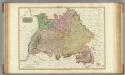
Germany south of the Mayn.
1 : 885000 Pinkerton, John, 1758-1826
[Koenigreich Baiern, Würtemberg u. Baden]
Neuester Schul-Atlas Walch, Johann im Verlag bei Joh. Walch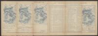
Suevia Et Bavaria XI. Nova Tabula. [Karte], in: Claud. Ptolemaeus. Geographia lat. cum mappis [...], S. 380.
1 Karte aus Atlas Münster, Sebastian [und Ptolemaeus, Claudius]
Karte vom Koenigreich Baiern in Kreise eingetheilt
Bavorsko (Německo) Klipstein, A. Walch, Johann bei Joh. Walch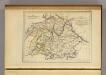
La Baviere, le Wurtemberg, et le Gr. Duche de Bade
1 : 2000000 Malte-Brun, Conrad, 1775-1826
Suevia Et Bavaria XI. Nova Tabula. [Karte], in: Geographia universalis vetus et nova complectens Claudii Ptolemaei Alexandrini enarrationis libros VIII, S. 329.
1 Karte aus Atlas Münster, Sebastian [und Ptolemaeus, Claudius]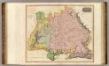
Germany S. of Mayne.
1 : 860000 Thomson, John