Maps of Bavaria

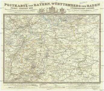
Postkarte von Bayern, Würtemberg und Baden nebst Theilen der angrenzenden Laender
Bavorsko (Německo) Loehle, Franz Franz Loehle
Straßen im Königreich Bayern 1848
Bayern Straßennetz Kunz, Andreas ; Treiling, Thomas
Les cercles de Souabe et de Baviere
1 : 1740000 Bavorsko (Německo) Bonne, Rigobert André
La Baviere, le Wurtemberg, et le Gr. Duche de Bade
1 : 2000000 Malte-Brun, Conrad, 1775-1826
Suevia Et Bavaria XI. Nova Tabula. [Karte], in: Claud. Ptolemaeus. Geographia lat. cum mappis [...], S. 380.
1 Karte aus Atlas Münster, Sebastian [und Ptolemaeus, Claudius]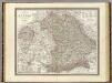
Bayern.
1 : 850000 Weiland, C. F. (Carl Ferdinand), d. 1847
Königreich Bayern Bezirksämter 1862
Bayern Bezirksamt Kunz, Andreas ; Johnen, Bettina ; Moeschl, Joachim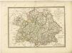

Königreich Bayern Kreisunmittelbare Städte 1862
Bayern Kreisfreie Stadt Kunz, Andreas ; Johnen, Bettina ; Moeschl, Joachim
Suevia Et Bavaria XII. Nova Tabula. [Karte], in: Claud. Ptolemaeus. Geographia lat. cum mappis [...], S. 383.
1 Karte aus Atlas Münster, Sebastian [und Ptolemaeus, Claudius]
Suevia Et Bavaria XI. Nova Tabula. [Karte], in: Geographia universalis vetus et nova complectens Claudii Ptolemaei Alexandrini enarrationis libros VIII, S. 329.
1 Karte aus Atlas Münster, Sebastian [und Ptolemaeus, Claudius]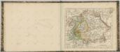

Post- und Reise- Karte vom Bayern und den angrenzenden Ländern und Ländertheilen mit besonderer Bezugnahme auf die schon bestehenden und projektirten Eisenbahnen ausgedehnt bis Basel, Düsseldorf, Dresden, Prag, Linz, Gastein, Insbruck und Bodensee, mit Entfernungs-Angabe der Poststationen
1 : 1100000 Bavorsko (Německo) Obernetter, Johann Baptist Verlag von Mey & Widmayer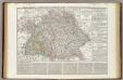
Regni di Baviera, Wurttemberg, Baden, Principati Prussiani.
1 : 2200000 Wieland, C. F.
Neueste Karte von Bayern Würtemberg, Baden und Hohenzollern
Grosser Hand-Atlas über alle Theile der Erde in 170 Karten Meyer, J. Verlag des Bibliographischen Instituts
Das Konigreich Bayern
1 : 850000 Weiland, C.F.
Bayern.
1 : 1390000 Flemming, Carl
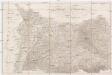
Kriegs Schauplatz vom Jahr 1796 in Deutschland
1 : 860000 Německo jižní Roßenberg Reiller, Fr.
[Koenigreich Baiern, Würtemberg u. Baden]
Neuester Schul-Atlas Walch, Johann im Verlag bei Joh. Walch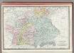
Germany Southern Portion.
1 : 1430000 Rand McNally and Company
Baiern, Wurtemberg, Baden u. Hohenzollern.
1 : 980000 Streit, F. W.
Germany Southern.
1 : 1000000 Hall, S. (Sidney)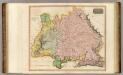
Germany S. of Mayne.
1 : 860000 Thomson, John
Südwestliches Deutschland
Neuer Handatlas über alle Theile der Erde Kiepert, Heinrich Verlag von Dietrich Reimer
[Neuer Atlas der ganzen Erde nach den neuesten Bestimmungen ... : XVII.] Die Königreiche Baiern u. Würtemberg, das Grossherzogthum Baden und die Fürstl. Hohenzollernschen Laender
Entworfen und gezeichnet von Dr. F.W. Streit H. Leutemann sc. Leipzig : J.C. Hinrichssche Buchhandlung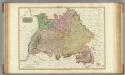
Germany south of the Mayn.
1 : 885000 Pinkerton, John, 1758-1826
Baden, Würtemberg, Baiern
Schul-Atlas in 36 Karten Völter, Daniel Verlag der J.M. Dannheimer'schen Buchhandlung
Chur-Bayern im Jahr 1802
1 Karte : Kupferdruck ; 39 x 43 cm Rheinwald; Herdegen; Leizel s.n.
Southern Germany.
1 : 1710720 Fullarton, A. & Co.