Maps of Camden

Insurance Plan of London North West District Vol. C: sheet 28
1 : 480 This detailed 1900 plan of London is one of a series of thirteen sheets in an atlas originally produced to aid insurance companies in assessing fire risks. The building footprints, their use (commercial, residential, educational, etc.), the number of floors and the height of the building, as well as construction materials (and thus risk of burning) and special fire hazards (chemicals, kilns, ovens) were documented in order to estimate premiums. Names of individual businesses, property lines, and addresses were also often recorded. Together these maps provide a rich historical shapshot of the commercial activity and urban landscape of towns and cities at the time. The British Library holds a comprehensive collection of fire insurance plans produced by the London-based firm Charles E. Goad Ltd. dating back to 1885. These plans were made for most important towns and cities of the British Isles at the scales of 1:480 (1 inch to 40 feet), as well as many foreign towns at 1:600 (1 inch to 50 feet). Chas E Goad Limited Chas E Goad Limited
Insurance Plan of London North West District Vol. C: sheet 29
1 : 480 This detailed 1900 plan of London is one of a series of thirteen sheets in an atlas originally produced to aid insurance companies in assessing fire risks. The building footprints, their use (commercial, residential, educational, etc.), the number of floors and the height of the building, as well as construction materials (and thus risk of burning) and special fire hazards (chemicals, kilns, ovens) were documented in order to estimate premiums. Names of individual businesses, property lines, and addresses were also often recorded. Together these maps provide a rich historical shapshot of the commercial activity and urban landscape of towns and cities at the time. The British Library holds a comprehensive collection of fire insurance plans produced by the London-based firm Charles E. Goad Ltd. dating back to 1885. These plans were made for most important towns and cities of the British Isles at the scales of 1:480 (1 inch to 40 feet), as well as many foreign towns at 1:600 (1 inch to 50 feet). Chas E Goad Limited Chas E Goad Limited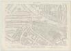
London VII.11 - OS London Town Plan
1 : 1056 Topographic maps Ordnance Survey Ordnance Survey
Plan of the Estate in the vicinity of THE REGENT'S PARK &c. being a portion of the FREEHOLD GROUND RENTS OF THE LORD SOUTHAMPTON
1 : 2004 The title of this plan appears at top left, with compass at bottom centre and scale bar at bottom right. Produced for the sale at auction of the estate in 1840, the plan shows lots numbered for reference, along with the nearby Regent's Canal and the land being developed by the Birmingham and London Railway Company. Madeley
London (1915- Numbered sheets) V.1 (includes: Hampstead; St Pancras) - 25 Inch Map
1 : 2500 Topographic maps Ordnance Survey Ordnance Survey
London (First Editions c1850s) XVI (includes: Hampstead; St Pancras) - 25 Inch Map
1 : 2500 Topographic maps Ordnance Survey Ordnance Survey
THE REGENT'S PARK
1 : 4800 This plan was commissioned by the House of Commons and issued as a supplement to the Wood, Forests and Land Revenues report. The plan's title and imprint are at top right, with a scale bar and key at bottom right. The part of the park to be opened to the public is shown in pale yellow. The grounds of the Zoological Society and the Royal Botanic Society are shown in pink. The areas to be fenced off to protect the privacy of the local residents are shown in dark green. The land to the north of the park recently acquired by Eton College is shown in pale green, and that acquired by Lord Southampton, in pink. Basire, James
PLAN OF THE HAMLET OF KENTISH TOWN and its VICINITY 45 A
1 : 4572 The title and compass of this plan feature at top right, with scale bar and key at bottom right. The boundaries of the Gloucester Palace District and Holmes Estate are outlined in red and green respectively. The development of Kentish Town as a predominantly middle-class residential suburb began in the 1840s and the area lost the rural charm that had, along with its many inns and public houses, made it a popular destination for day trips from London.
A PLAN for the improvements of a FREEHOLD ESTATE call'd ST. IOHN'S WOOD situated in the Parishes of MARYLEBONE & HAMPSTEAD propos'd by Spurrier & Phipps
1 : 7380 The title of this plan of proposed residential developments at St. John's Wood, appears in a tablet at bottom left. A key to the dimensions of lots appears in a tablet at bottom right, with scale noted at the foot of the plate. The revolutionary layout of the estate included a grand circus (never built) surrounded by semi-detatched properties. Spurrier & Phipps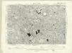
London VII.NW - OS Six-Inch Map
1 : 10560 Topographic maps Ordnance Survey Ordnance Survey
PLAN of the several Freehold Estates situated on the North side of the New Road within the Parish of St. Mary-le-bone and Parts of Hampstead and St. Pancras in the County of Middlesex
1 : 1584 This is Crace's own copy of an 18th-Century plan of the estates north of the New Road at Marylebone. The title and scale bar feature at bottom left, with compass at top centre, and descriptive notes at top left and down the right margin of the sheet. Outline colour marks the boundaries of estates and a single black line those of fields within the estate. The plan also reports the names of landlords and tenant occupiers, with key to the dimensions of each field and estate in a table above the plan. Jones, John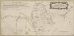
A Plan of the New Intended Road from Paddington to Islington.

Charles Booth's descriptive map of London poverty 1889
Charles Booth
PLAN OF THE PARISH OF ST. MARYLEBONE with the Improvements proposed ON THE MARYLEBONE PARK ESTATE WITH THE CONTIGUOUS PARTS of the Parish of St. Pancras
1 : 5333 Plan of the Parish of St. Marylebone with title at bottom left and explanatory note at bottom right describing proposals for building houses and gardens on land belonging to the Crown along the New Road. White, John
London NW.
1 : 15840 Stanford, Edward
Insurance Plan of London Vol. xi: Key Plan 1
1 : 3600 This "key plan" indicates coverage of the Goad 1891 series of fire insurance maps of London that were originally produced to aid insurance companies in assessing fire risks. The building footprints, their use (commercial, residential, educational, etc.), the number of floors and the height of the building, as well as construction materials (and thus risk of burning) and special fire hazards (chemicals, kilns, ovens) were documented in order to estimate premiums. Names of individual businesses, property lines, and addresses were also often recorded. Together these maps provide a rich historical shapshot of the commercial activity and urban landscape of towns and cities at the time. The British Library holds a comprehensive collection of fire insurance plans produced by the London-based firm Charles E. Goad Ltd. dating back to 1885. These plans were made for most important towns and cities of the British Isles at the scales of 1:480 (1 inch to 40 feet), as well as many foreign towns at 1:600 (1 inch to 50 feet). Chas E Goad Limited Chas E Goad Limited
Insurance Plan of London West North-West District Vol. B: Key Plan
1 : 3600 This "key plan" indicates coverage of the Goad 1902 series of fire insurance maps of London that were originally produced to aid insurance companies in assessing fire risks. The building footprints, their use (commercial, residential, educational, etc.), the number of floors and the height of the building, as well as construction materials (and thus risk of burning) and special fire hazards (chemicals, kilns, ovens) were documented in order to estimate premiums. Names of individual businesses, property lines, and addresses were also often recorded. Together these maps provide a rich historical shapshot of the commercial activity and urban landscape of towns and cities at the time. The British Library holds a comprehensive collection of fire insurance plans produced by the London-based firm Charles E. Goad Ltd. dating back to 1885. These plans were made for most important towns and cities of the British Isles at the scales of 1:480 (1 inch to 40 feet), as well as many foreign towns at 1:600 (1 inch to 50 feet). Chas E Goad Limited Chas E Goad Limited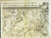
An exact survey of the city's of London Westminster , XII
1 Blatt : 53 x 72 cm John Rocque
An exact survey of the city's of London Westminster , XI
1 Blatt : 53 x 71 cm John Rocque
London
Grosser Hand-Atlas über alle Theile der Erde in 170 Karten Meyer, J. Verlag des Bibliographischen Instituts
London Sheet K - OS Six-Inch Map
1 : 10560 Topographic maps Ordnance Survey Ordnance Survey
London Sheet K - OS Six-Inch Map
1 : 10560 Topographic maps Ordnance Survey Ordnance Survey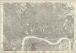
Middlesex XVII - OS Six-Inch Map
1 : 10560 Topographic maps Ordnance Survey Ordnance Survey
A PLAN of the CITIES of LONDON WESTMINSTER & the BOROUGH of SOUTHWARK Reduc'd to the Same Scale as those of PARIS ROME & DUBLIN
This map comprises two sheets with the title along the top in English and French, and a note comparing built-up areas of the four European capitals. City boundaries are outlined in colour. This is Robert Sayer's 1773 edition of the map first issued by Rocque in 1761. Rocque, John
A PLAN of the CITIES of LONDON & WESTMINSTER, THE BOROUGH OF SOUTHWARK and their Suburbs BY WILLIAM FADEN Geogr to the King MDCCLXXXV
The title of this map is arranged in an ornamental surround in which reclines the figure of Thamesis. Cross-hatching and stippling are used to distinguish land use, with differentiation made between fields and park land. Hyde Park features prominently on the plan. Deer were hunted here until 1768.It was also a well-known duelling ground. A particularly protracted and bloody duel was fought in 1772 between a Mr.Sheridan and a Captain Matthews over the honour of a certain Miss Lineley. Reports of the duel appeared in all the papers, scandalising the London public. Faden, William
LEIGH'S NEW PLAN OF LONDON 213
This map was published in the first edition of 'Leigh's New Picture of London’ in 1818. It shows Southwark Bridge and the proposed New North Road, across Finsbury Fields in Islington. Leigh, Samuel
LEIGH'S NEW PLAN OF LONDON 212
This is the second edition of a map of London first published in 'Leigh's New Picture of London'. The title appears along the top with a scale bar at the top right. The map is divided into half-mile squares with letters along the top borders for reference. It also shows Southwark Bridge and the proposed New North Road across Finsbury Fields. Hall, S.
Illustrated map of London, or, Stranger's guide to the public buildings, theatres, music halls, & and all places of interest
Bartlett, G. Warren George H. Young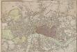
A New plan of LONDON and WESTMINSTER
The publisher's imprint of this folding map appears below the plan, with squares, open spaces, and the built-up area in the city distinguished from each other by colour. The map also shows the Regents Canal from Paddington to Shoreditch. Title and date are featured in the original slip case for the map, but don't appear on the map itself. Wallis, Edward


