Maps of Camden

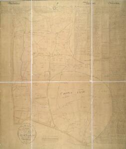
PLAN of the several Freehold Estates situated on the North side of the New Road within the Parish of St. Mary-le-bone and Parts of Hampstead and St. Pancras in the County of Middlesex
1 : 1584 This is Crace's own copy of an 18th-Century plan of the estates north of the New Road at Marylebone. The title and scale bar feature at bottom left, with compass at top centre, and descriptive notes at top left and down the right margin of the sheet. Outline colour marks the boundaries of estates and a single black line those of fields within the estate. The plan also reports the names of landlords and tenant occupiers, with key to the dimensions of each field and estate in a table above the plan. Jones, John
Charles Booth's descriptive map of London poverty 1889
Charles Booth
A PLAN for the improvements of a FREEHOLD ESTATE call'd ST. IOHN'S WOOD situated in the Parishes of MARYLEBONE & HAMPSTEAD propos'd by Spurrier & Phipps
1 : 7380 The title of this plan of proposed residential developments at St. John's Wood, appears in a tablet at bottom left. A key to the dimensions of lots appears in a tablet at bottom right, with scale noted at the foot of the plate. The revolutionary layout of the estate included a grand circus (never built) surrounded by semi-detatched properties. Spurrier & Phipps
THE REGENT'S PARK
1 : 4800 This plan was commissioned by the House of Commons and issued as a supplement to the Wood, Forests and Land Revenues report. The plan's title and imprint are at top right, with a scale bar and key at bottom right. The part of the park to be opened to the public is shown in pale yellow. The grounds of the Zoological Society and the Royal Botanic Society are shown in pink. The areas to be fenced off to protect the privacy of the local residents are shown in dark green. The land to the north of the park recently acquired by Eton College is shown in pale green, and that acquired by Lord Southampton, in pink. Basire, James
Some account of the proposed improvements of the Western part of London, by the formation of the Regent's Park, the new street, the new sewer. ... Illustrated by plans and accompanied by critical observations.

IMPROVED PLAN of the Termination of the GRAND JUNCTION CANAL at PADDINGTON With the Intended New Streets on the Estates of the Bishop of London
1 : 4800 The old course of the canal is indicated in blue.The improvements to the canal included: three new wharfs with enclosed reservoirs, at "A"; a service reservoir, at "B"; the enlargement of the canal by Arrow Road to allow barges to dock, at "C"; and a new basin for leisure boats, at "D". Also noted are three-and-a-half acres of land claimed by a Mr White, indicated by the letter "E".
London (1915- Numbered sheets) IV.8 (includes: Paddington; St Marylebone) - 25 Inch Map
1 : 2500 Topographic maps Ordnance Survey Ordnance Survey
London (1915- Numbered sheets) IV.8 (includes: Paddington; St Marylebone) - 25 Inch Map
1 : 2500 Topographic maps Ordnance Survey Ordnance Survey
London (Edition of 1894-96) XLVIII (includes: Paddington; St Marylebone) - 25 Inch Map
1 : 2500 Topographic maps Ordnance Survey Ordnance Survey
London (First Editions c1850s) XXIV (includes: Paddington; St Marylebone) - 25 Inch Map
1 : 2500 Topographic maps Ordnance Survey Ordnance Survey
London (1915- Numbered sheets) IV.4 (includes: Hampstead; St Marylebone) - 25 Inch Map
1 : 2500 Topographic maps Ordnance Survey Ordnance Survey
London (1915- Numbered sheets) IV.4 (includes: Hampstead; St Marylebone) - 25 Inch Map
1 : 2500 Topographic maps Ordnance Survey Ordnance Survey
London (First Editions c1850s) XV (includes: Hampstead; St Marylebone) - 25 Inch Map
1 : 2500 Topographic maps Ordnance Survey Ordnance Survey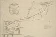
ORIGINAL PLAN of the Termination of the GRAND JUNCTION CANAL at PADDINGTON as Agreed with the Bishop of London and Confirmed by Act of Parliament to the Company
The land belonging to the Bishop of London is outlined in red, while another the property of another landowner, Mr Crompton, is outlined in yellow. Anonymous
Plan of the Estate in the vicinity of THE REGENT'S PARK &c. being a portion of the FREEHOLD GROUND RENTS OF THE LORD SOUTHAMPTON
1 : 2004 The title of this plan appears at top left, with compass at bottom centre and scale bar at bottom right. Produced for the sale at auction of the estate in 1840, the plan shows lots numbered for reference, along with the nearby Regent's Canal and the land being developed by the Birmingham and London Railway Company. Madeley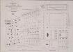
Plan of part of the ST. JOHN'S WOOD ESTATE ST. MARY LE BONE the property of LIEU.T COL.L EYRE.
1 : 2484 Plan of part of the Eyre Estate in St. John's Wood with title and compass rose at top left and scale bar at the foot of the plate, showing the proposed site for the new cricket ground at Lords.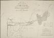
PLAN of the LANDS at PADDINGTON Proposed to be Leased and Exchanged by the Bishop of London and his Lessees AND THE Grand JUNCTION CANAL Company.
1 : 3168 Paddington was a predominantly rural area until the end of the 18th century.The Bishop of London granted the Grand Junction Canal Company permission to extend the canal from Brentford to Paddington.The Paddington Estate Act also allowed developers to start building on the estate.The title of this plan appears at top left. A reference table at bottom right gives a key to hatching and the dimensions of lots that formed part of the lease and exchange between the bishop and the canal company. Cary, J.
Insurance Plan of London North West District Vol. C: Second Key Plan B
1 : 480 This "key plan" indicates coverage of the Goad 1900 series of fire insurance maps of London that were originally produced to aid insurance companies in assessing fire risks. The building footprints, their use (commercial, residential, educational, etc.), the number of floors and the height of the building, as well as construction materials (and thus risk of burning) and special fire hazards (chemicals, kilns, ovens) were documented in order to estimate premiums. Names of individual businesses, property lines, and addresses were also often recorded. Together these maps provide a rich historical shapshot of the commercial activity and urban landscape of towns and cities at the time. The British Library holds a comprehensive collection of fire insurance plans produced by the London-based firm Charles E. Goad Ltd. dating back to 1885. These plans were made for most important towns and cities of the British Isles at the scales of 1:480 (1 inch to 40 feet), as well as many foreign towns at 1:600 (1 inch to 50 feet). Chas E Goad Limited Chas E Goad Limited
London (1915- Numbered sheets) V.1 (includes: Hampstead; St Pancras) - 25 Inch Map
1 : 2500 Topographic maps Ordnance Survey Ordnance Survey
London (First Editions c1850s) XVI (includes: Hampstead; St Pancras) - 25 Inch Map
1 : 2500 Topographic maps Ordnance Survey Ordnance Survey
London (1915- Numbered sheets) V.5 (includes: St Marylebone; St Pancras) - 25 Inch Map
1 : 2500 Topographic maps Ordnance Survey Ordnance Survey
London (First Editions c1850s) XXV (includes: St Marylebone; St Pancras) - 25 Inch Map
1 : 2500 Topographic maps Ordnance Survey Ordnance Survey
PLAN OF THE HAVERSTOCK HILL AND KENTISH TOWN ESTATE, being a portion of the FREEHOLD GROUND RENTS OF THE LORD SOUTHAMPTON
1 : 1968 The development of Kentish Town as a predominantly middle-class residential suburb began in the 1840s. This plan of the Haverstock Hill and Kentish Town Estates was produced for the sale at auction of Lord Southampton's estate in 1840. The plan features title at top right, compass at top left, and scale bar at bottom left, with individual lots numbered for reference. Madeley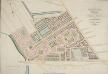
PADDINGTON Estate Design. Letting Ground on Building Leases opposite to HYDE PARK
1 : 2400 The development of Paddington began at the end of the Napoleonic wars, when the Bishop of London granted permission for building on his estate north of Hyde Park. Under Gutch's supervision, works continued into the 1850s, extending to Bayswater and the Edgware and Harrow Roads.The plan shows the new letting ground on the Bishop of London's estate in pink without shading, along with the reservoirs of the Grand Junction Canal Company and the ground plot of the Great Western Railway terminus.The title of this plan appears at top right, with compass rose at top left and scale bar at the foot of the plate. Gutch, George
London (1915- Numbered sheets) IV.12 (includes: City Of Westminster; Paddington; St Marylebone) - 25 Inch Map
1 : 2500 Topographic maps Ordnance Survey Ordnance Survey
London (First Editions c1850s) XXXIII (includes: City Of Westminster; Paddington; St Marylebone) - 25 Inch Map
1 : 2500 Topographic maps Ordnance Survey Ordnance Survey
Insurance Plan of London North West District Vol. C: Index Key Plan A
1 : 480 This "key plan" indicates coverage of the Goad 1900 series of fire insurance maps of London that were originally produced to aid insurance companies in assessing fire risks. The building footprints, their use (commercial, residential, educational, etc.), the number of floors and the height of the building, as well as construction materials (and thus risk of burning) and special fire hazards (chemicals, kilns, ovens) were documented in order to estimate premiums. Names of individual businesses, property lines, and addresses were also often recorded. Together these maps provide a rich historical shapshot of the commercial activity and urban landscape of towns and cities at the time. The British Library holds a comprehensive collection of fire insurance plans produced by the London-based firm Charles E. Goad Ltd. dating back to 1885. These plans were made for most important towns and cities of the British Isles at the scales of 1:480 (1 inch to 40 feet), as well as many foreign towns at 1:600 (1 inch to 50 feet). Chas E Goad Limited Chas E Goad Limited
London VI.9 - OS London Town Plan
1 : 1056 Topographic maps Ordnance Survey Ordnance Survey
London VI.19 - OS London Town Plan
1 : 1056 Topographic maps Ordnance Survey Ordnance Survey