Maps of Camden

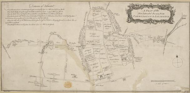
A Plan of the New Intended Road from Paddington to Islington.

Charles Booth's descriptive map of London poverty 1889
Charles Booth
London VII.NW - OS Six-Inch Map
1 : 10560 Topographic maps Ordnance Survey Ordnance Survey
A New PLAN of the CITY and LIBERTY of WESTMINSTER, Exhibiting all the New Streets & Roads, with the Residences of the Principal Nobility, Public Offices, &c. Not extant in any other Plan.
This map is by Thomas Jeffreys, an exceptional cartographer and publisher whose productions, including maps of North America, are considered to be among the finest of his age. This map shows the new developments in Westminster by use of a colour coding system indicating varying stages of completion. Portman Square (W1), a contemporary development, was begun the year before this map was published. It was built between 1764 and 84 for the landlord Henry William Portman on what was then considered the outskirts of town. Thomas Jeffreys
THE REGENT'S PARK
1 : 4800 This plan was commissioned by the House of Commons and issued as a supplement to the Wood, Forests and Land Revenues report. The plan's title and imprint are at top right, with a scale bar and key at bottom right. The part of the park to be opened to the public is shown in pale yellow. The grounds of the Zoological Society and the Royal Botanic Society are shown in pink. The areas to be fenced off to protect the privacy of the local residents are shown in dark green. The land to the north of the park recently acquired by Eton College is shown in pale green, and that acquired by Lord Southampton, in pink. Basire, James
A New and Accurate SURVEY of the PARISHES of St. Andrews Holbourn
Plan of the parishes of St. Andrew's, Holborn, St George's, Queen Square, St James's Clerkenwell, St Luke's, Old Street, St Mary's Islington and the Charterhouse Liberty. Cole, B.
Some account of the proposed improvements of the Western part of London, by the formation of the Regent's Park, the new street, the new sewer. ... Illustrated by plans and accompanied by critical observations.

Collins' Illustrated Atlas of London with 7000 references, in 36 plates of the principal routes between St. Paul's and the suburbs, from a survey made expressly for this work, by R. Jarman

Insurance Plan of London North District Vol. D (Key C): sheet 3-1
1 : 480 This detailed 1901 plan of London is one of a series of twenty sheets in an atlas originally produced to aid insurance companies in assessing fire risks. The building footprints, their use (commercial, residential, educational, etc.), the number of floors and the height of the building, as well as construction materials (and thus risk of burning) and special fire hazards (chemicals, kilns, ovens) were documented in order to estimate premiums. Names of individual businesses, property lines, and addresses were also often recorded. Together these maps provide a rich historical shapshot of the commercial activity and urban landscape of towns and cities at the time. The British Library holds a comprehensive collection of fire insurance plans produced by the London-based firm Charles E. Goad Ltd. dating back to 1885. These plans were made for most important towns and cities of the British Isles at the scales of 1:480 (1 inch to 40 feet), as well as many foreign towns at 1:600 (1 inch to 50 feet). Chas E Goad Limited Chas E Goad Limited
Insurance Plan of London Vol. xi: sheet 372-2
1 : 480 This detailed 1891 plan of London is one of a series of forty seven sheets in an atlas originally produced to aid insurance companies in assessing fire risks. The building footprints, their use (commercial, residential, educational, etc.), the number of floors and the height of the building, as well as construction materials (and thus risk of burning) and special fire hazards (chemicals, kilns, ovens) were documented in order to estimate premiums. Names of individual businesses, property lines, and addresses were also often recorded. Together these maps provide a rich historical shapshot of the commercial activity and urban landscape of towns and cities at the time. The British Library holds a comprehensive collection of fire insurance plans produced by the London-based firm Charles E. Goad Ltd. dating back to 1885. These plans were made for most important towns and cities of the British Isles at the scales of 1:480 (1 inch to 40 feet), as well as many foreign towns at 1:600 (1 inch to 50 feet). Chas E Goad Limited Chas E Goad Limited
London (1915- Numbered sheets) V.5 (includes: St Marylebone; St Pancras) - 25 Inch Map
1 : 2500 Topographic maps Ordnance Survey Ordnance Survey
London (First Editions c1850s) XXV (includes: St Marylebone; St Pancras) - 25 Inch Map
1 : 2500 Topographic maps Ordnance Survey Ordnance Survey
London (1915- Numbered sheets) V.6 (includes: Finsbury; Holborn; Islington; St Pancras) - 25 Inch Map
1 : 2500 Topographic maps Ordnance Survey Ordnance Survey
London (First Editions c1850s) XXVI (includes: Finsbury; Holborn; Islington; St Pancras) - 25 Inch Map
1 : 2500 Topographic maps Ordnance Survey Ordnance Survey
Insurance Plan of London North West District Vol. C: Index Key Plan A
1 : 480 This "key plan" indicates coverage of the Goad 1900 series of fire insurance maps of London that were originally produced to aid insurance companies in assessing fire risks. The building footprints, their use (commercial, residential, educational, etc.), the number of floors and the height of the building, as well as construction materials (and thus risk of burning) and special fire hazards (chemicals, kilns, ovens) were documented in order to estimate premiums. Names of individual businesses, property lines, and addresses were also often recorded. Together these maps provide a rich historical shapshot of the commercial activity and urban landscape of towns and cities at the time. The British Library holds a comprehensive collection of fire insurance plans produced by the London-based firm Charles E. Goad Ltd. dating back to 1885. These plans were made for most important towns and cities of the British Isles at the scales of 1:480 (1 inch to 40 feet), as well as many foreign towns at 1:600 (1 inch to 50 feet). Chas E Goad Limited Chas E Goad Limited
London (1915- Numbered sheets) V.10 (includes: City Of Westminster; Finsbury; Holborn; Inner Temple; Lambeth St Mary; London; Southwark) - 25 Inch Map
1 : 2500 Topographic maps Ordnance Survey Ordnance Survey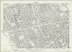
London (1915- Numbered sheets) V.9 (includes: City Of Westminster; St Marylebone; St Pancras) - 25 Inch Map
1 : 2500 Topographic maps Ordnance Survey Ordnance Survey
London (First Editions c1850s) XXXIV (includes: City Of Westminster; St Marylebone; St Pancras) - 25 Inch Map
1 : 2500 Topographic maps Ordnance Survey Ordnance Survey
Insurance Plan of London: sheet 6
This detailed 1889 plan of London is one of a series of six sheets in an atlas originally produced to aid insurance companies in assessing fire risks. The building footprints, their use (commercial, residential, educational, etc.), the number of floors and the height of the building, as well as construction materials (and thus risk of burning) and special fire hazards (chemicals, kilns, ovens) were documented in order to estimate premiums. Names of individual businesses, property lines, and addresses were also often recorded. Together these maps provide a rich historical shapshot of the commercial activity and urban landscape of towns and cities at the time. The British Library holds a comprehensive collection of fire insurance plans produced by the London-based firm Charles E. Goad Ltd. dating back to 1885. These plans were made for most important towns and cities of the British Isles at the scales of 1:480 (1 inch to 40 feet), as well as many foreign towns at 1:600 (1 inch to 50 feet). Chas E Goad Limited Chas E Goad Limited
Plan OF THE PARISHES OR DIVISION OF St Giles in the Fields And ST. GEORGE, BLOOMSBURY. 1815 2
1 : 2400 Different pastel colours describe the Parish divisions within St. Giles in the Fields and St. George's, Bloomsbury. A plan of the Burial Ground and Chapel of St. Giles in the Field, adjoining the church yard of St Pancreas, is located in a separate border. Montagu House was sold in 1755 to house the British museum. It was demolished to make way for Smirke''s building in the 1840''s. Hewitt, N.R.
To the Most Noble JOHN, DUKE OF BEDFORD. This Plan of the United Parishes of ST. GILES in the FIELDS & ST. GEORGE, BLOOMSBURY, 4
1 : 444 This map is dedicated to the Duke of Bedford as this area was the primary metropolitan estate of the Earls ans Dukes of Bedford. Russell was the family name of the Dukes of Bedford, hence Russell Square. Bedford house, built for the 3rd Earl of Bedford in 1586, lay adjacent to Montague house, later to be the British Museum, until 1705-6 when it was demolished. In the lower left hand corner is a vignette of a statue of a Duke of Bedford. A birds eye view of the British Museum and a view of the College of Surgeons are also included as is a statue of C.J Fox right hon, the orator. Wyld, James
Insurance Plan of London: General Key Plan of North Side of River
1 : 4800 This "key plan" indicates coverage of the Goad 1889 series of fire insurance maps of London that were originally produced to aid insurance companies in assessing fire risks. The building footprints, their use (commercial, residential, educational, etc.), the number of floors and the height of the building, as well as construction materials (and thus risk of burning) and special fire hazards (chemicals, kilns, ovens) were documented in order to estimate premiums. Names of individual businesses, property lines, and addresses were also often recorded. Together these maps provide a rich historical shapshot of the commercial activity and urban landscape of towns and cities at the time. The British Library holds a comprehensive collection of fire insurance plans produced by the London-based firm Charles E. Goad Ltd. dating back to 1885. These plans were made for most important towns and cities of the British Isles at the scales of 1:480 (1 inch to 40 feet), as well as many foreign towns at 1:600 (1 inch to 50 feet). Chas E Goad Limited Chas E Goad Limited
Insurance Plan of London Vol. xi Regent's Canal and Vicinity: Key Plan 2
1 : 4800 This "key plan" indicates coverage of the Goad 1891 series of fire insurance maps of London that were originally produced to aid insurance companies in assessing fire risks. The building footprints, their use (commercial, residential, educational, etc.), the number of floors and the height of the building, as well as construction materials (and thus risk of burning) and special fire hazards (chemicals, kilns, ovens) were documented in order to estimate premiums. Names of individual businesses, property lines, and addresses were also often recorded. Together these maps provide a rich historical shapshot of the commercial activity and urban landscape of towns and cities at the time. The British Library holds a comprehensive collection of fire insurance plans produced by the London-based firm Charles E. Goad Ltd. dating back to 1885. These plans were made for most important towns and cities of the British Isles at the scales of 1:480 (1 inch to 40 feet), as well as many foreign towns at 1:600 (1 inch to 50 feet). Chas E Goad Limited Chas E Goad Limited
PLAN OF A Street Proposed FROM CHARING CROSS TO PORTLAND PLACE.
1 : 6000 This is Nash's original design for Regent Street.The title appears at top right, with compass star and scale bar at the bottom left. The course of the street highlighted in yellow, with Crown property is highlighted in blue.Starting at Carlton House, Regent Street ran through crownland at Piccadilly (where a circus was built) before turning north-west along Swallow Street, in Soho, finally joining Portland Place north of Oxford Street. Thompson
A Plan of the intended IMPROVEMENTS, on the Estate of his Grace the Duke of BEDFORD. 1800 16
1 : 2784 The area of Bloomsbury represented in this plan has been part of the metropolitan estate of the Russell family, the Earls and Dukes of Bedford since the 17th century. Many of the names of the streets and squares reflect this connection. The plan shows the old British Museum simply marked ''museum'', Russell Square, Brunswick Square, Tavistock Square, Nursery Ground are all indicated as green spaces. Bloomsbury square is marked by a pecked line and coloured green. Bedford house has become Bedford Place, constructed in 1801-5 by James Burton. Under the 6th Duke of Bedford the area was developed north and east, principally by James Burton and Thomas Cubitt. The resulting squares became a favourite area for writers and painters. Neele
Insurance Plan of City of London Vol. II: Key Plan
1 : 480 This "key plan" indicates coverage of the Goad 1886 series of fire insurance maps of London that were originally produced to aid insurance companies in assessing fire risks. The building footprints, their use (commercial, residential, educational, etc.), the number of floors and the height of the building, as well as construction materials (and thus risk of burning) and special fire hazards (chemicals, kilns, ovens) were documented in order to estimate premiums. Names of individual businesses, property lines, and addresses were also often recorded. Together these maps provide a rich historical shapshot of the commercial activity and urban landscape of towns and cities at the time. The British Library holds a comprehensive collection of fire insurance plans produced by the London-based firm Charles E. Goad Ltd. dating back to 1885. These plans were made for most important towns and cities of the British Isles at the scales of 1:480 (1 inch to 40 feet), as well as many foreign towns at 1:600 (1 inch to 50 feet). Chas E Goad Limited Chas E Goad Limited
A MAPP of the PARISH of ST GILES'S in the Fields taken from the last Servey, with Corrections and Additions 1-A
1 : 2748 Plan of the parish of St Giles's from the 1720 edition of Stowe's Survey of England. The plan features title in banner at top left, reference table down the right side of the plate, with compass and scale bar at bottom left. The boundaries of the parish are indicated by a pecked line. Blome, Richard
A plan of the City's Estate in Tottenham Court Road
This plan shows a proposed new street near Bedford Square on land owned by the City of London.In the notes on the left side of the sheet the rationale behind the different colours is explained.Gentlemen's houses are to be built with gardens, at the opposite end of which will be houses for shopkeepers.The shops will have large fronts opening on to Tottenham Court Road.The rear wall of the shop keepers houses are to have no lights or other openings, presumably so as not to overlook the gardens of the gentlemen. Metcalf, R.
Insurance Plan of London North West Vol. C: Key Plan
1 : 480 This "key plan" indicates coverage of the Goad 1889 series of fire insurance maps of London that were originally produced to aid insurance companies in assessing fire risks. The building footprints, their use (commercial, residential, educational, etc.), the number of floors and the height of the building, as well as construction materials (and thus risk of burning) and special fire hazards (chemicals, kilns, ovens) were documented in order to estimate premiums. Names of individual businesses, property lines, and addresses were also often recorded. Together these maps provide a rich historical shapshot of the commercial activity and urban landscape of towns and cities at the time. The British Library holds a comprehensive collection of fire insurance plans produced by the London-based firm Charles E. Goad Ltd. dating back to 1885. These plans were made for most important towns and cities of the British Isles at the scales of 1:480 (1 inch to 40 feet), as well as many foreign towns at 1:600 (1 inch to 50 feet). Chas E Goad Limited Chas E Goad Limited