Maps of Staden

Hostile Artillery Dispositions. Oostnieuwkerke
1 : 20000 First World War map. Hostile Artillery Dispositions. Oct.3rd. 1917. Sheet Oostnieuwerke. War Office
Plan parcellaire de la commune de Staeden : avec les mutations
1 : 5000 Royal Library of Belgium Map Room Popp, Philippe Christian (1805-1879) Popp, Philippe Christian (1805-1879)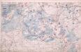
Target Map no.1
1 : 10000 First World War map. Target Map no.1. Shows centres of enemy activity etc. War Office
Plan parcellaire de la commune de Westroosebeke : avec les mutations
1 : 2500 Royal Library of Belgium Map Room Popp, Philippe Christian (1805-1879) Popp, Philippe Christian (1805-1879)
Plan parcellaire de la commune de Oostnieuwkerke : avec les mutations
1 : 5000 Royal Library of Belgium Map Room Popp, Philippe Christian (1805-1879) Popp, Philippe Christian (1805-1879)
Plan parcellaire de la commune de Roulers : avec les mutations
1 : 5000 Royal Library of Belgium Map Room Popp, Philippe Christian (1805-1879) Popp, Philippe Christian (1805-1879)
Plan parcellaire de la commune de Passchendaele : avec les mutations
1 : 5000 Royal Library of Belgium Map Room Popp, Philippe Christian (1805-1879) Popp, Philippe Christian (1805-1879)
Plan parcellaire de la commune de Hooglede : avec les mutations
1 : 5000 Royal Library of Belgium Map Room Popp, Philippe Christian (1805-1879) Popp, Philippe Christian (1805-1879)
Plan parcellaire de la commune de Moorslede : avec les mutations
1 : 5000 Royal Library of Belgium Map Room Popp, Philippe Christian (1805-1879) Popp, Philippe Christian (1805-1879)
Map showing wet areas on Passchendaele Front
1 : 10000 First World War map showing wet areas on Passchendaele Front. Dec. 1917. ('Wet', 'Very We't, 'Flooded ponds of swamps'). War Office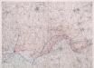
Front at Ypres. Oct. 1917. Special.
1 : 40000 First World War map of the Front at Ypres. Oct. 1917. Special. Charts British progress on the front with dates. War Office
Map showing progress in Ypres area. Oct. 1917.
1 : 40000 First World War map showing progress in Ypres area. 12th October 1917. War Office
Plan parcellaire de la commune de Langemarcq : avec les mutations
1 : 5000 Royal Library of Belgium Map Room Popp, Philippe Christian (1805-1879) Popp, Philippe Christian (1805-1879)
Plan parcellaire de la commune de Langemarcq : avec les mutations
1 : 5000 Royal Library of Belgium Map Room Popp, Philippe Christian (1805-1879) Popp, Philippe Christian (1805-1879)
Plan parcellaire de la commune de Rumbeke : avec les mutations
1 : 5000 Royal Library of Belgium Map Room Popp, Philippe Christian (1805-1879) Popp, Philippe Christian (1805-1879)
Plan parcellaire de la commune de Clercken : avec les mutations
1 : 5000 Royal Library of Belgium Map Room Popp, Philippe Christian (1805-1879) Popp, Philippe Christian (1805-1879)
Plan parcellaire de la commune de Gits : avec les mutations
1 : 5000 Royal Library of Belgium Map Room Popp, Philippe Christian (1805-1879) Popp, Philippe Christian (1805-1879)
Carte particuliere des environs de Menin, Courtray, Ypre, Dixmunde, et Deynse
1 : 110000 Belgie Fricx, Eugene Henry chez Eugene Henry Friex
Carte Particuliere des environs de Menin, Courtray, Ypre, Dixmude et Deynse
1 : 116600 Mollova mapová sbírka Fricx, Eugène Henry Harrewyn, Jacques Fricx, Eugené Henry
NOVA ET EXACTA TABVLA GEOGRAPHICA SALÆ ET CASTELLANIÆ IPRENSIS. De Casselrie van Ipre. LA CHASTELENIE D'IPRE. ANNO M DC XXXXI
Vedastus du Plouich fec. Henricus Hondius excudebat
Flandriae Comitatus Pars Septentrionalis
1 : 133000 Mollova mapová sbírka Visscher, Nicolaes Schenk, Peter II
CASTELLANIÆ | CORTVRIACENSIS | TABVLA
[Amsterdam : Joan Blaeu]
Carte Particuliere des environs de Menin, Courtray, Ypre, Dixmude et Deynse
1 : 250000 Mollova mapová sbírka Seutter, Matthäus Seutter, Matthäus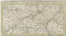
Menin in Flandern mitt nahe gelegenen Staedtten Ypern, Cortryck, Ryssel, Dornick etc.
1 : 250000 Mollova mapová sbírka Bodenehr, Gabriel Bodenehr, Gabriel
Flandriae Comitatus Pars Media
1 : 133000 Mollova mapová sbírka Visscher, Nicolaes Schenk, Peter II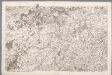
VII, uit: Carte chorographique des Pays-Bas Autrichiens / ... par le Comte de Ferraris ; gravée par L.A. Dupuis
1 : 86400 Annotatie: Lit.: Les militaires et la cartographie des Pays-Bas méridionaux et de la Principauté de Liège à la fin du XVIIe et au XVIII siècle / Claire Lemoine-Isabeau. - Bruxelles, 1984, p. 206-212; La cartographie au XVIIIe siècle et l'oeuvre du Comte de Ferraris (1726-1814) : colloque international, Spa, 8-11 sept. 1976. - Bruxelles, 1978; Met opdracht aan keizer Joseph II (bl.XVI); Met plattegrond van Brussel (bl. XXI), overzichtskaart (bl. XXII) en bladwijzer (bl. XXIII); Ontbreekt: bl. I-III en XXI; Voor aanwezige bladen zie overzichtsblad Ferraris, Johann Joseph; Dupuis, L. A. [S.l. : s.n.]
Flandriae comitatus pars media, comprehendens castellaniam Yprensem, Cortracensem, Aldenardensem
1 : 130000 per Nicol. Visscher Amst. Bat. Amst. Bat. : per Nicol. Visscher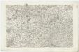
VII ; 2.J., uit: Carte chorographique des Pays-Bas Autrichiens / ... par le Comte de Ferraris ; gravée par L.A. Dupuis
1 : 86400 Annotatie: Bladen linksboven genummerd met Romeinse cijfers, rechtsboven met een cijfer en een letter; Met opdracht aan keizer Joseph II (bl.XVI); Met plattegrond van Brussel (bl. XXI), overzichtskaart (bl. XXII) en bladwijzer (bl. XXIII); Annotatie geografische gegevens: Schaalstokken: Echelle de Toises ou de Lieues communes de France; Echelle de Verges ou de Lieues de Brabant; Echelle de Milles d'Allemagne (bl. XVII); Echelle de Mètres; In de hoeken lengte- en breedtematen T.M.e en T.P.e Joseph-Jean François Ferraris Comte de 1726-1814; L.A. Dupuis [S.l. : s.n.]
IPRENSIS | Episcopatus
Ioh. Blaeu excud.


