Maps of Ieper

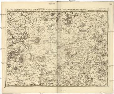
Carte particuliere des environs de Menin, Courtray, Ypre, Dixmunde, et Deynse
1 : 110000 Belgie Fricx, Eugene Henry chez Eugene Henry Friex
Carte Particuliere des environs de Menin, Courtray, Ypre, Dixmude et Deynse
1 : 116600 Mollova mapová sbírka Fricx, Eugène Henry Harrewyn, Jacques Fricx, Eugené Henry
Carte Particuliere des environs de Menin, Courtray, Ypre, Dixmude et Deynse
1 : 250000 Mollova mapová sbírka Seutter, Matthäus Seutter, Matthäus
Menin in Flandern mitt nahe gelegenen Staedtten Ypern, Cortryck, Ryssel, Dornick etc.
1 : 250000 Mollova mapová sbírka Bodenehr, Gabriel Bodenehr, Gabriel
Flandriae Comitatus Pars Media
1 : 133000 Mollova mapová sbírka Visscher, Nicolaes Schenk, Peter II
NOVA ET EXACTA TABVLA GEOGRAPHICA SALÆ ET CASTELLANIÆ IPRENSIS. De Casselrie van Ipre. LA CHASTELENIE D'IPRE. ANNO M DC XXXXI
Vedastus du Plouich fec. Henricus Hondius excudebat
CASTELLANIÆ | CORTVRIACENSIS | TABVLA
[Amsterdam : Joan Blaeu]
Map showing progress in Ypres area. Oct. 1917.
1 : 40000 First World War map showing progress in Ypres area. 12th October 1917. War Office
Front at Ypres. Oct. 1917. Special.
1 : 40000 First World War map of the Front at Ypres. Oct. 1917. Special. Charts British progress on the front with dates. War Office
Ypres. Sheeet 28. no.4
1 : 40000 First World War map of Ypres. Sheeet 28. 1915. [GSGS 2743] Has height shading and contours. War Office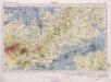
Ypres. Sheeet 28. no.2
1 : 40000 First World War map of Ypres. Sheeet 28. 1915. [GSGS 2743] Has height shading and contours. War Office
Ypres. Sheeet 28. no.1
1 : 40000 First World War map of Ypres. Sheeet 28. 1915. [GSGS 2743] Has height shading and contours. War Office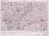
Ypres. Sheeet 28. no.3
1 : 40000 First World War map of Ypres. Sheeet 28. 1915. [GSGS 2743] Has height shading and contours. War Office
Disegno di Covtray
Kortrijk (Belgie) Bouttats, Gerhaert
Carte Particuliere des environs de Menin, Courtray, Ypre, Dixmude, et Deynse
1 : 116600 Mollova mapová sbírka Fricx, Eugène Henry Covens, Johannes I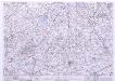
France & Belgium Scale 1 : 25,000, Tourcoing
Sheet 52NW from the map series: France & Belgium. Scale 1 : 25,000. [G.S.G.S. No. 4041. A.M.S. M863] [London] : War Office
CASTELLANIA | ALDENARDENSIS
[Amsterdam : Joan Blaeu]
Plan parcellaire de la commune de Langemarcq : avec les mutations
1 : 5000 Royal Library of Belgium Map Room Popp, Philippe Christian (1805-1879) Popp, Philippe Christian (1805-1879)
Plan parcellaire de la commune de Langemarcq : avec les mutations
1 : 5000 Royal Library of Belgium Map Room Popp, Philippe Christian (1805-1879) Popp, Philippe Christian (1805-1879)
Hostile Artillery Dispositions. Oostnieuwkerke
1 : 20000 First World War map. Hostile Artillery Dispositions. Oct.3rd. 1917. Sheet Oostnieuwerke. War Office
Plan parcellaire de la commune de Roulers : avec les mutations
1 : 5000 Royal Library of Belgium Map Room Popp, Philippe Christian (1805-1879) Popp, Philippe Christian (1805-1879)
Plan parcellaire de la commune de Meulebeke : avec les mutations
1 : 5000 Royal Library of Belgium Map Room Popp, Philippe Christian (1805-1879) Popp, Philippe Christian (1805-1879)
Plan parcellaire de la commune de Reninghelst : avec les mutations
1 : 5000 Royal Library of Belgium Map Room Popp, Philippe Christian (1805-1879) Popp, Philippe Christian (1805-1879)
Plan parcellaire de la commune de Reninghelst : avec les mutations
1 : 5000 Royal Library of Belgium Map Room Popp, Philippe Christian (1805-1879) Popp, Philippe Christian (1805-1879)
Plan parcellaire de la commune de Moorslede : avec les mutations
1 : 5000 Royal Library of Belgium Map Room Popp, Philippe Christian (1805-1879) Popp, Philippe Christian (1805-1879)
Plan parcellaire de la commune de Merckem : avec les mutations
1 : 7500 Royal Library of Belgium Map Room Popp, Philippe Christian (1805-1879) Popp, Philippe Christian (1805-1879)
Plan parcellaire de la commune de Waereghem : avec les mutations
1 : 5000 Royal Library of Belgium Map Room Popp, Philippe Christian (1805-1879) Popp, Philippe Christian (1805-1879)
Plan parcellaire de la commune de Poperinghe : avec les mutations
1 : 5000 Royal Library of Belgium Map Room Popp, Philippe Christian (1805-1879) Popp, Philippe Christian (1805-1879)
Plan parcellaire de la commune de Poperinghe : avec les mutations
1 : 5000 Royal Library of Belgium Map Room Popp, Philippe Christian (1805-1879) Popp, Philippe Christian (1805-1879)