Maps of Passendale

Map showing wet areas on Passchendaele Front
1 : 10000 First World War map showing wet areas on Passchendaele Front. Dec. 1917. ('Wet', 'Very We't, 'Flooded ponds of swamps'). War Office
Plan parcellaire de la commune de Passchendaele : avec les mutations
1 : 5000 Royal Library of Belgium Map Room Popp, Philippe Christian (1805-1879) Popp, Philippe Christian (1805-1879)
Plan parcellaire de la commune de Moorslede : avec les mutations
1 : 5000 Royal Library of Belgium Map Room Popp, Philippe Christian (1805-1879) Popp, Philippe Christian (1805-1879)
Target Map no.1
1 : 10000 First World War map. Target Map no.1. Shows centres of enemy activity etc. War Office
Hostile Artillery Dispositions. Oostnieuwkerke
1 : 20000 First World War map. Hostile Artillery Dispositions. Oct.3rd. 1917. Sheet Oostnieuwerke. War Office
Plan parcellaire de la commune de Zonnebeke : avec les mutations
1 : 5000 Royal Library of Belgium Map Room Popp, Philippe Christian (1805-1879) Popp, Philippe Christian (1805-1879)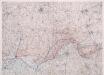
Front at Ypres. Oct. 1917. Special.
1 : 40000 First World War map of the Front at Ypres. Oct. 1917. Special. Charts British progress on the front with dates. War Office
Map showing progress in Ypres area. Oct. 1917.
1 : 40000 First World War map showing progress in Ypres area. 12th October 1917. War Office
Carte particuliere des environs de Menin, Courtray, Ypre, Dixmunde, et Deynse
1 : 110000 Belgie Fricx, Eugene Henry chez Eugene Henry Friex
Carte Particuliere des environs de Menin, Courtray, Ypre, Dixmude et Deynse
1 : 116600 Mollova mapová sbírka Fricx, Eugène Henry Harrewyn, Jacques Fricx, Eugené Henry
Menin in Flandern mitt nahegelegenen Staedten Ypern, Cortryck, Ryssel, Dornick etc
1 : 252000 Flandry Bodenehr, Gabriel G. Bodenehr
NOVA ET EXACTA TABVLA GEOGRAPHICA SALÆ ET CASTELLANIÆ IPRENSIS. De Casselrie van Ipre. LA CHASTELENIE D'IPRE. ANNO M DC XXXXI
Vedastus du Plouich fec. Henricus Hondius excudebat
CASTELLANIÆ | CORTVRIACENSIS | TABVLA
[Amsterdam : Joan Blaeu]
Carte Particuliere des environs de Menin, Courtray, Ypre, Dixmude et Deynse
1 : 250000 Mollova mapová sbírka Seutter, Matthäus Seutter, Matthäus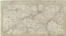
Menin in Flandern mitt nahe gelegenen Staedtten Ypern, Cortryck, Ryssel, Dornick etc.
1 : 250000 Mollova mapová sbírka Bodenehr, Gabriel Bodenehr, Gabriel
Flandriae Comitatus Pars Media
1 : 133000 Mollova mapová sbírka Visscher, Nicolaes Schenk, Peter II
Plan de la situation de l'Armée allié campée au bord de l'Eescaut 1744, de même que l'Armée françoise, retranchée derrière La Lis, l'année 1744
1 : 140000
VII, uit: Carte chorographique des Pays-Bas Autrichiens / ... par le Comte de Ferraris ; gravée par L.A. Dupuis
1 : 86400 Annotatie: Lit.: Les militaires et la cartographie des Pays-Bas méridionaux et de la Principauté de Liège à la fin du XVIIe et au XVIII siècle / Claire Lemoine-Isabeau. - Bruxelles, 1984, p. 206-212; La cartographie au XVIIIe siècle et l'oeuvre du Comte de Ferraris (1726-1814) : colloque international, Spa, 8-11 sept. 1976. - Bruxelles, 1978; Met opdracht aan keizer Joseph II (bl.XVI); Met plattegrond van Brussel (bl. XXI), overzichtskaart (bl. XXII) en bladwijzer (bl. XXIII); Ontbreekt: bl. I-III en XXI; Voor aanwezige bladen zie overzichtsblad Ferraris, Johann Joseph; Dupuis, L. A. [S.l. : s.n.]
GALLOFLANDRIA, | in qua CASTELLANIÆ | LILANA, DVACENA, & ORCHIESIA, cum dependentibus; | necnon TORNACVM, & TORNACESIVM
Auctore Martino Doué Gallo-Flandro. Guiljelmus Blaeu excudit.
Flandriae comitatus pars media, comprehendens castellaniam Yprensem, Cortracensem, Aldenardensem
1 : 130000 per Nicol. Visscher Amst. Bat. Amst. Bat. : per Nicol. Visscher
VII ; 2.J., uit: Carte chorographique des Pays-Bas Autrichiens / ... par le Comte de Ferraris ; gravée par L.A. Dupuis
1 : 86400 Annotatie: Bladen linksboven genummerd met Romeinse cijfers, rechtsboven met een cijfer en een letter; Met opdracht aan keizer Joseph II (bl.XVI); Met plattegrond van Brussel (bl. XXI), overzichtskaart (bl. XXII) en bladwijzer (bl. XXIII); Annotatie geografische gegevens: Schaalstokken: Echelle de Toises ou de Lieues communes de France; Echelle de Verges ou de Lieues de Brabant; Echelle de Milles d'Allemagne (bl. XVII); Echelle de Mètres; In de hoeken lengte- en breedtematen T.M.e en T.P.e Joseph-Jean François Ferraris Comte de 1726-1814; L.A. Dupuis [S.l. : s.n.]
Le Diocese De Tournay ou font Exactement Marquées Les Lignes Levé & Gravé Par Ordre Expres Du Roy [...] [Karte], in: Atlas nouveau, contenant toutes les parties du monde [...], Bd. 2, S. 52.
1 Karte aus Atlas Sanson, Nicolas Jaillot, Alexis Hubert und Mortier, Pieter
Gallo Flandria, in qua Castellaniae Lilana, Duacena, & Archiesia, cum dependentibus; neenon Tornacum,& Tornacesium. [Karte], in: Novus Atlas, das ist, Weltbeschreibung, Bd. 1, S. 368.
1 Karte aus Atlas Blaeu, Joan Blaeu, Willem Janszoon
Galloflandria, in qua Castellaniae Lilana, Duacena, & Orchiesia, cum dependentibus; neenon Tornacum,& Tornacesium. [Karte], in: Theatrum orbis terrarum, sive, Atlas novus, Bd. 1, S. 381.
1 Karte aus Atlas Blaeu, Joan Blaeu, Willem Janszoon
Gallo Flandria, in qua Castellaniae Lilana, Duacena, & Orchiesia, cum dependentibus; necnon Tornacum, & Tornacesium. [Karte], in: Le théâtre du monde, ou, Nouvel atlas contenant les chartes et descriptions de tous les païs de la terre, Bd. 1, S. 397.
1 Karte aus Atlas Blaeu, Willem Janszoon und Blaeu, Joan Blaeu, Willem Janszoon
IPRENSIS | Episcopatus
Ioh. Blaeu excud.
Artesia vulgo Artois, et Sedes Belli in Picardia &c Stoel des OOrlogs in Artois en Picardy, enz
1 : 250000 Mollova mapová sbírka Allard, Abraham Allart, Abraham
Carte du département du Nord ou les provinces de Flandre du Hainaut et du Cambresis, 1
1 Blatt : 47 x 58 cm s.n.
FLANDRIÆ | TEVTONICÆ | PARS ORIENTALIOR
Guilielmus et Iohannes Blaeuw exc. Amsterdami


