Maps of Ceredigion

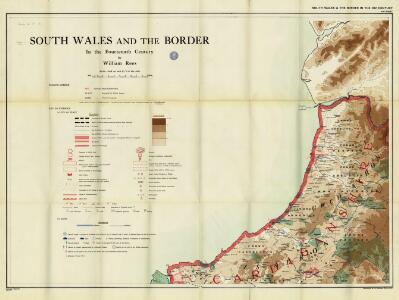
South Wales and the border in the 14th century
Rees, William Ordnance Survey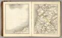
Sheets 29-30. (Cary's England, Wales, and Scotland).
1 : 360000 Cary, John, ca. 1754-1835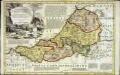
An accurate map of Cardigan Shire
1 Karte : Kupferdruck ; 33 x 52 cm Kitchin; Tinney John Tinney
Ceretica; sive Cardiganensis comitatus; anglis Cardigan Shire
1 Karte : Kupferdruck ; 36 x 48 cm Blaeu Joan Blaeu
Aberystwyth - OS One-Inch Map
1 : 63360 Topographic maps Ordnance Survey Ordnance Survey
Capel Bettws
1 : 31680 Robert Dawson is author of this drawing, which shows west Wales from Carmarthenshire to Cardigan Bay. One of the best surveyors and draughtsmen, Dawson was employed on the Ordnance Survey for over forty years, also working as an instructor. Below the formal title of the plan, in the top left margin, is an area calculation in black ink. Brushwork interlinging ('hachuring') and colour washes depicting relief are combined with numerical annotations ('spot heights') describing the height of the land. Those altitudes noted in red ink are trigonometrically ascertained; those in black are estimated. Dawson, Robert
Aberystwyth 13
1 : 31680 This plan of Cardigan Bay extends from Aberystwyth at the top left to Llansantffraid at the bottom left. A stretch of the Cambrian Mountains and the peat bogs of Cors-goch Glan Teifi are depicted further inland. The map's scale is noted beneath the formal title and the area of the land recorded as 117.8114 square miles. The circular hole in the top right-hand corner indicates that an 'Ordnance Office Copy' blind stamp has been removed from the sheet. Archaeological sites are named in gothic script. Colour washes depicting relief are combined with numerical annotations in black ink. Dawson, Robert
Aberaeron (Hills) - OS One-Inch Revised New Series
1 : 63360 Topographic maps Ordnance Survey Ordnance Survey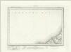
Aberaeron (Outline) - OS One-Inch Revised New Series
1 : 63360 Topographic maps Ordnance Survey Ordnance Survey
Barmouth (Hills) - OS One-Inch Revised New Series
1 : 63360 Topographic maps Ordnance Survey Ordnance Survey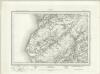
Barmouth (Outline) - OS One-Inch Revised New Series
1 : 63360 Topographic maps Ordnance Survey Ordnance Survey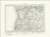
Aberystwyth (Outline) - OS One-Inch Revised New Series
1 : 63360 Topographic maps Ordnance Survey Ordnance Survey
Aberystwyth (Hills) - OS One-Inch Revised New Series
1 : 63360 Topographic maps Ordnance Survey Ordnance Survey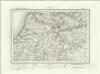
Llanilar (Outline) - OS One-Inch Revised New Series
1 : 63360 Topographic maps Ordnance Survey Ordnance Survey
Llanilar (Hills) - OS One-Inch Revised New Series
1 : 63360 Topographic maps Ordnance Survey Ordnance Survey
Plynlimmon
This drawing covers the boundary between the counties of Cardiganshire and Montgomeryshire. The border is marked as a red pecked line, following the course of the River Dovey for much of its length. Archaeological sites are noted in gothic script, an obligatory feature after 1816. A dot within a red triangle represents a trigonometric station, from which the surveyor took angular measurements in order to plot the location of topographical features. Giles, John C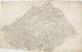
Lampeter
1 : 31680 This plan of Cardigan Bay and part of the county of Cardiganshire shows Lampeter and other settlements at lower left along the River Teify Valley. Pointed rocks below sharp cliffs, characteristic of the Cardiganshire coastline, are illustrated in elevation. Budgen, Thomas
Lampeter (Hills) - OS One-Inch Revised New Series
1 : 63360 Topographic maps Ordnance Survey Ordnance Survey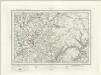
Lampeter (Outline) - OS One-Inch Revised New Series
1 : 63360 Topographic maps Ordnance Survey Ordnance Survey
Llangranog (Hills) - OS One-Inch Revised New Series
1 : 63360 Topographic maps Ordnance Survey Ordnance Survey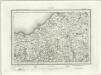
Llangranog (Outline) - OS One-Inch Revised New Series
1 : 63360 Topographic maps Ordnance Survey Ordnance Survey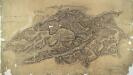
Cader Idris
1 : 31680 This plan of south Snowdonia runs from Cardigan Bay inland to the Cader Idris. Types of land use are indistinguishable in this drawing as no clear symbols have been used. The purple 'Ordnance Survey Manuscript Store' stamp at the top right margin is dated 9th April 1881. Dawson, Robert
Aberystwyth 4
1 : 31680 .The formal title of the drawing states that the survey was conducted under the supervision of Robert Dawson. One of the best surveyors and draughtsmen of the day, Dawson was employed on the Ordnance Survey for over forty years, also working as an instructor. The scale of the drawing is noted and the area of the land recorded as 44.6825 square miles in total. Archaeological sites are named in gothic script. Colour washes depicting relief are combined with numerical annotations or spot heights giving the heights of the hills. Those in red ink indicate trigonometrically ascertained altitudes while those in black are estimated. The paper carries a watermark from the James Whatman Turkey Mill in Kent dated 1819. Budgen, Thomas Jr.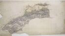
Abermaw
1 : 31680 This is the original protraction for a plan of Snowdonia, running from Barmouth Bay inland to Llanegryn. On his Welsh drawings, Dawson introduced the convention of 'relative command': the indication of the relative height of the hills by numbers - Hill 3 being higher than Hill 2, for example. Brushwork interlining ('hachures') and ink washes further describe relief. Pencil rays intersect across the map, evidence of measurements taken by the surveyor between fixed triangulation points. Dawson, Robert
Towyn
1 : 31680 The lack of shading to describe relief indicates that this is an outline drawing: the half-way stage between the original projection and the finished drawing. Towyn appears towards the bottom left of the surveyed area. Individual buildings are depicted in red ink, indicating they are made of stone. Trigonometrical stations are marked by a dot within a red triangle. At Taren Gadian, pencil lines can be seen radiating from the trigonometrical station, indicating the angular measurements the surveyor took from these points. A triangulation diagram on the reverse of the drawing enabled the draughtsman to plot topographical features precisely. Durrant , William R
SN25 & Parts of SN15 - OS 1:25,000 Provisional Series Map
1 : 25000 Topographic maps Ordnance Survey Ordnance Survey
SH60 & Parts of SH50 - OS 1:25,000 Provisional Series Map
1 : 25000 Topographic maps Ordnance Survey Ordnance Survey
SN35 & Parts of SN36 - OS 1:25,000 Provisional Series Map
1 : 25000 Topographic maps Ordnance Survey Ordnance Survey
SN69 & Parts of SN59 - OS 1:25,000 Provisional Series Map
1 : 25000 Topographic maps Ordnance Survey Ordnance Survey