Maps of Ceredigion
Sheets 29-30. (Cary's England, Wales, and Scotland).
1 : 360000 Cary, John, ca. 1754-1835
Ceretica; sive Cardiganensis Comitatus; Anglis Cardigan Shire. [Karte], in: Le théâtre du monde, ou, Nouvel atlas contenant les chartes et descriptions de tous les païs de la terre, Bd. 4, S. 363.
1 Karte aus Atlas Blaeu, Willem Janszoon und Blaeu, Joan Blaeu, Willem Janszoon
Ceretica; sive Cardiganensis Comitatus; Anglis Cardigan Shire. [Karte], in: Theatrum orbis terrarum, sive, Atlas novus, Bd. 4, S. 421.
1 Karte aus Atlas Blaeu, Joan Blaeu, Willem Janszoon
Ceretica; sive Cardiganensis Comitatus; Anglis Cardigan Shire. [Karte], in: Theatrum orbis terrarum, sive, Atlas novus, Bd. 4, S. 421.
1 Karte aus Atlas Blaeu, Joan Blaeu, Willem Janszoon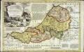
An accurate map of Cardigan Shire
1 Karte : Kupferdruck ; 33 x 52 cm Kitchin; Tinney John Tinney
Ceretica; sive Cardiganensis comitatus; anglis Cardigan Shire
1 Karte : Kupferdruck ; 36 x 48 cm Blaeu Joan Blaeu
Ceretica; sive Cardiganensis Comitatus; Anglis Cardigan Shire. [Karte], in: Novus atlas absolutissimus, Bd. 7, S. 395.
1 Karte aus Atlas Janssonius Offizin
CERETICA; | sive | CARDIGANensis | Comitatus; Anglis | CARDIGAN SHIRE.
[Amsterdam : Joan Blaeu]
Ceretica, sive Cardiganensis Comitatus, anglis Cardigan Shire
1 : 460000 Amstelodami : apud Joannem Janssonium
South Wales and the border in the 14th century
Rees, William Ordnance Survey
Aberystwyth - OS One-Inch Map
1 : 63360 Topographic maps Ordnance Survey Ordnance Survey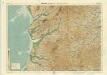
Aberystwyth, Sheet 16 - Bartholomew's "Half Inch to the Mile Maps" of England & Wales
1 : 126720 Topographic maps Bartholomew, John George John Bartholomew & Co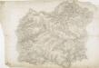
Hafod, Llanidloes
1 : 31680 .This plan of the,Ystwyth valley in the Cambrian Mountains is formally titled. The scale of the drawing is noted and the area of the land recorded,as 183.0453 square miles. Archaeological sites are named in gothic script. Colour washes depicting relief are combined with numerical annotations ('spot heights'), in red and black ink, indicating the height of the hills. The altitudes in red ink,are trigonometrically ascertained; those in black are estimated. Dawson, Robert
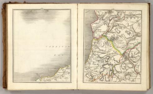
Aberystwyth 13
1 : 31680 This plan of Cardigan Bay extends from Aberystwyth at the top left to Llansantffraid at the bottom left. A stretch of the Cambrian Mountains and the peat bogs of Cors-goch Glan Teifi are depicted further inland. The map's scale is noted beneath the formal title and the area of the land recorded as 117.8114 square miles. The circular hole in the top right-hand corner indicates that an 'Ordnance Office Copy' blind stamp has been removed from the sheet. Archaeological sites are named in gothic script. Colour washes depicting relief are combined with numerical annotations in black ink. Dawson, Robert
Aberaeron (Hills) - OS One-Inch Revised New Series
1 : 63360 Topographic maps Ordnance Survey Ordnance Survey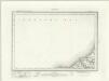
Aberaeron (Outline) - OS One-Inch Revised New Series
1 : 63360 Topographic maps Ordnance Survey Ordnance Survey
Barmouth (Hills) - OS One-Inch Revised New Series
1 : 63360 Topographic maps Ordnance Survey Ordnance Survey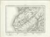
Barmouth (Outline) - OS One-Inch Revised New Series
1 : 63360 Topographic maps Ordnance Survey Ordnance Survey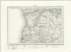
Aberystwyth (Outline) - OS One-Inch Revised New Series
1 : 63360 Topographic maps Ordnance Survey Ordnance Survey
Aberystwyth (Hills) - OS One-Inch Revised New Series
1 : 63360 Topographic maps Ordnance Survey Ordnance Survey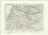
Llanilar (Outline) - OS One-Inch Revised New Series
1 : 63360 Topographic maps Ordnance Survey Ordnance Survey
Llanilar (Hills) - OS One-Inch Revised New Series
1 : 63360 Topographic maps Ordnance Survey Ordnance Survey
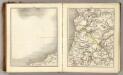
Plynlimmon
This drawing covers the boundary between the counties of Cardiganshire and Montgomeryshire. The border is marked as a red pecked line, following the course of the River Dovey for much of its length. Archaeological sites are noted in gothic script, an obligatory feature after 1816. A dot within a red triangle represents a trigonometric station, from which the surveyor took angular measurements in order to plot the location of topographical features. Giles, John C
Dinas-Mawddwy (Hills) - OS One-Inch Revised New Series
1 : 63360 Topographic maps Ordnance Survey Ordnance Survey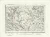
Dinas-Mawddwy (Outline) - OS One-Inch Revised New Series
1 : 63360 Topographic maps Ordnance Survey Ordnance Survey
Llanidloes (Hills) - OS One-Inch Revised New Series
1 : 63360 Topographic maps Ordnance Survey Ordnance Survey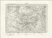
Llanidloes (Outline) - OS One-Inch Revised New Series
1 : 63360 Topographic maps Ordnance Survey Ordnance Survey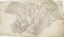
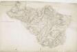
Cardiganshire
1 : 31680 This drawing is formally titled. Its scale is noted and the surveyed area recorded as 205.6742 square miles. Archaeological sites are named in gothic script. Colour washes depicting relief are combined with numerical annotations ('spot heights') in red and black ink giving the heights of the hills. Figures in red represent trigonometrically ascertained altitudes whereas those in black are estimates. On the top left margin a note, dated 1st April 1822, from draughtsman Robert Dawson reads: "Cws yr ychen Bannog, is an ancient Bank said to run from sea to sea. It could not be traced in this survey beyond Carn Cron. The Rev John Williams of Ystrad Meyric supposes it may be a British Road, or a Boundary between two tribes of the Britons". Dawson, Robert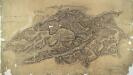
Cader Idris
1 : 31680 This plan of south Snowdonia runs from Cardigan Bay inland to the Cader Idris. Types of land use are indistinguishable in this drawing as no clear symbols have been used. The purple 'Ordnance Survey Manuscript Store' stamp at the top right margin is dated 9th April 1881. Dawson, Robert