Maps of Gwynedd
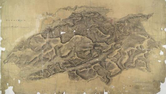
Cader Idris
1 : 31680 This plan of south Snowdonia runs from Cardigan Bay inland to the Cader Idris. Types of land use are indistinguishable in this drawing as no clear symbols have been used. The purple 'Ordnance Survey Manuscript Store' stamp at the top right margin is dated 9th April 1881. Dawson, Robert
Barmouth (Hills) - OS One-Inch Revised New Series
1 : 63360 Topographic maps Ordnance Survey Ordnance Survey
Barmouth (Outline) - OS One-Inch Revised New Series
1 : 63360 Topographic maps Ordnance Survey Ordnance Survey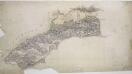
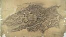
Abermaw
1 : 31680 This is the original protraction for a plan of Snowdonia, running from Barmouth Bay inland to Llanegryn. On his Welsh drawings, Dawson introduced the convention of 'relative command': the indication of the relative height of the hills by numbers - Hill 3 being higher than Hill 2, for example. Brushwork interlining ('hachures') and ink washes further describe relief. Pencil rays intersect across the map, evidence of measurements taken by the surveyor between fixed triangulation points. Dawson, Robert
SH71 - OS 1:25,000 Provisional Series Map
1 : 25000 Topographic maps Ordnance Survey Ordnance Survey
SH70 - OS 1:25,000 Provisional Series Map
1 : 25000 Topographic maps Ordnance Survey Ordnance Survey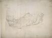
Towyn
1 : 31680 The lack of shading to describe relief indicates that this is an outline drawing: the half-way stage between the original projection and the finished drawing. Towyn appears towards the bottom left of the surveyed area. Individual buildings are depicted in red ink, indicating they are made of stone. Trigonometrical stations are marked by a dot within a red triangle. At Taren Gadian, pencil lines can be seen radiating from the trigonometrical station, indicating the angular measurements the surveyor took from these points. A triangulation diagram on the reverse of the drawing enabled the draughtsman to plot topographical features precisely. Durrant , William R
SH61 & Parts of SH51 - OS 1:25,000 Provisional Series Map
1 : 25000 Topographic maps Ordnance Survey Ordnance Survey
SH60 & Parts of SH50 - OS 1:25,000 Provisional Series Map
1 : 25000 Topographic maps Ordnance Survey Ordnance Survey
Merionethshire XXXII.SW - OS Six-Inch Map
1 : 10560 Topographic maps Ordnance Survey Ordnance Survey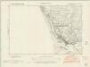
Merionethshire XXXVI.NW - OS Six-Inch Map
1 : 10560 Topographic maps Ordnance Survey Ordnance Survey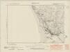
Merionethshire XXXVI.NW - OS Six-Inch Map
1 : 10560 Topographic maps Ordnance Survey Ordnance Survey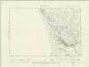
Merionethshire XXXVI.NW - OS Six-Inch Map
1 : 10560 Topographic maps Ordnance Survey Ordnance Survey
Merionethshire XXXVI.NW - OS Six-Inch Map
1 : 10560 Topographic maps Ordnance Survey Ordnance Survey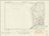
Merionethshire XXXVI.SW - OS Six-Inch Map
1 : 10560 Topographic maps Ordnance Survey Ordnance Survey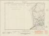
Merionethshire XXXVI.SW - OS Six-Inch Map
1 : 10560 Topographic maps Ordnance Survey Ordnance Survey
Merionethshire XXXVI.SW - OS Six-Inch Map
1 : 10560 Topographic maps Ordnance Survey Ordnance Survey
Merionethshire XXXVI.SW - OS Six-Inch Map
1 : 10560 Topographic maps Ordnance Survey Ordnance Survey
Merionethshire XLI.NW - OS Six-Inch Map
1 : 10560 Topographic maps Ordnance Survey Ordnance Survey
Merionethshire XLI.NW - OS Six-Inch Map
1 : 10560 Topographic maps Ordnance Survey Ordnance Survey
Merionethshire XLI.NW - OS Six-Inch Map
1 : 10560 Topographic maps Ordnance Survey Ordnance Survey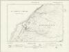
Merionethshire XLI.NW - OS Six-Inch Map
1 : 10560 Topographic maps Ordnance Survey Ordnance Survey
Merionethshire XLI.NW - OS Six-Inch Map
1 : 10560 Topographic maps Ordnance Survey Ordnance Survey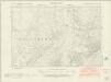
Merionethshire XXXII.SE - OS Six-Inch Map
1 : 10560 Topographic maps Ordnance Survey Ordnance Survey
Merionethshire XXXII.SE - OS Six-Inch Map
1 : 10560 Topographic maps Ordnance Survey Ordnance Survey
Merionethshire XXXII.SE - OS Six-Inch Map
1 : 10560 Topographic maps Ordnance Survey Ordnance Survey
Merionethshire XLI.SW - OS Six-Inch Map
1 : 10560 Topographic maps Ordnance Survey Ordnance Survey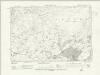
Merionethshire XLI.SW - OS Six-Inch Map
1 : 10560 Topographic maps Ordnance Survey Ordnance Survey
Merionethshire XLI.SW - OS Six-Inch Map
1 : 10560 Topographic maps Ordnance Survey Ordnance Survey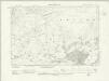
Merionethshire XLI.SW - OS Six-Inch Map
1 : 10560 Topographic maps Ordnance Survey Ordnance Survey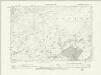
Merionethshire XLI.SW - OS Six-Inch Map
1 : 10560 Topographic maps Ordnance Survey Ordnance Survey