Maps of Havering

A coloured plan of part of the Marr Ditch at Purfleet, shewing the sluices, with projected alterations
Plan of the sluice at Purfleet in Essex. A new gunpowder magazine was built on this site in the mid 18th century. Water mills had stood here on the Marr Ditch (now known as the Mardyke) but these had the effect of letting salt water from the river seep into the land. This was thought to be detrimental to the land and so the mills were taken down and new sluices were built as a more efficient drainage system. Wooden floodgates were built to protect the fort from the danger of flooding from the River Thames.
A coloured plan of the buildings and houses belonging to his Majesty's Office of Ordnance at Purfleet
Plan of Purfleet in Essex. A magazine in Woolwich was damaged in an explosion and Act of Parliament was passed and land was purchased at Purfleet for a new magazine. Five new buildings were erected, each measuring approximately 140ft by 20ft. When full each magazine could hold ten thousand barrels of gunpowder. The potential for an explosion meant that the magazines were built with very thick walls and were positioned in hollows in the ground so that any explosion would be forced upwards. The Magazines stood within approximately 25 acres of ground.
An Exact SURVEY of the LANDS necessary yo be purchased by the CROWN pursuant to an Act of PARLIAMENT for Erecting MAGAZINES and other Buildings at PURFLEET in the County of ESSEX.
Plan of Purfleet in Essex. A magazine in Woolwich was damaged in an explosion and Act of Parliament was passed and land was purchased at Purfleet for a new magazine. Five new buildings were erected, each measuring approximately 140ft by 20ft. When full each magazine could hold ten thousand barrels of gunpowder. The potential for an explosion meant that the magazines were built with very thick walls and were positioned in hollows in the ground so that any explosion would be forced upwards. The Magazines stood within approximately 25 acres of ground.
Essex (New Series 1913-) n XCIV.4 (includes: Thurrock) - 25 Inch Map
1 : 2500 Topographic maps Ordnance Survey Ordnance Survey
Essex (New Series 1913-) n XCIV.4 (includes: Thurrock) - 25 Inch Map
1 : 2500 Topographic maps Ordnance Survey Ordnance Survey
Essex (1st Ed/Rev 1862-96) LXXXIII.9 (includes: Crayford; Dartford; Thurrock) - 25 Inch Map
1 : 2500 Topographic maps Ordnance Survey Ordnance Survey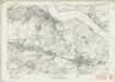
Essex nXCIV - OS Six-Inch Map
1 : 10560 Topographic maps Ordnance Survey Ordnance Survey
Essex nXCIV - OS Six-Inch Map
1 : 10560 Topographic maps Ordnance Survey Ordnance Survey
Essex LXXXIII - OS Six-Inch Map
1 : 10560 Topographic maps Ordnance Survey Ordnance Survey
Kent III - OS Six-Inch Map
1 : 10560 Topographic maps Ordnance Survey Ordnance Survey
TQ57 - OS 1:25,000 Provisional Series Map
1 : 25000 Topographic maps Ordnance Survey Ordnance Survey
Purfleet(002OSD000000006U00391000)
1 : 21120 .This is a very rough pencil and ink field sketch (known as a 'foul plan') of the north bank of the River Thames, running from Purfleet, at the bottom of the map, to Upminster, at the top. The Essex landscape was described on 10 pieces of irregularly cut thin paper and shows considerable mismatching along the joins. The more detailed fair drawing OSD 133 serial 390 covers the same area. This map was made in the field by the draughtsman to augment the angle and distance measurements recorded in the Ordnance Survey field books.
Purfleet(002OSD000000006U00390000)
1 : 21120 This fair plan describes the north bank of the River Thames from Purfleet and West Thurrock, at the bottom, to Upminster, at the top. The manuscript is covered with pencil rays. Radiating from trigonometrical stations, these were used for measuring and plotting topographical features. Field boundaries infilled with stripes depict cultivated land. Marshes and untilled agricultural land are identified by 'open dotting' at the bottom of the map.
A topographical-map, of the county of Kent, 2
1 Blatt : 54 x 69 cm A. Dury, W. Herbert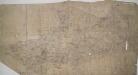
Dartford, Kent
Details of this drawing are corrected in heavy black ink with crosses placed over incorrect field boundaries and communication routes. Red pecked lines form a grid over the drawing. These are triangulation lines, which the draughtsman used to plot features of the landscape. A characteristically straight Roman road is shown leading from Dartford. In the bottom right, the scale is recorded and area calculations laid out.
Dartford (Hills) - OS One-Inch Revised New Series
1 : 63360 Topographic maps Ordnance Survey Ordnance Survey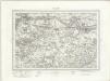
Dartford (Outline) - OS One-Inch Revised New Series
1 : 63360 Topographic maps Ordnance Survey Ordnance Survey
Die Environs von London
Londýn (Anglie) Kitchin, Thomas Bowles, Carington
London passenger transport map
Ordnance Survey
[Kaart], uit: S.E. London & Sevenoaks
1 : 64000 titelvariant: Ordnance Survey contoured road map of S.E. London and Sevenoaks; Annotatie: Omslagtitel: Ordnance Survey contoured road map of S.E. London and Sevenoaks Ordnance Survey Southampton : The Director General, at the Ordnance Survey Office
The Environs Of London.
1 : 95000 Colton, G.W.
London environs.
1 : 91500 Society for the Diffusion of Useful Knowledge (Great Britain)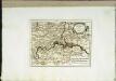
Die Gegend um London
1 Karte : Kupferdruck ; 20 x 26 cm Reilly F. J. J. von Reilly

Ordnance Survey of England and Wales (Sheet 7), South Wales
Ordnance Survey, Great Britain
England & Wales. Diagram of London
Ordnance Survey
London and Environs, Plate 55, V. III
1 : 100000 Bartholomew, John
Delineatio ac finitima regio Magnae Brittaniae metropoleos Londini
Londýn (Anglie) Seutter, Matthäus a Matt. Seutter
MAP of the COUNTRY 15 MILES ROUND London SHEWING BY A YELLOW CIRCLE OF 3 MILEs, THE LIMITS OF THE TWOPENNY POST DELIVERY
This map was commissioned by the House of Commons for the ninth report of the Post Office Management. The map's title features at top right, with an explanatory note and scale bar at bottom right. It shows the boundaries of the London Two-Penny Post, and the old and current boundaries of the Country Three-Penny Post, with mail routes highlighted in red. Post stages on the edges of the post area allowed mail to be exchanged between the London and the General Post on all main roads out of London. Wyld, James


