Maps of Sevenoaks

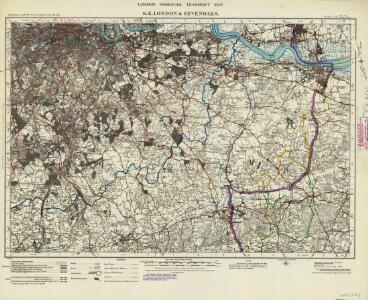
London passenger transport map
Ordnance Survey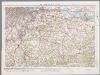
[Kaart], uit: S.E. London & Sevenoaks
1 : 64000 titelvariant: Ordnance Survey contoured road map of S.E. London and Sevenoaks; Annotatie: Omslagtitel: Ordnance Survey contoured road map of S.E. London and Sevenoaks Ordnance Survey Southampton : The Director General, at the Ordnance Survey Office
Dartford (Hills) - OS One-Inch Revised New Series
1 : 63360 Topographic maps Ordnance Survey Ordnance Survey
Dartford (Outline) - OS One-Inch Revised New Series
1 : 63360 Topographic maps Ordnance Survey Ordnance Survey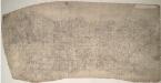
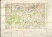
Sevenoaks (Kent) 16
This drawing records the field boundaries and woodland surrounding the towns of Sevenoaks and Kingsdown in Kent. Cultivated land is indicated by a striped pattern, purposely aping the furrows of actual tilled land. Precise instructions for the arrangement of these lines were given in the military manuals. For example, adjacent fields could not have stripes running in the same direction. An 'Old Roman Camp' is recorded on Ightham Common. Pink, George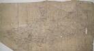
Dartford, Kent
Details of this drawing are corrected in heavy black ink with crosses placed over incorrect field boundaries and communication routes. Red pecked lines form a grid over the drawing. These are triangulation lines, which the draughtsman used to plot features of the landscape. A characteristically straight Roman road is shown leading from Dartford. In the bottom right, the scale is recorded and area calculations laid out.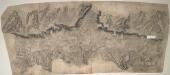
Beddlested (Kent)
Drawing showing the area around Beddlested in Kent. This sheet is made from several pieces of thin, irregularly cut paper joined together. As a result, the drawing is elongated and has a section missing. A line of dense interlining ('hachuring') along the centre of the map denotes a steep ridge. Written on the reverse of this drawing is "Rags of Kent Sketches by Geo. Pink Royal Military Surveying Draftsman 1789". This may be a retrospective inscription, as the RMSD were not formed until 1798. A Roman camp is shown in the left hand portion of the drawing. The recording of archaeological sites was not obligatory until 1816, but many draughtsmen showed their interest by recording them prior to this date. Pink, George
A topographical-map, of the county of Kent, 6
1 Blatt : 54 x 69 cm s.n.
Croydon
1 : 31680 Woodland and agricultural land dominate this plan, which covers an area from Beckenham and Croydon at the top, to Felbridge, Hackenham and Gotwick at the bottom. Buildings are infilled and blocked together at Croydon, the largest settlement shown.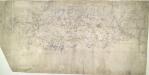
Eynsford (Kent)
This drawing, showing the area around Eynsford in Kent, is covered by a network of red rays, radiating from fixed points marking triangulation stations. These stations, usually sites of relative physical eminence, provided a framework within which to survey the topography of the land. On this plan, red lines radiate from the village church of Ash, marked by a red cross, and from an obelisk in Lullingstone Park. On the far left of the drawing, the word "flag" represents another triangulation point, from which the surveyor took angular measurements. Handwritten annotations at the bottom of the drawing refer to area measurements. There are some corrections in ink Pink, George
Bromley (Kent)
1 : 21120 Drawing showing the area around Bromley in Kent. Field boundaries enclosing cultivated land dominate this map of what is now south-east London. Such land is depicted by a striped pattern. Ruled dashed red lines also feature strongly. They radiate from trigonometrical stations used for measuring and plotting topographical features. The signalling telegraph station in Plow Garlic Hill at the top left of the plan marks the site of a trigonometrical station.
A topographical-map, of the county of Kent, No. 1
1 Blatt : 54 x 69 cm A. Dury, W. Herbert
Militärgeographische Angaben über England.
Generalstab des Heeres, Abteilung für Kriegskarten u. Vermessungswesen IV. Mil.-Geo
TQ57 - OS 1:25,000 Provisional Series Map
1 : 25000 Topographic maps Ordnance Survey Ordnance Survey
TQ56 - OS 1:25,000 Provisional Series Map
1 : 25000 Topographic maps Ordnance Survey Ordnance Survey
TQ47 - OS 1:25,000 Provisional Series Map
1 : 25000 Topographic maps Ordnance Survey Ordnance Survey
TQ46 - OS 1:25,000 Provisional Series Map
1 : 25000 Topographic maps Ordnance Survey Ordnance Survey
TQ37 - OS 1:25,000 Provisional Series Map
1 : 25000 Topographic maps Ordnance Survey Ordnance Survey
TQ36 - OS 1:25,000 Provisional Series Map
1 : 25000 Topographic maps Ordnance Survey Ordnance Survey
TQ35 - OS 1:25,000 Provisional Series Map
1 : 25000 Topographic maps Ordnance Survey Ordnance Survey
TQ45 - OS 1:25,000 Provisional Series Map
1 : 25000 Topographic maps Ordnance Survey Ordnance Survey
TQ55 - OS 1:25,000 Provisional Series Map
1 : 25000 Topographic maps Ordnance Survey Ordnance Survey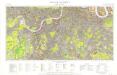
Great Britain [Second land utilisation survey] 1:25,000
Coleman, Alice Isle of Thanet Geographical Association
TQ66 - OS 1:25,000 Provisional Series Map
1 : 25000 Topographic maps Ordnance Survey Ordnance Survey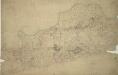
Woolwich
1 : 21120 This drawing covers the south bank of the River Thames from Deptford to Erith. Pencil and red ink rays extending from fixed points are clearly visible on the manuscript, and were used to plot the survey of the area. The numbers 1 to 7 in red ink across the map indicate the position from which field sketches were taken. Buildings are infilled and blocked in red at settlements like Woolwich and Greenwich. Clearly indicated is the Woolwich Warren, site of naval shipbuilding since the early-16th century. Before the Royal Arsenal was officially established there in 1805, the Warren had been home of military armsworks for more than a century.
TQ67 - OS 1:25,000 Provisional Series Map
1 : 25000 Topographic maps Ordnance Survey Ordnance Survey
A topographical-map, of the county of Kent, 7
1 Blatt : 54 x 71 cm A. Dury, W. Herbert
TQ65 - OS 1:25,000 Provisional Series Map
1 : 25000 Topographic maps Ordnance Survey Ordnance Survey
MILNE'S PLAN of the CITIES of LONDON and WESTMINSTER, circumjacent TOWNS and PARISHES &c. laid down from a TRIGONOMETRICAL SURVEY taken in the YEARS 1795-1799
This is one of six sheets forming Milne's map of the area twenty miles around London. It was the first to make use of the 'Trygonometrical Survey' founded in 1791. This sheet covers the area to the west and south-west of the capital. It shows all the field boundaries and indicates land use with a complex system of letters and colours. The key is featured on the top corners. The borders of the map are divided in minutes and seconds, giving scale, angles of observations and magnetic variations. Thomas Milne trained as an estate surveyor and worked on the first Ordnance Survey map of Kent. Milne, Thomas