Maps of London

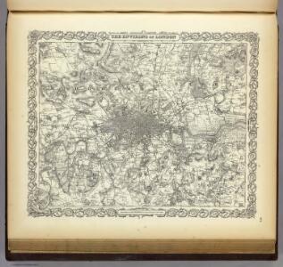
The Environs Of London.
1 : 95000 Colton, G.W.
London environs.
1 : 91500 Society for the Diffusion of Useful Knowledge (Great Britain)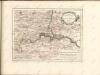

England & Wales. Diagram of London
Ordnance Survey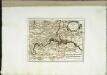
Die Gegend um London
1 Karte : Kupferdruck ; 20 x 26 cm Reilly F. J. J. von Reilly
London and Environs, Plate 55, V. III
1 : 100000 Bartholomew, John
MAP SHEWING THE SEVERAL WALKS OR DELIVERIES IN THE COUNTRY DISTRICTS OF THE TWO PENNY POST, With the Rides to which they are attached numbered to correspond with the figure in the accompanying List
This map was commissioned by the House of Commons for the21st report of the Commissioners of Revenue Inquiry. It title features at top right, with its border divided in degrees of latitude and longitude. Rides and delivery walks in the Two-Penny Country Post are highlighted in colour and numbered for reference. A list of rides and key to delivery walks appears in a table at bottom right. Arrowsmith, Aaron
Fairburn’s Map of the Country twelve miles round London. Second Edition
Fairburn, John London
Delineatio ac finitima regio Magnae Brittaniae metropoleos Londini
Londýn (Anglie) Seutter, Matthäus a Matt. Seutter
Die Environs von London
1 : 470000 Londýn (Anglie)
Geological map London.
1 : 90000 Letts, Son & Co.
Orographical map London.
1 : 90000 Letts, Son & Co.
Official railway map of London and its environs
1 : 33000 J. & W. Emslie Railway Clearing House
Die Environs von LONDON
Londýn (Anglie)
Die Environs von London
Londýn (Anglie) Landes Industrie Comptoirs
Environs of London.
1 : 95000 Colton, G.W.
The M.P. atlas
Edinburgh : W. & A.K. Johnston,
Environs of London.
Colton, G.W.
London.
1 : 95000 Colton, G.W.
London, England.
1 : 1500000 Colton, G.W.
How to travel in and around London by railway
London : M. Vigers
London and its environs : containing the boundaries of the metropolitan boroughs, the different railroads & stations, the new cemeteries, roads, docks, canals, and all the modern improvements : this map is chiefly from the Ordinance Survey, the railroads and other improvements are from the official copies, the boroughs of Marylebone from the survey published by M.r Britton, the whole corrected from personal observation & measurement
1 : 42000 Davies, Benjamin Rees C. F. Cheffins, lithog ; Wm. S. Orr & Co. ; Letts & Son ; J. Cross & Son ; T.W. Saunders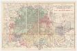
Map of London and its environs : shewing the boundary of the jurisdiction of the metropolitan board of work, also the boundaries of the city of London : Gas companies’ districts
1 : 31680 Standford, Edward, 1827-1904 Edward Standford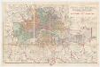
Map of London and its environs : shewing the boundary of the jurisdiction of the metropolitan board of work, also the boundaries of the city of London : Parliamentary boroughs
1 : 31680 Standford, Edward, 1827-1904 Edward Standford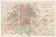
Map of London and its environs : shewing the boundary of the jurisdiction of the metropolitan board of work, also the boundaries of the city of London : Water companies’ district
1 : 31680 Standford, Edward, 1827-1904 Edward Standford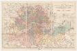
Map of London and its environs : shewing the boundary of the jurisdiction of the metropolitan board of work, also the boundaries of the city of London : Poor law unions
1 : 31680 Standford, Edward, 1827-1904 Edward Standford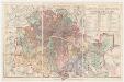
Map of London and its environs : shewing the boundary of the jurisdiction of the metropolitan board of work, also the boundaries of the city of London : Parishes the districts & extra parochial places
1 : 31680 Standford, Edward, 1827-1904 Edward Standford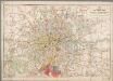
[Kaart], uit: Bartholomew's road surface map of London & neighbourhood
1 : 30000 Edinburgh : Bartholomew
[Recto], uit: Route map and guide : [London]
1 : 50000 London : London General Omnibus Co.