Maps of New York

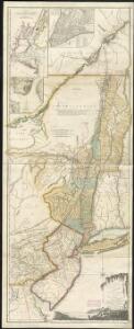
The provinces of New York and New Jersey, with part of Pensilvania, and the Province of Quebec
1 : 650000 Pownall, Thomas Robert Sayer & John Bennett (Firm)
The provinces of New York, and New Jersey : with part of Pensilvania and the province of Quebec / drawn by Major Holland, Surveyor General of the Northern District in America ; corrected and improved, from the original materials, by Governr. Pownall, Mem
from Charts and maps
The provinces of New York, and New Jersey; with part of Pensilvania, and the province of Quebec
1 : 700000 drawn by major Holland, surveyor general, of the Northern district in America corrected and improved from the original materials by govern.r Pownall, member of parliament London : printed for Rob.t Sayer & John Bennett [...]
Rome, Watertown and Ogdensburg Railroad.
1 : 5514850 Rome, Watertown & Ogdensburg Railroad Company
The Provinces of New York, and New Jersey; with part of Pensilvania.
1 : 633600 Jefferys, Thomas
A chorographical map of the province of New-York in North America, divided into counties, manors, patents and townships : exhibiting likewise all the private grants of land made and located in that Province / compiled from actual surveys deposited in the
from Whole
New York.
1 : 3674880 Scott, Joseph
New York.
1 : 2787840 Morse, Jedidiah
A map of the state of New York / J. Roper, sc.
J. Roper,
Mappa geographica Provinciae Novae Eboraci ab Anglis New-York dictae / ex ampliori delineatione ad exactas dimensiones concinnata in arctius spatium redacta cura Claudii Josephi Sauthier cui accedit Nova Jersey ex topographicis observationibus.
from Charts and maps Claude Joseph Sauthier,
Map of the state of New York / by Simeon De Witt, surveyor general ; engraved by G. Fairman.
from Whole
Shell Highway Map of New York (western portion).
1 : 792000 Shell Oil Company
A chorographical map of the province of New-York in North America, divided into counties, manors, patents and townships.
from Whole
A new and accurate map of the province of New York and part of the Jerseys, New England and Canada: shewing the scenes of our military operations during the present war: also the new erected state of Vermont / Jn. Lodge, sculp.
from (A-Z) John Lodge,,
New York.
1 : 570000 Rand McNally and Company
A chorographical map of the Province of New-York in North America, divided into counties, manors, patents and townships, exhibiting likewise all the private grants of land made and located in that Province
1 : 322000 Sauthier, Claude Joseph Faden, William
A new and accurate map of the province of New York and part of the Jerseys, New England and Canada, shewing the scenes of our military operations during the present war, also the new erected state of Vermont

A map of the provinces of New-York and New Jersey, with a part of Pennsylvania and the Province of Quebec
1 : 1040000 Sauthier, Claude Joseph Lotter, Matthäus Albrecht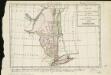
Carte de la Nouvelle York, y-compris les terres cédées du N. Hamp-Shire, sous le nom d'etat de Vermont
1 : 2500000 Hilliard d'Auberteuil, Michel René
Map of the state of New York / by Simeon De Witt, surveyor general; engraved by G. Fairman.
from Charts and maps Simeon De Witt; G. Fairman,
State of New York with part of the adjacent States.
1 : 633600 Eddy, John H.
State of New York.
1 : 300000 French, C.E.
An Accurate map of New York in North America, from a late survey.
from John H. Levine Collection J. (John) Hinton: [London],
Pensylvania Nova Jersey et Nova York cum Regionibus ad Fluvium Delaware in America sitis
1 : 1000000 Lotter, Tobias Conrad
A map of the State of New York
1 : 950000 De Witt, Simeon
The provinces of New York, and New Jersey: with part of Pensilvania and the province of Quebec / drawn by Major Holland, Surveyor General of the Northern District in America; corrected and improved, from the original materials, by Governr. Pownall, Member of Parliament; Hen. Contger, sculp. mog.
from Charts and maps Samuel Holland; Governrnor Pownall,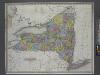
New York / by H.S. Tanner.
from Whole Henry S. Tanner,
The Empire State, New York: with its counties, towns, cities, villages, internal improvements &c. / drawn & engraved by J. H. Young.
from Whole J. H. Young,
Map of the state of New York: showing the boundaries of counties & townships, the location of cities, towns and villages, the courses of rail roads, canals & stage roads / by J. Calvin Smith; engraved on steel by Sherman & Smith.
from Whole J. Calvin Smith; Sherman & Smith,
Map of the state of New York: showing the boundaries of counties & townships, the location of cities, towns and villages, the courses of rail roads, canals & stage roads / by J. Calvin Smith; engraved on steel by Sherman & Smith.
from Whole J. Calvin Smith; Sherman & Smith,
New York / by H.S. Tanner; engraved ... by H.S. Tanner.
from Whole Henry S. Tanner,
The state of New York from the most recent surveys.
from Whole Published by E. Huntington: Hartford, Conn.; Huntington, Eleazar,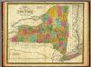
State of New York.
1 : 1330560 Mitchell, Samuel Augustus
The tourist's map of the state of New York: compiled from the latest authorities in the Surveyor General's office / engraved by Balch, Stiles & Co., N. York.
from Whole Balch, Stiles & Co.,,
Map of the state of New-York with part of the states of Pennsylvania, New-Jersey, &c. / compiled, corrected & published from the most recent authorities and accurate surveys by Amos Lay, 1817.
from Parts Amos Lay,
New York.
1 : 2700000 Lewis, Samuel