Maps of Adirondack Mountains

The Provinces of New York, and New Jersey; with part of Pensilvania.
1 : 633600 Jefferys, Thomas
The provinces of New York, and New Jersey; with part of Pensilvania, and the province of Quebec
1 : 700000 drawn by major Holland, surveyor general, of the Northern district in America corrected and improved from the original materials by govern.r Pownall, member of parliament London : printed for Rob.t Sayer & John Bennett [...]
The provinces of New York and New Jersey, with part of Pensilvania, and the Province of Quebec
1 : 650000 Pownall, Thomas Robert Sayer & John Bennett (Firm)
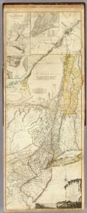
The provinces of New York, and New Jersey: with part of Pensilvania, and the governments of Trois Rivieres, and Montreal / drawn by Capt. Holland; engraved by Thomas Jefferys, geographer to His Majesty.
from Charts and maps Thomas Jefferys; Samuel Holland,
The provinces of New York, and New Jersey: with part of Pensilvania and the province of Quebec / drawn by Major Holland, Surveyor General of the Northern District in America; corrected and improved, from the original materials, by Governr. Pownall, Member of Parliament; Hen. Contger, sculp. mog.
from Charts and maps Samuel Holland; Governrnor Pownall,
The provinces of New York, and New Jersey : with part of Pensilvania and the province of Quebec / drawn by Major Holland, Surveyor General of the Northern District in America ; corrected and improved, from the original materials, by Governr. Pownall, Mem
from Charts and maps
Map Central Vt. RR.
1 : 3509000 Central Vermont Railroad Company
Carte du théatre de la guerre entre les Anglais et les Américains dressée d'après les cartes anglaises les plus modernes, / par M. Brion de la Tour, ingr. géographe du Roi.
from Charts and maps M. Bellin,
Carte du théatre de la guerre entre les Anglais et les Américains: dressée d'après les cartes anglaises les plus modernes / par M. Brion de la Tour, ingénieur-geógraphe du Roi.
from Charts and maps M. Bellin,
A new and accurate map of the province of New York and part of the Jerseys, New England and Canada, shewing the scenes of our military operations during the present war, also the new erected state of Vermont

A chorographical map of the province of New-York in North America, divided into counties, manors, patents and townships : exhibiting likewise all the private grants of land made and located in that Province / compiled from actual surveys deposited in the
from Whole
A chorographical map of the province of New-York in North America, divided into counties, manors, patents and townships.
from Whole
New York.
1 : 2787840 Morse, Jedidiah
A map of the state of New York / J. Roper, sc.
J. Roper,
A new and accurate map of the province of New York and part of the Jerseys, New England and Canada: shewing the scenes of our military operations during the present war: also the new erected state of Vermont / Jn. Lodge, sculp.
from (A-Z) John Lodge,,
A chorographical map of the Province of New-York in North America, divided into counties, manors, patents and townships, exhibiting likewise all the private grants of land made and located in that Province
1 : 322000 Sauthier, Claude Joseph Faden, William
Map of the state of New York / by Simeon De Witt, surveyor general ; engraved by G. Fairman.
from Whole
Map of the state of New York / by Simeon De Witt, surveyor general; engraved by G. Fairman.
from Charts and maps Simeon De Witt; G. Fairman,
Shell Highway Map of New York (western portion).
1 : 792000 Shell Oil Company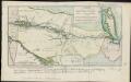
Carte de la route des lacs depuis Montréal et St. Jean jusqu'à la Riviere d'Hudson réduite d'après les meilleures cartes anglais e[s], pour servir aux Essais historiques et politiques sur la révolution de l'Amérique septentrionale
1 : 475200 Hilliard d'Auberteuil, Michel René
A map of the provinces of New-York and New Jersey, with a part of Pennsylvania and the Province of Quebec
1 : 1040000 Sauthier, Claude Joseph Lotter, Matthäus Albrecht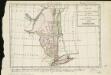
Carte de la Nouvelle York, y-compris les terres cédées du N. Hamp-Shire, sous le nom d'etat de Vermont
1 : 2500000 Hilliard d'Auberteuil, Michel René
New York.
1 : 570000 Rand McNally and Company
The provinces of New York, and New Jersey : with part of Pensilvania, and the governments of Trois Rivieres, and Montreal / drawn by Capt. Holland ; engraved by Thomas Jefferys, geographer to His Majesty.
from Parts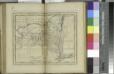
New York / W. Barker, sculp.; Carey's American pocket atlas; containing nineteen maps... with a brief description of each state.
from Carey's American pocket atlas; containing nineteen maps... with a brief description of each state. Carey, Mathew; Sweitzer, Henry,
An Accurate map of New York in North America, from a late survey.
from John H. Levine Collection J. (John) Hinton: [London],
Map of Hudson's River, with the adjacent country.
from Hudson River for D. Henry: [London],
New York (eastern section).
1 : 570000 Rand McNally and Company
North America 1:1,000,000
1 : 1000000 Hudson (New York a New Jersey : řeka : oblast) United States Geological survey