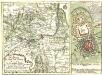
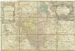
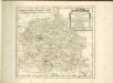
Meßtischblatt 5571 : Friedland O.S., 1941
1 : 250000
Friedland O.S. - Aufn. 1883, hrsg. 1884, bericht. 1937, Nachtr. 1939, Ausg. 1941. - 1:25000. - [Berlin]: Reichsamt für Landesaufnahme, 1941. - 1 Kt.

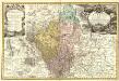
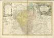
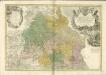
171 Neisse, uit: Topographische Special-Karte von Deutschland (von Central-Europa) / begründet von D.G. Reymann ; [entworfen und gezeichn. von Heinrich Berghaus... [et al.]]
1 : 200000
Annotatie: Lit.: Daniel Gottlob Reymann und die "Topographische Special-Karte von Deutschland" / von Wolfgang Scharfe, in: Kartographische Nachrichten, 39 (1989), Heft I, p. 1-10; Handgeschreven titel: Reymann's Deutschland : 24 Sectionen: Jena, Penig, Dresden, Zittau, Hirschberg, Breslau, Brieg, Andernach, Coblenz, Giessen, Fulda, Schleusingen, Plauen, Zwickau, Teplitz, Jung Bunzlau, Hohenelbe, Glatz, Neisse, Simmern, Prag, Luxemburg, Birkenfeld; Aanwezig: 23 bladen
Reymann, Daniel Gottlob; Berghaus, Heinrich
[Berlin : 2. Departement des Kriegsministeriums, Bureau für Plan- und Kartenzeichnung]
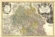
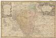
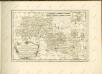
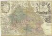
Principatvs Silesiae Oppoloniensis exactissima Tabula geographica, sistens Circvlos Oppoloniensem Ober-Glogav Gros Strehliz, Cosel, Tost, Rosenberg, Falckenberg & Lvblenitz.
1 : 216000
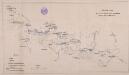
Mollova mapová sbírka
Wieland, Johann Wolfgang
Homann, Johann Baptista - dědici