Maps of Olomoucký

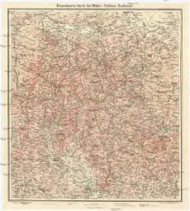
Reisekarte durch die Mähr.-Schles.-Sudeten
1 : 200000 Jeseníky (Česko : pohoří) A. Blažek
Das deutsche Sprachgebiet Nord-Mährens u. Schlesiens auf Grand der Volkszählung v. 31. Dec. 1880
1 : 300000 Morava severní (Česko) Held, Franz Wolfschütz Historisch-statistische Section der k. k. mährisch-schlesische Ackerbaugesellschaft
Olmütz 105, uit: Special-Karte von Mittel-Europa / nach amtlichen Quellen bearbeitet von W. Liebenow
1 : 300000 titelvariant: W. Liebenow's Mittel-Europa; Annotatie: Titel boven de bladen: W. Liebenow's Mittel-Europa Johannes Wilhelm Liebenow 1822-1897 Frankfurt a. M. : Ludwig Ravenstein
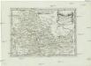
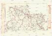
Troppauer Kreis

[Die Markgraftschaft Mähren]
1 : 200000 Opava-oblast (Česko) Schenkl, Conrad Philipp Carl Winiker
Der Troppauer Kreis
1 : 200000 Jeseníky (Česko) Schenkl, Conrad Philipp Carl Winiker
Přehledná mapa katastrálních území ve Slezsku
Mapa dekanátů, poutních míst a klášterů vévodství slezského
Slezsko (Česko)
Slezská silniční mapa
Der Markgrafschaft Maehren
1 : 670000 Branná (Šumperk, Česko)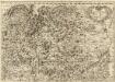
Tabula Generalis Marchionatus Moraviae in sex circulos divisae]
1 : 183000 Mollova mapová sbírka Müller, Johann Christoph Gastl, Jan Jiří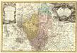
Principatvs Silesiae Grotkani exactissima Tabula geographica exhibens Terram Nissensem simul ac Circulos Grotkau Ottmuchau, et Ziegenhals.
1 : 154000 Mollova mapová sbírka Wieland, Johann Wolfgang Homann, Johann Baptista - dědici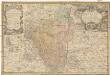
Principatvs Silesiae Grotkani exactissima tabula geographica exhibens terram Nissensem simul ac circulos Grotkau, Ottmuchau, et Ziegenhals
1 : 154000 Gródkow (Polsko) Wieland, Johann Wolfgang Schubarth, Matthäus ab Haeredibus Homannianis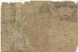
Principatvs Silesiae Grotkani exactissima tabula geographica exhibens terram Nissensem simul ac circulos Grotkau Ottmuchau, et Ziegenhals
1 : 154000 Gródkow (Polsko) Wieland, Johann Wolfgang Schubarth, Matthäus Homannianos Heredes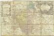
Principatvs Silesiae Grotkani exactissima tabula geographica exhibens terram Nissensem simul ac circulos Grotkau Ottmuchau, et Ziegenhals
1 : 154000 Gródkow (Polsko) Wieland, Johann Wolfgang Schubarth, Matthäus Haeredibus Homannianis
[Circuli Olomucensis pars borealis]
1 : 150000 Morava (Česko) Müller, Johann Christoph
Circuli Olomucensis pars borealis
1 : 150000 Morava (Česko) Müller, Johann Christoph
Přehledná mapa panství biskupství Vratislavského v Československé republice podle stavu ke dni 1. ledna 1929
1 : 75000 Vratislav-oblast (Polsko) Bauer, E. Vojenský zeměpisný ústav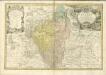

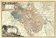
Marchionatus Moraviae Circulus Olomucensis pars Borealis

Karte von Olmützer-Kreise des Markgrafthumes Maehren
1 : 145000 Olomouc-oblast (Česko) Liechtenstern Eduard Hölzet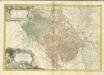
Komunikační mapa země Moravskoslezské
1 : 100000 Jeseník (Česko : oblast) Morslez. zem. výbor
Moravská část území župy olomoucké
Olomouc-oblast (Česko) Lepař, Jan Raffelsperger, Franz nakladatelství R. Promberga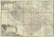
Principatvs Silesiae Oppaviensis novissima tabula geographica
1 : 150000 Opava-oblast (Česko) Wieland, Johann Wolfgang Schubarth, Matthäus Homannianos Heredes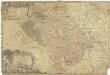
Principatvs Silesiae Oppaviensis novissima tabula geographica
1 : 150000 Opava-oblast (Česko) Wieland, Johann Wolfgang Schubarth, Matthäus Homannianos Heredes
Moravská část území župy Olomoucké
Principatvs Silesiae Oppaviensis novissima Tabula geographica.
1 : 150000 Mollova mapová sbírka Wieland, Johann Wolfgang Homann, Johann Baptista - dědici
Jeseníky