Maps of powiat nyski
Operations Charte für die ersten Ereignisse des Feldzuges von 1761 in Schlesien
1 : 400000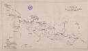
Übersichts Charte de Winterquartiere der beiden Armeen an der böhmisch-schlesischen Grenze im Winter 1760/61
1 : 600000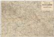
Karte vom Riesen-Gebirge und Grafschaft Glatz
1 : 250000 Kladsko-oblast (Polsko) Albert Goldschmidt
Karte der Umgegend von Gräfenberg
1 : 110000 Lázně Jeseník (Česko) Hennings, Th. Th. Hennings
Neisse 91, uit: Special-Karte von Mittel-Europa / nach amtlichen Quellen bearbeitet von W. Liebenow
1 : 300000 titelvariant: W. Liebenow's Mittel-Europa; Annotatie: Titel boven de bladen: W. Liebenow's Mittel-Europa Johannes Wilhelm Liebenow 1822-1897 Frankfurt a. M. : Ludwig Ravenstein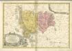

133. Schweidnitz, uit: Topographische Uebersichtskarte des Deutschen Reiches / herausgegeben v. d. Kartogr. Abt. d. Königl. Preuß. Landesaufnahme
1 : 200000 titelvariant: Topogr. Übersichtskarte des Deutschen Reiches; Annotatie: Titel boven bladen ook: Topogr. Übersichtskarte des Deutschen Reiches; Annotatie geografische gegevens: Op elk blad twee maatstokken: 10 Kilometer = 5,5 cm; 1 geogr. Meile = 3,6 cm; Legenda onder op elk blad Königlich Preußische Landesaufnahme. Kartographische Abtheilung [S.l : Königlich Preußische Landesaufnahme, Kartographische Abtheilung]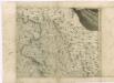
Müllerova mapa Čech
1 : 132000
Monumenta Cartographica Bohemiae II.: Müllerova mapa

Sbírka map a diagramů použitých na mírových konferencích v Paříži v letech 1919 - 1920

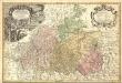
Dvcatvs Silesiae Schwidnicensis
1 : 172500 Mollova mapová sbírka Kuhn, Friedrich Schenk, Peter I
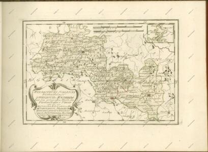
Ducatus Silesiae Grotganus cum Districtu Episcopali Nissensi [Karte], in: Novus atlas absolutissimus, Bd. 2, S. 270.
1 Karte aus Atlas Janssonius Offizin
DVCATVS | SILESIÆ | SCHWIDNICENSIS
Authore Friduico Kuhnovio | Bolco-lucano Silesio. [Amsterdam : Joan Blaeu]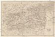
Special Karte der Grafschaft Glatz nebst angrenzenden Theilen von Böhmen und Mähren etc
1 : 150000 Kladsko-oblast (Polsko) Liebenow, W. Eduard Trewendt
170 Glatz, uit: Topographische Special-Karte von Deutschland (von Central-Europa) / begründet von D.G. Reymann ; [entworfen und gezeichn. von Heinrich Berghaus... [et al.]]
1 : 200000 Annotatie: Lit.: Daniel Gottlob Reymann und die "Topographische Special-Karte von Deutschland" / von Wolfgang Scharfe, in: Kartographische Nachrichten, 39 (1989), Heft I, p. 1-10; Handgeschreven titel: Reymann's Deutschland : 24 Sectionen: Jena, Penig, Dresden, Zittau, Hirschberg, Breslau, Brieg, Andernach, Coblenz, Giessen, Fulda, Schleusingen, Plauen, Zwickau, Teplitz, Jung Bunzlau, Hohenelbe, Glatz, Neisse, Simmern, Prag, Luxemburg, Birkenfeld; Aanwezig: 23 bladen Reymann, Daniel Gottlob; Berghaus, Heinrich [Berlin : 2. Departement des Kriegsministeriums, Bureau für Plan- und Kartenzeichnung]
Proskoumání Čech Sekce III.

DVCATVS SILESIÆ | GROTGANVS | cum Districtu Episcopali | NISSENSI
Amstelædami J. Blaeu excudit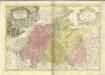

Comitatus Glaciensis

Kladsko
1 : 200000 Kladsko-oblast (Polsko) Service cartogr. de l ́Armee Tcheco-Sl.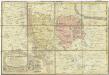
Principatvs Silesiae Mvnsterbergensis exactissima tabula geographica exhibens circulos ejusdem Mvnsterberg et Frankenstein una cum adjacentibus civitatibus Reichenstein et Silberberg ad principatum bregensem alias pertinentibus
1 : 100000 Slezsko Wieland, Johann Wolfgang Schubarth, Matthäus Homannianos Heredes
Comitatus Glaciensis tabula geogr
1 : 160000 Kladsko-oblast (Polsko) Mayer, Tobias edentibus Homannianis Heredibus
Comitatus Glaciensis tabula geogr
1 : 150000 Kladsko-oblast (Polsko) Mayer, Tobias Homannianos Heredes
Comitatus Glaciensis tabula geogr
1 : 160000 Kladsko-oblast (Polsko) Mayer, Tobias edentibus Homannianis Heredibus
Comitatus Glatz [Karte], in: Novus atlas absolutissimus, Bd. 2, S. 247.
1 Karte aus Atlas Janssonius Offizin
[A. Bidschover und B. Königingratzer Kreis samt der Grafschaft Glatz]
1 : 175000 Hradec Králové-oblast (Česko) Franza, Petr Peter franza [sic]
A. Bidschover und B. Königingratzer Kreis samt der Grafschaft Glatz
1 : 175000 Hradec Králové-oblast (Česko)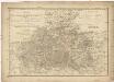
Das Fürstenthum Schweidnitz
1 : 130000 Slezsko Sotzmann, Daniel Friedrich Fembo, Christoph Christoph Fembo