Maps of Aosta Valley

Atlas Suisse
1 : 120000 16 Karten levé et dessiné par J.H. Weiss [et Joachim Eugen Müller] aux frais de J.R. Meyer à Aarau dans les années 1786 à 1802 ; gravée [sic] par [Christophe] Guérin, [Matthias Gottfried] Eichler et [Johann Jakob] Scheurmann [Johann Rudolf Meyer], Aarau
Partie du c.ton du Vallais et le versant des eaux du Piemont
1 : 108000 Weiss, Johann Heinrich ; Guérin, Christophe ; Meyer, Johann Rudolf J. R. Meyer
Environs de la Boneville et de Martinach
1 : 240000 Mollova mapová sbírka Dheulland, Guillaume Dheulland, Guillaume
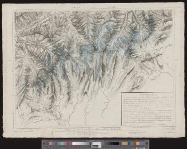
Karte der Thäler von Bagne, Nendaz u. Hérémence im Wallis
1 : 300000 1 Karte G. St. Topogr. Anstalt v. J. Wurster u. Comp., [Winterthur]

Wandkarte der Schweiz
1 : 200000 1 Karte auf 8 Blättern J.M. Ziegler Wurster, Winterthur
Aosta
1 : 200000 Herder, Bartholomew
Valesiae Altera et VII. Nova Tabula. [Karte], in: Claud. Ptolemaeus. Geographia lat. cum mappis [...], S. 356.
1 Karte aus Atlas Münster, Sebastian [und Ptolemaeus, Claudius]
Carte du païs de Vallais, ou Wallisser-land
1 Karte : Kupferdruck ; 35 x 44 cm Valck; Schenk; Duval apud G. Valk et P. Schenk
Zermatt, Mte. Rosa
1 Vogelschaukarte Orell Füssli, Zürich
Karte über einen Theil der südlichen Wallisthäler
1 : 100000 1 Karte frei gezeichnet nach topogr. Skitzen ... von G. Studer 1849 Heinrich Fuessli u. Comp. zur Meisen, Zürich
Martigny, Aoste
1 : 100000 1 Karte geologische Aufnahme von H. Gerlach [Wurster & Randegger], [Winterthur]
Karte über einen Theil der südlichen Wallisthäler
1 : 100000 Studer, Gottlieb Henry Heinrich Fuessli u. Comp. zur Meisen
Topographische Karte der Schweiz
1 : 100000 25 Karten vermessen und hrsg. auf Befehl der Eidgenössischen Behörden ; aufgenommen unter der Aufsicht des Generals G.H. Dufour Eidg. Topographisches Bureau, [Genève], [später: Bern]

Rhodani progressus per Vallesiam
1 : 100000 1 Karte juxta observationes proprias factas in Itinere Alpino a Joanne Jacobo Scheuchzero sumptibus Petri vander Aa, Lugd. Bat. [i.e. Leiden]
Blatt XXII: Martigny, Aoste, uit: Topographische Karte der Schweiz / vermessen und hrsg. ... unter Aufsicht des Generals G.H. Dufour
1 : 100000 Annotatie: Met plaatsnamenregister (bl. V), bladwijzer (bl. XXI) en hoogteregister (bl. XXV); Voor aanwezige bladen zie overzichtsblad Dufour, G. H. [Bern : Eidg. Topogr. Bureau]
Sierre, Brig
1 Vogelschaukarte Orell Füssli, Zürich
Rhodani progressus per Vallesiam
1 : 100000 1 Karte a Joanne Jacobo Scheuchzero sumptibus Petri vander Aa, Lugd. Bat. [i.e. Leiden]
Topographische Karte der Schweiz
1 : 100000 25 Karten vermessen und hrsg. auf Befehl der Eidgenössischen Behörden ; aufgenommen unter der Aufsicht des Generals G.H. Dufour Eidg. Topographisches Bureau, [Genève], [später: Bern]
Blatt XXIII: Domo d'Ossola, Arona, uit: Topographische Karte der Schweiz / vermessen und hrsg. ... unter Aufsicht des Generals G.H. Dufour
1 : 100000 Annotatie: Met plaatsnamenregister (bl. V), bladwijzer (bl. XXI) en hoogteregister (bl. XXV); Voor aanwezige bladen zie overzichtsblad Dufour, G. H. [Bern : Eidg. Topogr. Bureau]
Bez titulu: Alpy

[Monte Rosu und Umgebung]
1 : 250000 Alpy italské (pohoří) Wagner & Debes
<<Le>> Val d'Anniviers
1 : 100000 1 Karte Topogr. Anst. v. Wurster, Randegger & Co. Justus Perthes, Gotha
[Kaart], uit: Theodulpass
1 : 50000 Bern : Schweizerische Landestopographie
Aosta
1 : 50000 Aosta (Itálie)
Col du Gd. St. Bernard
1 : 50000 Service topographique fédéral
Süd-Wallis
1 : 50000 8 Karten Topogr. Anstalt v. Wurster, Randegger & Co. ; gestochen von R. Leuzinger Topogr. Anstalt v. Wurster, Randegger & Co., Winterthur
Il Cervino e il Monte Rosa
1 : 50000 Penninské Alpy (Itálie a Švýcarsko : pohoří) Touring club Italiano