Maps of Zermatt

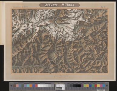
Zermatt, Mte. Rosa
1 Vogelschaukarte Orell Füssli, Zürich
Partie du c.ton du Vallais et le versant des eaux du Piemont
1 : 108000 Weiss, Johann Heinrich ; Guérin, Christophe ; Meyer, Johann Rudolf J. R. Meyer
Domo d'Ossola, Arona
1 : 100000 1 Karte geolog. Aufnahmen von H. Gerlach [Wurster & Randegger], [Winterthur]
[Kaart], uit: Theodulpass
1 : 50000 Bern : Schweizerische Landestopographie
[Monte Rosu und Umgebung]
1 : 250000 Alpy italské (pohoří) Wagner & Debes
Il Cervino e il Monte Rosa
1 : 50000 Penninské Alpy (Itálie a Švýcarsko : pohoří) Touring club Italiano
Süd-Wallis
1 : 50000 8 Karten Topogr. Anstalt v. Wurster, Randegger & Co. ; gestochen von R. Leuzinger Topogr. Anstalt v. Wurster, Randegger & Co., Winterthur
M[on]te Rosa
1 : 50000 Penninské Alpy (Itálie a Švýcarsko : pohoří) A. Vallardi
Süd-Wallis
1 : 50000 8 Karten Topogr. Anstalt v. Wurster, Randegger & Co. ; gestochen von R. Leuzinger Topogr. Anstalt v. Wurster, Randegger & Co., Winterthur
[Kaart], uit: Carte d'excursions de Zermatt
1 : 50000 Annotatie: Omslagtitel in het Duits en Frans, toeristische informatie in het Duits; Verso: toeristische informatie en hotels Seiler Zürich : Hofer & Co
Carte d'excursions de Zermatt
1 : 50000 Hofer & Co.
<<Die>> Gebirgsgruppe von der Pointe de Graffeneire (Gd. Combin) bis zum Mont Colon
1 : 50000 1 Karte auf 2 Blättern Topogr. Anstalt v. Wurster, Randegger & Co., [Winterthur]
<<Die>> Mt. Blanc de Cheillon und Mt. Colon-Gruppe nach den eidgenössischen Aufnahmen
1 : 50000 1 Karte Topogr. Anstalt v. Wurster, Randegger & Co. [Verlag nicht ermittelbar], [Erscheinungsort nicht ermittelbar]
Süd-Wallis
1 : 50000 8 Karten Topogr. Anstalt v. Wurster, Randegger & Co. ; gestochen von R. Leuzinger Topogr. Anstalt v. Wurster, Randegger & Co., Winterthur
Reliefkarte des Saas- und Monte Morogebietes
1 : 50000 1 Karte nach den Blättern 534 u. 536 des Siegfried Atlasses bearbeitet von R. Leuzinger ; Eidg. topogr. Bureau 1881 ; Topogr. Anst. v. Wurster, Randegger & Cie. [Verlag der Expedition des Jahrbuches des S.A.C.], [Bern]
Carte géologique de la région du Grand Combin
1 : 50000 Penninské Alpy (Itálie a Švýcarsko : pohoří) Argand, Emile A. Francke
Monte Cervino e conca del Breil
1 : 20000 Istituto geografico militare
Atlas Suisse
1 : 120000 16 Karten levé et dessiné par J.H. Weiss [et Joachim Eugen Müller] aux frais de J.R. Meyer à Aarau dans les années 1786 à 1802 ; gravée [sic] par [Christophe] Guérin, [Matthias Gottfried] Eichler et [Johann Jakob] Scheurmann [Johann Rudolf Meyer], Aarau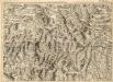
Environs de la Boneville et de Martinach
1 : 240000 Mollova mapová sbírka Dheulland, Guillaume Dheulland, Guillaume
Distanzenkarte von der Schweiz
1 : 200000 1 Karte in 8 Teilen nach den besten Hülfsquellen bearb. von R. Huber Wagner, Bern
Les Estats de Savoye et de Piémont le Dauphiné, la Bresse Partie du Lionnois et de la Provence.
1 : 250000 Mollova mapová sbírka Jaillot, Alexis-Hubert Jaillot, Alexis Hubert
Wandkarte der Schweiz
1 : 200000 1 Karte auf 8 Blättern J.M. Ziegler Wurster, Winterthur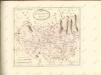

Stato del Piemonte
1 : 260000 Mollova mapová sbírka
Karte der Thäler von Bagne, Nendaz u. Hérémence im Wallis
1 : 300000 1 Karte G. St. Topogr. Anstalt v. J. Wurster u. Comp., [Winterthur]
Topographische Karte der Schweiz
1 : 100000 25 Karten vermessen und hrsg. auf Befehl der Eidgenössischen Behörden ; aufgenommen unter der Aufsicht des Generals G.H. Dufour Eidg. Topographisches Bureau, [Genève], [später: Bern]
Valesiae Altera et VII. Nova Tabula. [Karte], in: Claud. Ptolemaeus. Geographia lat. cum mappis [...], S. 356.
1 Karte aus Atlas Münster, Sebastian [und Ptolemaeus, Claudius]
Aosta
1 : 200000 Herder, Bartholomew
Carte du païs de Vallais, ou Wallisser-land
1 Karte : Kupferdruck ; 35 x 44 cm Valck; Schenk; Duval apud G. Valk et P. Schenk