Maps of Sahara
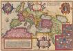
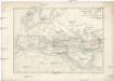
Romani Imperii Imago. [Karte], in: Theatrum orbis terrarum, S. 451.
1 Karte aus Atlas Ortelius, Abraham
Historische Weltkarte
Afrika severní Pařízek, Aleš Vincenc Niederhofer, Ondřej
Historische Weltkarte
Afrika severní Pařízek, Aleš Vincenc Niederhofer, Ondřej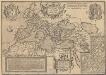
Romani Imperioo Imago. [Karte], in: Theatrum orbis terrarum, S. 450.
1 Karte aus Atlas Ortelius, Abraham Vrients, Jan Baptista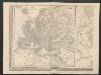
Europa
1 : 12000000 [Verlag nicht ermittelbar]
[Historisch-geographischer Atlas zu den allgemeinen Geschichtswerken von C. v. Rotteck, Pölitz u. Becker] : Übersichtskarte für die Geschichte der ältesten Zeit bis auf Cyrus
von Julius Loewenberg Lithographie von B. Herder in Freiburg im Breisgau [Freiburg im Breisgau] : [Herder]
Geologie von Europa nach den Hauptverhältnissen
Erster Band, enthaltend in vier Abtheilungen die Erscheinungen der anorganischen Natur: 1. Meteorologie und Klimatographie. 2. Hydrologie und Hydrographie. 3. Geologie. 4. Tellurischer Magnetismus Humboldt, Alexander von Verlag von Justus Perthes
Europa zur Zeit Karls des Grossen
Europa Karl I., Heiliges Römisches Reich, Kaiser
Übersichts Karte zu den Reisen in Europa, Asien und Afrika unternommen von dem k. k. oesterreich. Bergrathe Joseph Russegger in den Jahren von 1835 bis 1841
1 : 11400000 Afrika E. Schweizerbart'schen Buchhandlung
Übersichts Karte zu den Reisen in Europa, Asien und Afrika unternommen von dem k. k. oesterreich. Bergrathe Joseph Russegger in den Jahren von 1835 bis 1841
1 : 11400000 Afrika
Übersichts Karte zu den Reisen in Europa, Asien und Afrika
1 : 11700000 Afrika severovýchodní Verlag der E. Schweizerbrat'schen Buchhandlung
Carte mar.ne d'une partie de l'Europe, de l'Asie et de l'Afrique
1 Karte : Kupferdruck ; 41 x 49 cm Königliche Akademie der Wissenschaften
Übersichts-Karte der alten Welt zur Zeit Alexanders d. Gr
Afrika severní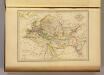
Geographie du Moyen Age.
1 : 35000000 Malte-Brun, Conrad, 1775-1826
Mohammedanischen Staaten-Systems.
1 : 25000000 Flemming, Carl

Orbis terrarum notus usque ad Alexandri Magni tempora
Asie jihozápadní Spruner, Karl von Behrens, W. Justus Perthes
Universal-Historie auf der Land-Karten
Afrika severní Ehmann, Andreas
Empire de la Porte ottomane en Europe, en Asie et en Afrique avec les pays qui lui sont tributaires
1 : 9000000 Lotter Family (Augsburg, Germany) Frères Lotter
[General Karte des Osmanischen Reiches]
Grosser Hand-Atlas über alle Theile der Erde in 170 Karten Meyer, J. Verlag des Bibliographischen Instituts
Map of the World According to Strabo.
1 : 32500000 Playfair, Principal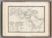
Monde Connu des Hebreux.
Levasseur, E.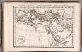
Carte de Premiers Ages de Monde ... 1825.
1 : 17500000 Delamarche, Felix
[Übersicht der Verbreitung der wichtigsten Kultur-, Baum- und Strauchgewächse in Europa]
Zweiter Band, enthaltend in vier Abtheilungen die Vertheilung der Organismen: 5. Pflanzen-Geographie, 6. Thier-Geographie, 7. Anthropographie, 8. Ethnographie Humboldt, Alexander von Verlag von Justus Perthes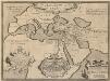
Geographia Sacra. [Karte] [Welt] [Nebenkarte], in: Theatrum orbis terrarum, S. 432.
1 Karte aus Atlas Ortelius, Abraham Vrients, Jan Baptista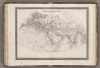
Monde Connu des Anciens.
1 : 34000000 Monin, C.V.
The Turkish Empire in Europe, Asia and Africa, divided into all its governments, together with the other territories that are tributary to it, as also the dominions of ye Emperor of Marocco.
from The world described, or, A new and correct sett of maps : shewing the kingdoms and states in all the known parts of the earth, with the principal cities, and most considerable towns in the world ... / ... by Herman Moll, geographer ...
Starý svět až po časy Daria
Asie západní kamenopisní [sic] ústav Jos. Jelínka
![Romani Imperii Imago. [Karte], in: Theatrum orbis terrarum, S. 451.](https://images-2.georeferencer.com/images/iiif/612545302560/full/,300/0/native.jpg)

