Maps of Mediterranean Sea
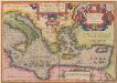
Aeneae Troiani Navigatio Ad Virgilii Sex priores Aeneidos. [Karte], in: Theatrum orbis terrarum, S. 448.
1 Karte aus Atlas Ortelius, Abraham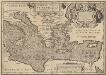
Aeneae Troiani Navigatio Ad Virgilii Sex priores Aeneidos. [Karte], in: Theatrum orbis terrarum, S. 532.
1 Karte aus Atlas Ortelius, Abraham Vrients, Jan Baptista
Orientalior districtus Maris Mediterranei
1 Karte : Kupferdruck ; 47 x 58 cm Renard apud L. Renard
[134][137] Orientalior districtus Maris Mediterranei ..., uit: Atlas sive Descriptio terrarum orbis
Annotatie: Gedigitaliseerde versie. Amsterdam. Heiloo : Picturae (vervaardiger), 2015. tiff-bestand. Gedigitaliseerd: 07-01-2015; Origineel: Universiteitsbibliotheek Vrije Universiteit (XL.05127.-) ; Netherlands; Titelpagina ontbreekt Wit, Frederik de Amsterdam : Frederick de Wit
De landen van 't Romeinsche gebied in welke de Christen kerk, kort na Christus hemelvaard, door den dienst der apostelen is uitgebreid : tot verklaringe van de Handelingen der Apostelen
1 : 6500000 afgebeeld door W.A. Bachiene J. van Jagen mapp. sculpsit, et figur. apposit sculpturam curavit ; S. Fokke fecit. Uitgegeven te Gorinchem : by Nicolaas Goetzee
Imperii Tvrcici Evropaei terra, in primis Graecia cum confiniis
1 : 4530000 Turecko Harenberg, Johann Christoph curantibus Homannianis Heredibus
Karte der griechischen Welt
Evropa jižní F. Tempsky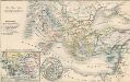
Die Zeit der Kreuzzüge
Südeuropa, Mittelmeerraum, Kreuzzüge
IMPERII TVRCICI EVROPAEI TERRA, in primis GRAECIA
1 : 4700000 Turecko Harenberg, Johann Christoph curantibus Homannianis Heredibus
Imperii Tvrcici Evropaei terra, in primis Graecia cum confiniis, ad intelligendos scriptores N.T. ceterosque graecos et latinos accom[m]odata
1 : 4530000 Turecko Harenberg, Johann Christoph curantibus Homannianis Heredibus
Imperii Turcici Europaei Terra, in primis Graecia cum confiniis
1 : 4400000 Mollova mapová sbírka Harenberg, Johann Christoph Homann, Johann Baptista - dědici
M. Herberers ongelukkige voyagie gedaan in verscheyde gedeeltens van Asia en Africa
1 : 24000000 1 Karte : Kupferdruck ; 22 x 29 cm Aa, Pieter van der [Michel Herberer]
Nova totius Graeciae, Italiae, Natoliae, Hungariae nec non Danubii fluminis cum adiacentib[us] regnis et provinc. tabula
1 : 7700000 Anatolie (Turecko) Sandrart, Johann Jakob von J. Sandrart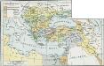
Osmanisches Reich bis 1683
1 : 18000000 Osmanisches Reich Expansion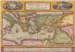
Peregrinationis Divi Pauli Typus Corographicus [...] [Karte], in: Theatrum orbis terrarum, S. 442.
1 Karte aus Atlas Ortelius, Abraham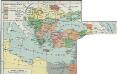
I. Osmanisches Reich bis 1683
1 : 28000000 Osmanisches Reich Expansion
Geschäftsverbindungen und Kupferhandel der Medici 1393-1395
Europa Medici, Bankiers, Fuersten, Italien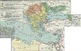
II. Rückgang des Osmanischen Reichs (Orientalische Frage) seit 1683
1 : 28000000 Osmanisches Reich
Imperii Tvrcici Evropaei Terra, in primis Graecia cum confiniis
1 : 4400000 Mollova mapová sbírka Harenberg, Johann Christoph Homann, Johann Baptista - dědici
Süd-Europa & Vorder-Asien zur Zeit der Kreuzzüge
Südosteuropa, Byzantinisches Reich, Kreuzzüge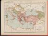
L'Empire Grec à la mort de Basile le Bulgarochtone et sous ses Héritiers
Byzantinisches Reich Basileios II.
Itinera expeditionum sacrarum
Europa, Mittelmeerraum, Reiseweg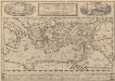
Peregrinationis Divi Pauli Typus Corographicus. [...] [Karte], in: Theatrum orbis terrarum, S. 441.
1 Karte aus Atlas Ortelius, Abraham Vrients, Jan Baptista
Karte des Mittelländischen Meeres
Středozemní moře-oblast Handtke, Friedrich C. Flemming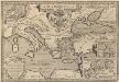
Argonautica. [Karte] [Europa.], [Thessalia und Umgebung], [Hellespontus, Phryxeum aequor, et Athamantidis fluenta.] [3 Nebenkarten], in: Theatrum orbis terrarum, S. 538.
1 Karte aus Atlas Ortelius, Abraham Vrients, Jan Baptista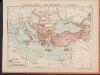
L'Empire Grec au Commencement du IX.e siècle
Byzantinisches Reich Kümmerly & Frey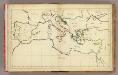
(Mediterranean Region)
1 : 10900000 Bowen, Frances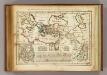
Regions, lieux dans le Nouveau Testament.
1 : 18000000 Delamarche, Charles Francois
Orbis Romani pars orientalis, auspiciis serenissimi principis Ludovici Philippi Aurelianorum ducis publici juris facta
1 : 4300000
![Aeneae Troiani Navigatio Ad Virgilii Sex priores Aeneidos. [Karte], in: Theatrum orbis terrarum, S. 448.](https://images-2.georeferencer.com/images/iiif/171048759783/full/,300/0/native.jpg)

