Maps of Marmara Region

Thraciae Veteris Typus. [Karte], in: Theatrum orbis terrarum, S. 407.
1 Karte aus Atlas Ortelius, Abraham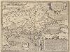
Thraciae Veteris Typus. [Karte], in: Theatrum orbis terrarum, S. 511.
1 Karte aus Atlas Ortelius, Abraham Vrients, Jan Baptista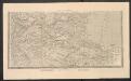
Carte Générale de la Valachie, de la Bulgarie et de la Roumilie
Nouvel atlas physique politique et historique de l'Empire ottoman et des états limitrophes en Europe, en Asie et en Afrique, en quarante feuilles Hellert, J.J. Bellizard, Dufour et Cie
La chaîne centrale d'après Ptolémée
Balkanhalbinsel Südosteuropa Geografie Ptolemaeus, Claudius
[Europäische Türkey in IV Blättern]
Grosser Hand-Atlas über alle Theile der Erde in 170 Karten Meyer, J. Verlag des Bibliographischen Instituts
(Europaischen Turkei) 4.
1 : 1580000 Berghaus, Heinrich; Flemming, Carl; Handtke, Friedrich H.; Sohr, Karl
Europ. Turkey IV.
1 : 1740000 Grassl, J. (Joseph)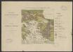
Carte géologique de la mer Egée par Mr L. de Launay : et des régions avoisinantes au 1/3 500 000e
1 : 3500000 Launay, L. de Paris :
Thrakien in der Zeit der Osmanen
Thrakien, Osmanisches Reich, Verwaltungsgliederung Zwick, J.

Macedonia et Thracia.
1 : 5700000 Fenner, Rest.
Graecaei pars septentrionalis
1 : 1300000 Řecko
Bojiště turecko-ruské na Podunají
Balkánský poloostrov
Bojiště turecko-ruské na Podunají
Balkánský poloostrov
Thracia Vetus
1 : 1100000 Mollova mapová sbírka Covens, Johannes Covens, Johannes I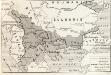
Modifications territoriales dans le Balkans: Traité de Bukarest
Balkanhalbinsel Bukarest / Friede <1913>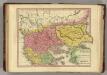
Graecia Pars Septentrionalis aliter Macedonia, Thessalia & Epirus cum Tracia. (1826)
1 : 2900000 Tanner, Henry S.
Modifications territoriales dans le Balkans: Conférence de Londres ; Traité de Bukarest
Balkanhalbinsel Bukarest / Friede <1913> Staatsgrenze Londoner Vertrag Th. Weinreb del.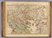
Graeciae pars Septentrionalis.
1 : 1280000 L'Isle, Guillaume de, 1675-1726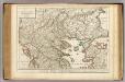
Graeciae pars Septentrionalis.
1 : 1280000 L'Isle, Guillaume de, 1675-1726
81. Bulgaria.
1 : 1500000 Touring club italiano
Bulgaria et Romania divisa in singulares sangiacatus Silistriam, Nicpolin, Bodinum, Sardiam, Bysantium, Kirkeliam et Gallipolin, una cum finitimus regionibus Valachia, Servia, etc
1 : 1340000 Bulharsko Valk, Gerhard Valk, Leon. G. et L. Valk
[Balkan]
1 : 3000000 Bulgarien, Balkanhalbinsel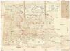
Bulgarie
1 : 1000000 Bulharsko Service Géographique de l'Armée Britannique
Graeciae pars septentrionalis
1 : 1280000 Řecko Lotter, Tobias Conrad Tobias Conrad Lotter
[Marmarameer]
Türkei Marmarameer Seeschlacht
Boundary of demilitarized zone about Constantinople
1 : 1000000 Meeting of Alllied Naval and Military Advisers, London 16.2.20. Demilitarized zones in north-west Turkey. Illustrates post-war settlement. War Office
Demilitarized zones in north-west Turkey
1 : 1000000 Demilitarized zones in north-west Turkey. Illustrates post-war settlement. War Office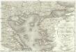
Carte de la Turquie d'Europe
1 : 1300000 Egejské moře-oblast Konrad, Al. Palma, Gaetano
![Thraciae Veteris Typus. [Karte], in: Theatrum orbis terrarum, S. 407.](https://images-2.georeferencer.com/images/iiif/016628275912/full/,300/0/native.jpg)

