Maps of Ocaña
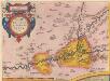
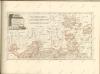
Carpetaniae Partis Descr. 1584. [Karte], in: Theatrum orbis terrarum, S. 60.
1 Karte aus Atlas Ortelius, Abraham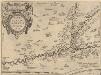
Carpetaniae Partis Descr. 1584. [Karte], in: Theatrum orbis terrarum, S. 107.
1 Karte aus Atlas Ortelius, Abraham Vrients, Jan Baptista
Toledo e dintorni: lavori difensivi eseguiti dal nemico [C.T.V. Corpo Truppe Volontarie. Comando Artiglieria (Itàlia)]
1 : 25000 1 Mapa imprès amb anotacions manuscrites. Carpeta: Guerra Civil. Datació aproximada. [C.T.V. Corpo Truppe Volontarie. Comando Artiglieria (Itàlia)]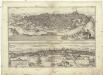
Toletum
Toledo (Španělsko) Braun, Georg Hogenberg, Franz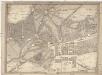
Topografia del real sitio de Aranjuez
Aranjuez (Španělsko) Aguirre, Domingo de
Mapa de la provincia de Madrid
1 Karte : Kupferdruck ; 33 x 37 cm López s.n.
Mapa de la provincia de Madrid comprehende el partido de Madrid, y el de Almonacid de Zorita
1 : 250000 compuesto por D. Tomàs Lopez de Vargas Machuca, geografo de los Dominios de S. M [...] Madrid : [Thomas Lopez]
Madrid
1 : 200000 Coello, Francisco [Verlag nicht ermittelbar]
Segoviæ et Avilæ provinciarum charta geographica
1 Karte : Kupferdruck ; 43 x 55 cm López; Güssefeld; Vogel in lucem edita per Hom. Hered
Mapa de la provincia de Toledo
1 Karte : Kupferdruck ; 37 x 40 cm López s.n.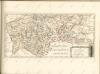
Madrid
1 : 200000 1 Mapa imprès. Carpeta: Guerra Civil. Datació aproximada. C.T.V. Corpo Truppe Volontarie. Sezione Topocartografica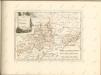

Mapa de las cercanias de Madrid
1 Karte : Kupferdruck ; 36 x 37 cm López s.n.
Madrid / formado y publicado por el Instituto Geográfico y Estadístico, bajo la direccion del excmo. señor Don Cárlos Ibañez é Ibañez de Ibero ; P. Peñas grabó
1 : 50000 Cárlos Ibañez é Ibañez de Ibero 1825-1891; P. Peñas; Instituto Geográfico y Estadístico [S.l. : Instituto Geográfico y Estadístico]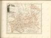

Castiliae novae pars orientalis
1 : 540000 Kastilie (Španělsko) Güssefeld, Franz L. López, Tomás apud Hommanianos Heredes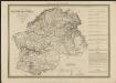
Cataluña con las nuevas divisiones
1 : 600000 formada por A. H. Dufour Paris : Bulla
[Carte d'Espagne et de Portugal en neuf feuilles, 5]
1 Blatt : 31 x 41 cm P.G. Chanlaire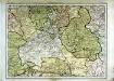
Espagne et Portugal, 5
1 Blatt : 31 x 42 cm Mentelle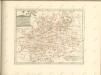

Castiliæ novæ pars occidentalis provincias Madrit, Toledo et Mancha comprehendens
1 Karte : Kupferdruck ; 48 x 46 cm Güssefeld; López apud Homannianos Heredes
Castiliæ novæ pars orientalis provincias Cuenca et Guadalaxara comprehendens
1 Karte : Kupferdruck ; 51 x 43 cm Güssefeld; López apud Homannianos Heredes
A map of old & new Castile
1 : 1100000 Kastilie (Španělsko) Mendes Silva, Rodrigo Ioh. Senex
Castilla la Nueva con las nuevas divisiones
1 Mapa. Atlas Nacional de España Dufour, A.H. 0
Neueste Generalkarte von Portugal und Spanien, 2
1 Blatt : 71 x 50 cm Schrämbl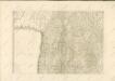


![Carpetaniae Partis Descr. 1584. [Karte], in: Theatrum orbis terrarum, S. 60.](https://images-2.georeferencer.com/images/iiif/542484369881/full/,300/0/native.jpg)

