Maps of Ireland
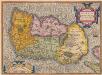
Hiberniae, Britannicae Insulae, Nova Descriptio. Irlandt. [Karte], in: Theatrum orbis terrarum, S. 42.
1 Karte aus Atlas Ortelius, Abraham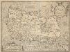
Hiberniae, Britannicae Insulae, Nova Descriptio. Irlandt. [Karte], in: Theatrum orbis terrarum, S. 89.
1 Karte aus Atlas Ortelius, Abraham Vrients, Jan Baptista
The Kingdom of Ireland devided into fewer provinces...
From Ireland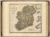
Ireland.
1 : 1150000 Cary, John, ca. 1754-1835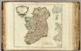
Royaume d'Irlande.
1 : 1080000 Robert de Vaugondy, Gilles, 1688-1766
Ireland
Hand-Atlas über alle Theile der Erde nach dem neuesten Zustande und über das Weltgebäude Stieler, Adolf bei Justus Perthes
Ireland
Hand-Atlas über alle Theile der Erde nach dem neuesten Zustande und über das Weltgebäude Stieler, Adolf bei Justus Perthes
Ireland.
1 : 2750000 Seaman, James V.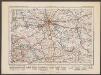
Irlandiae regnum [Karte], in: Gerardi Mercatoris Atlas, sive, Cosmographicae meditationes de fabrica mundi et fabricati figura, S. 85.
1 Karte aus Atlas Mercator, Gerhard Montanus, Petrus

Das Konigreich Ireland
1 Karte : Kupferdruck ; 26 x 20 cm Reilly F. J. J. von Reilly
Karte von Ireland
1 Karte : Kupferdruck ; 62 x 55 cm Kitchin; Schrämbl; Stenger zu finden in eigenem Verlage Schrämbl
Le royaume d'Irlande
1 Karte : Kupferdruck ; 56 x 47 cm Le Rouge; Basset chez Basset rue St. Jacques
Le royaume d'Irlande
1 Karte : Kupferdruck ; 56 x 47 cm Le Rouge; Basset; Basset chez Basset rue St. Jacques
Regnum Hiberniæ
1 Karte : Kupferdruck ; 56 x 48 cm Lotter Tobias Konrad Lotter
L'Irlande
1 Karte : Kupferdruck ; 85 x 52 cm s.n.
A new and accurate map of Ireland
1 Karte : Kupferdruck ; 31 x 21 cm Bowen s.n.
Le royaume d'Irlande
1 Karte : Kupferdruck ; 56 x 47 cm Le Rouge par et chez le Sr. Le Rouge ing.r géographe du roy ruë des Augustins
Regnum Hiberniæ
1 Karte : Kupferdruck ; 56 x 48 cm Seutter Matthäus Seutter
Hyberniæ regni in provincias Ultoniam, Connachiam, Lageniam, Momoniamq divisi tabula accuratissima
1 Karte : Kupferdruck ; 57 x 49 cm by I. Cóvens en C. Mortier op de Vygendam
Regni Hiberniæ accurata tabula
1 Karte : Kupferdruck ; 38 x 32 cm Weigel; Moll; Kauffer Christoph Weigel
Hiberniæ regnum
1 Karte : Kupferdruck ; 55 x 47 cm Homann; Petty; Visscher Johann Baptist Homann
Hiberniæ regnum
1 Karte : Kupferdruck ; 55 x 46 cm Visscher Nicolaes Visscher

Ireland.
1 : 1650000 Mitchell, Samuel Augustus
Ireland.
1 : 1650000 Mitchell, Samuel Augustus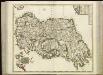
[88][88] Regnum Hiberniae ..., uit: Atlas sive Descriptio terrarum orbis
Annotatie: Gedigitaliseerde versie. Amsterdam. Heiloo : Picturae (vervaardiger), 2015. tiff-bestand. Gedigitaliseerd: 07-01-2015; Origineel: Universiteitsbibliotheek Vrije Universiteit (XL.05127.-) ; Netherlands; Titelpagina ontbreekt Wit, Frederik de Amsterdam : Frederick de Wit

Jreland
Stieler's Hand-Atlas Stieler, Adolf bei Justus Perthes
![Hiberniae, Britannicae Insulae, Nova Descriptio. Irlandt. [Karte], in: Theatrum orbis terrarum, S. 42.](https://images-2.georeferencer.com/images/iiif/893505113219/full/,300/0/native.jpg)

