Maps of Ireland

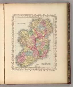
Ireland.
1 : 1650000 Mitchell, Samuel Augustus
Ireland.
1 : 1650000 Mitchell, Samuel Augustus
Ireland.
1 : 1650000 Tanner, Henry S.

Ireland.
1 : 2750000 Seaman, James V.
Ireland
1 : 1500000 Andree, Richard
49-50. Irlandia, Scozia.
1 : 1500000 Touring club italiano
Ireland.
1 : 1500000 Andree, Richard; Times (London, England)
Ireland.
1 : 1013760 Letts, Son & Co.
Ireland ... Scotland.
1 : 1584000 Johnson, A.J.
Ireland.
1 : 1900800 Tallis, J. & F.
Ireland.
1 : 1200000 Society for the Diffusion of Useful Knowledge (Great Britain)
Ireland.
1 : 3500000 Fenner, Rest.
Ireland.
1 : 1900000 Carey, Mathew
Ireland.
1 : 1774080 Lucas, Fielding Jr.
Ireland.
1 : 2000000 Carey, Mathew
Charte von Ireland
1 Karte : Kupferdruck ; 56 x 46 cm Kitchin; Beaufort; Jefferys im Verlage des Geographischen Instituts
Ireland (outline)
1 : 2000000 Patteson, Edward
Ireland.
1 : 2000000 Patteson, Edward
Charte von Ireland
1 Karte : Kupferdruck ; 57 x 47 cm Stieler; Beaufort in der kaiserl: privil: Kunsthandlung Adam Gottlieb Schneider und Weigels
Carte du royaume d'Irlande
1 Karte : Kupferdruck ; 72 x 50 cm Hérisson; Basset; Basset chez Basset rue St. Jacques no. 670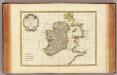
Irlande.
1 : 2400000 Bonne, Rigobert, 1727-1794
Carte ancienne et moderne de l'Irlande
1 Karte : Kupferdruck ; 33 x 28 cm Châtelain s.n.
Nouvelle carte de l'Irlande
1 Karte : Kupferdruck ; 33 x 27 cm Châtelain s.n.
Carte du gouvernement civil et militaire avec l'etat des officiers du royaume d'Irlande
2 Karten auf 1 Blatt : Kupferdruck ; je 14 x 11 cm, Bildgrösse 36 x 46 cm Châtelain s.n.
Regnum Hiberniæ
1 Karte : Kupferdruck ; 55 x 48 cm Valck; Valck Gerard und Leonardus Valck
Le royaume d'Irlande
1 Karte auf 2 Blatt : Kupferdruck ; 87 x 60 cm Jaillot; Sanson chez H. Iaillot
Le royavme d'Irlande
1 Karte : Kupferdruck ; 59 x 45 cm Coronelli; Petty; Nolin chez I. B. Nolin sur le quay de l'Horloge du Palais proche la rüe de Harlay a l'enseigne de la place des Victoires
Novissima ac præ cæteris alus accuratissima regni et insulæ Hiberniæ delineatio
1 Karte : Kupferdruck ; 70 x 48 cm Wit F. de Wit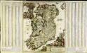
Hyberniæ regni in provincias Ultoniam, Connachiam, Lageniam, Momoniamq divisi tabula accuratissima
1 Karte auf 3 Blatt : Kupferdruck ; 57 x 49 cm, Bildgrösse 61 x 102 cm Allard by Carolus Allard op den Dam
Regnum Hiberniæ
1 Karte : Kupferdruck ; 57 x 48 cm Wit apud Fredericum de Wit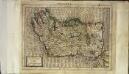
Irlandiæ regnum
1 Karte : Kupferdruck ; 17 x 24 cm Mercator Cloppenburgh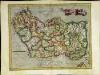
Irlandiæ regnum
1 Karte : Kupferdruck ; 31 x 40 cm Mercator; Hondius Henricus Hondius
Irlandiæ regnum
1 Karte : Kupferdruck ; 31 x 40 cm Mercator; Hondius Jodocus Hondius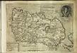
Hiberniae britan[n]icae insvlae nova descriptio
1 Karte : Kupferdruck ; 22 x 30 cm Quad; Bussemacher Johannes Bussemacher
Eryn
1 Karte : Kupferdruck ; 34 x 47 cm Ortelius s.n.