Maps of Ukraine
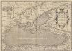
Pontus Euxinus. Aequor Iasonio pulsatum remige primum. [Karte], in: Theatrum orbis terrarum, S. 508.
1 Karte aus Atlas Ortelius, Abraham Vrients, Jan Baptista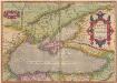
Pontus Euxinus. Aequor Iasonis pulsarum, remige primum. [Karte], in: Theatrum orbis terrarum, S. 413.
1 Karte aus Atlas Ortelius, Abraham
Nouvelle carte de la petite Tartarie ou Taurie, montrant les frontieres de l'Imperatrice de Russie, et l'Empereur des Turcs, tant en Europe qu'en Asie
1 : 2750000 composée sur les observations les plus nouvelles A Amsterdam : chez Elwe & Langeveld
Schwarze Meer, Kustenlander.
1 : 4150000 Radefeld, Carl Christian Franz, 1788-1874
Nova mappa Maris Nigri et Freti Constantinopolitani quam exactissime consignata et in lucem edita per Matth. Seutter
Schwarzmeer-Gebiet, Bosporus Seutter, Matthäus
The Black Sea and surronding countries”
1 mapa. Datat entre 1840 i 1849. Hughes, William
Composite: Theatre de la guerre, Petite Tartarie, Crimee, Mer Noire.
1 : 1250000 L'Isle, Guillaume de, 1675-1726
Karte der Grenzprovinzen der Türkey, Russlands &sterreichs, des Schwaryen Meeres etc
Rakousko d. Englischen Kunstanstalt v. A.H.Payne
Neueste Karte der Küstenländer des Schwarzen Meeres
1 : 4180000 Černé moře-oblast Radefeld, Carl Christian Franz Verlag des Bibliographischen Instituts
Neueste Karte der Küstenländer des Schwarzen Meeres
1 : 4180000 Černé moře-oblast Radefeld aus der Geograph. Graviranstalt des Bibliograph. Instituts
Nova et accurata Tartariae europaeae seu minoris et in specie Crimeae delineatio geographica / manu
1 : 2900000 1 Karte : Kupferdruck ; 48 x 56 cm [Matthäus Seutter]
Neueste Karte der Küstenländer des Schwarzen Meeres
Grosser Hand-Atlas über alle Theile der Erde in 170 Karten Meyer, J. Verlag des Bibliographischen Instituts
Pontos Euxeinos / ex conitabus geographicis Abrahami Ortelij
1 : 3750000 1 Karte : Kupferdruck ; 35 x 50 cm Ortelius, Abraham [Officina Plantiniana]

Nova et accurata Tartariae Europaeae seu minoris et in specie Crimae delineatio geographica
1 : 3000000 Krym (Ukrajina) Seutter, Matthäus Probst, Johann Michael Ioh. Michael Probst
Nova et accurata Tartariae Europae seu minoris et in specie Crimae delineatio geographica
1 : 3000000 Černé moře-oblast Seutter, Matthäus Probst, Johann Michael Ioh. Michael Probst
Nova et accurata Tartariae Europae seu minoris et in specie Crimae delineatio geographica
1 : 3000000 Krym (Ukrajina) Seutter, Matthäus Probst, Johann Michael bey Ioh. Michael Probst
Nova et accurata Tartariae Europaeae seu minoris et in specie Crimeae delineatio geographica
1 : 2900000 Krym (Ukrajina) Seutter, Matthäus sumtibus Matthaei Seuterri
Nova et accurata Tartariae Europaeae seu minoris et in specie Crimeae delineatio geographica
1 : 2900000 Krym (Ukrajina) Seutter, Matthäus sumtibus Matthaei Seuterri
Nova et accurata Tartariae Europaeae seu minoris et in specie Crimeae delineatio geographica
Černé moře-oblast Seutter, Matthäus Netopil, Fr. sumtibus Matthaei Seuterri

Nova mappa maris nigri et freti Constantinopolitani
1 Karte : Kupferdruck ; 47 x 56 cm Lotter Tobias Konrad Lotter
Nova mappa Maris Nigri et freti Constantinopolitani
1 : 2200000 Černé moře-oblast Lotter, Tobias Conrad Tob. Conr. Lotter
Carte des environs de la Mer-Noire où se trouvent l'Ukrayne, la Petite Tartarie, la Circassie, la G
1 : 2500000 1 Karte auf 2 Blatt : Kupferdruck ; 50 x 92 cm Robert de Vaugondy, Didier chez Delamarche rue du Foin près celle de la Harpe au collége de M.e Gervais
Tabula Geographica QUA PARS RUSSIAE MAGNAE, PONTUS EUXINUS seu MARE NIGRUM et TARTARIA MINOR
1 : 3000000 Anatolie (Turecko) Homann, Johann Baptist a Ioh. Baptista Homanno
Tabula geographica qua pars Russiae Magnae, Pontus Euxinus seu Mare Nigrum et Tauriae Regnum cum finitimis Bulgariae, Romaniae et Natoliae provincis exhibetur
1 : 3000000 Anatolie (Turecko) Homann, Johann Baptist a Ioh. Baptista Homanno
Das Deutschtum II. 2.
Schwarzmeer-Gebiet Ethnische Gruppe, Deutsche
Pontus Euxinus et quae adjacent
1 : 4440000 Bospor (Turecko : průliv) Spruner, Karl von Justus Perthes
![Pontus Euxinus. Aequor Iasonio pulsatum remige primum. [Karte], in: Theatrum orbis terrarum, S. 508.](https://images-2.georeferencer.com/images/iiif/355416522756/full/,300/0/native.jpg)

