Maps of Ukraine

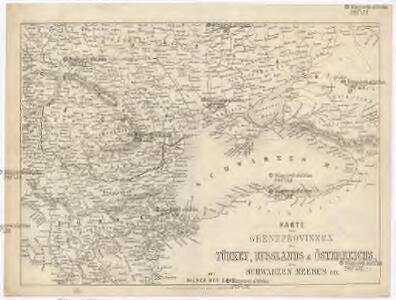
Karte der Grenzprovinzen der Türkey, Russlands &sterreichs, des Schwaryen Meeres etc
Rakousko d. Englischen Kunstanstalt v. A.H.Payne
Eur. Russland
Rusko jižní
Carte de la Mer Noire comprenant la plus grande partie de l'Empire Otoman, partie des etats de l'Emperieur, de la Russie, & ca
1 : 2400000 Balkánský poloostrov Dezauche, Jean-André Dezauche
The Black Sea and surronding countries”
1 mapa. Datat entre 1840 i 1849. Hughes, William
Nova et accurata Tartariae europaeae seu minoris et in specie Crimeae delineatio geographica / manu
1 : 2900000 1 Karte : Kupferdruck ; 48 x 56 cm [Matthäus Seutter]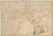
To His Excellency the count of Czernichew commander in chief of her Majesty the empress of all the Russias fleet and Gallies lieutenant general of her armies, one of the lords of her admiralty, ambassador extraordinary and plenipotentiary to his Majesty the king of Great Britain, a knight of the Order of the White Eeagle, and St. Ann, &c. &c. &c, this map of the present seat of war, between the Russians, Poles, and Turks
1 : 1650000 Ukrajina jižní Dury, Andrew Caldwal, J. Andrew Dury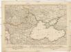
Kriegs Theater zwischen Russland und der Ottomanischen Pforte
Balkánský poloostrov Mollo, Tranquillo T. Mollo
Karta teatra vojny v Turcii v 1828 i 1829 godach
Balkánský poloostrov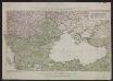
Kriegstheater Oder Graenzkarte Oesterreichs, Russlands, Und Der Türkey enthaltend Das Koenigreich Ungarn, Siebenbürgen, Moldau, Bessarabien, Walachey, Bulgarien, Servien, Bosnien, Sclawonien, Croatien, Albanien, Romanien, Macedonien, einen Theil Griechenlands, und des Archipelagus, die Dardanellen, das schwarze und asowische Meer, die Krim, Tatarey, Kuban, Circassien & & Nebt einem Theil von Russland, Polen, Schlesien, Maehren, Oesterreich, Steuermark &. ; C. Priv. S. C. M.
Schwarzmeer-Gebiet, Südosteuropa, Krieg Schütz, Carl ; Müller, Franz ;
Nouvelle carte de la petite Tartarie ou Taurie, montrant les frontieres de l'Imperatrice de Russie, et l'Empereur des Turcs, tant en Europe qu'en Asie
1 : 2750000 composée sur les observations les plus nouvelles A Amsterdam : chez Elwe & Langeveld
Nova et accurata Tartariae Europaeae seu minoris et in specie Crimae delineatio geographica
1 : 3000000 Krym (Ukrajina) Seutter, Matthäus Probst, Johann Michael Ioh. Michael Probst
Nova et accurata Tartariae Europae seu minoris et in specie Crimae delineatio geographica
1 : 3000000 Černé moře-oblast Seutter, Matthäus Probst, Johann Michael Ioh. Michael Probst
Nova et accurata Tartariae Europae seu minoris et in specie Crimae delineatio geographica
1 : 3000000 Krym (Ukrajina) Seutter, Matthäus Probst, Johann Michael bey Ioh. Michael Probst
Nova et accurata Tartariae Europaeae seu minoris et in specie Crimeae delineatio geographica
1 : 2900000 Krym (Ukrajina) Seutter, Matthäus sumtibus Matthaei Seuterri
Nova et accurata Tartariae Europaeae seu minoris et in specie Crimeae delineatio geographica
1 : 2900000 Krym (Ukrajina) Seutter, Matthäus sumtibus Matthaei Seuterri
Nova et accurata Tartariae Europaeae seu minoris et in specie Crimeae delineatio geographica
Černé moře-oblast Seutter, Matthäus Netopil, Fr. sumtibus Matthaei Seuterri
Russisch-türkischer Kriegsschauplatz, 1877
1 : 3700000 Petermann, August Perthes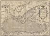
Pontus Euxinus. Aequor Iasonio pulsatum remige primum. [Karte], in: Theatrum orbis terrarum, S. 508.
1 Karte aus Atlas Ortelius, Abraham Vrients, Jan Baptista
(Europaischen Russland III).
1 : 5000000 Berghaus, Heinrich; Flemming, Carl; Handtke, Friedrich H.; Sohr, Karl
Schwarze Meer, Kustenlander.
1 : 4150000 Radefeld, Carl Christian Franz, 1788-1874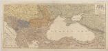
[Kaart], uit: Oorlogskaart van Turkije, Zuid-Rusland en grenslanden
1 : 2250000 Annotatie geografische gegevens: Legenda Amsterdam : Seyffardt's Boekhandel
Ukrania seu Cosacorum Regio Walachia item Moldavia et Tartaria minor / exc. Christ. Weigelio ; M. Ka
1 : 4600000 1 Karte : Kupferdruck ; 33 x 39 cm Kauffer, Michael Weigel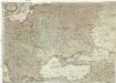
Theatre de la guerre actuelle, comprenant la Prusse, la Pologne, une grande partie de la Russie & de la Turque Européenne et Asiatique jusqu'á la mer Caspienne
1 : 3330000 Kaspické moře-oblast Bonne, Rigobert Treuttel & Witz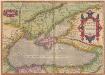
Pontus Euxinus. Aequor Iasonis pulsarum, remige primum. [Karte], in: Theatrum orbis terrarum, S. 413.
1 Karte aus Atlas Ortelius, Abraham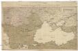
Kriegstheater oder Graenzkarte Oesterreichs, Russlands, und der Türkey
1 : 3000000 Balkánský poloostrov Schütz, C. Müller, Franz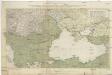
Kriegstheater oder Graenzkarte Oesterreichs, Russlands, und der Türkey
1 : 2950000 Evropa jihovýchodní Schütz, Carl Müller, Franz Artaria Compagnie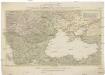
Kriegstheater oder Graenzkarte Oesterreichs, Russlands, und der Türkey
1 : 3000000 Balkánský poloostrov Schütz, C. Müller, Franz Artaria Compagnie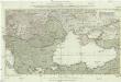
Kriegstheater oder Graenzkarte Oesterreichs, Russlands und der Türkey
1 : 3000000 Evropa jihovýchodní Schütz, C. Müller, Franz bey Artaria