Maps of Picardie
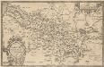
Picardiae, Belgicae regionis descriptio. [Karte], in: Theatrum orbis terrarum, S. 140.
1 Karte aus Atlas Ortelius, Abraham Vrients, Jan Baptista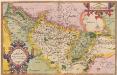
Picardiae, Belgicae regionis descriptio. [Karte], in: Theatrum orbis terrarum, S. 83.
1 Karte aus Atlas Ortelius, Abraham
Picardia Regio Belgica [Karte], in: Le théâtre du monde, ou, Nouvel atlas contenant les chartes et descriptions de tous les païs de la terre, Bd. 2, S. 29.
1 Karte aus Atlas Blaeu, Willem Janszoon und Blaeu, Joan Blaeu, Willem Janszoon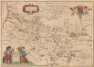
Picardia Regio Belgica [Karte], in: Novus Atlas, das ist, Weltbeschreibung, Bd. 2, S. 29.
1 Karte aus Atlas Blaeu, Joan Blaeu, Willem Janszoon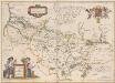
Picardia Regio Belgica [Karte], in: Theatrum orbis terrarum, sive, Atlas novus, Bd. 2, S. 32.
1 Karte aus Atlas Blaeu, Joan Blaeu, Willem Janszoon
Picardia [Karte], in: Gerardi Mercatoris et I. Hondii Newer Atlas, oder, Grosses Weltbuch, Bd. 2, S. 29.
1 Karte aus Atlas Mercator, Gerhard und Hondius, Jodocus Jansson, Jan
Picardia regio belgica
1 Karte : Kupferdruck ; 37 x 51 cm Blaeu; Blaeu; Surhon; Surhon apud Guiljelmum et Joannem Blaeu
Picardia
1 Karte : Kupferdruck ; 36 x 48 cm Mercator; Hondius Henricus Hondius
Picardia
1 Karte : Kupferdruck ; 36 x 49 cm Janssonius apud Ioannem Ianssonium
Picardiae, Belgicæ regionis descriptio
1 Karte : Kupferdruck ; 32 x 50 cm Ortelius; Surhon; Surhon s.n.
Picardia
1 : 361000 Pikardie (Francie)
Picardia
1 Karte : Kupferdruck ; 17 x 24 cm Mercator; Keere Cloppenburgh
Artesia comit
1 Karte : Kupferdruck ; 33 x 43 cm Mercator; Hondius Henricus Hondius
Artesia comit
1 Karte : Kupferdruck ; 33 x 43 cm Hondius; Mercator Jodocus Hondius
Artesia comit
1 Karte : Kupferdruck ; 33 x 43 cm Mercator s.n.
Carte du govvernement general de Picardie qui comprend la generalité d'Amiens avec l'Artois [et] les frontieres des Pays Bas
1 Karte : Kupferdruck ; 46 x 55 cm L'Isle les Heritiers de Homan
Artesia Comit: [Karte], in: Gerardi Mercatoris Atlas, sive, Cosmographicae meditationes de fabrica mundi et fabricati figura, S. 308.
1 Karte aus Atlas Mercator, Gerhard Montanus, Petrus
Picardia
1 Karte : Kupferdruck ; 14 x 19 cm Lambert Andreae
Partie meridionale de Picardie
1 Karte : Kupferdruck ; 47 x 61 cm L'Isle; Buache; Dezauche; Des Rosiers; Lesperon chez Dezauche successeur des S.rs Delisle et Buache rue des Noyers près celle des Anglois
Partie meridionale de Picardie
1 Karte : Kupferdruck ; 46 x 60 cm L'Isle chez J. Cóvens et C. Mortier geographes
Picardie meridionale.
1 : 210000 L'Isle, Guillaume de, 1675-1726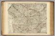
Picardie meridionale.
1 : 210000 L'Isle, Guillaume de, 1675-1726

Partie meridionale de Picardie
1 Karte : Kupferdruck ; 47 x 61 cm L'Isle; Rousseville; Des Rosiers; Lesperon chez l'auteur sur le quai de l'Horloge
Carte de la Picardie
1 Karte : Kupferdruck ; 50 x 64 cm Vauchelle; Agnes chez Agnes
North West Europe showing Allied progress on the front between Arras and Aisne
1 : 250000 First World War map of North West Europe. Map showing Allied progress on the front between Arras and Aisne. Allied line 1st July, 1916, 24th February and 28th March, 1917. War Office
Comté d'Artois Basse Picardie et Grande Partie dela Haute Picardie qui composent le Gouvernement General de Picardie avec le Cambresis partie des Comtez de Flandre et d'Haynaut Generalité d'Amiens
1 : 290000 Mollova mapová sbírka Nolin, Jean-Baptiste Nolin, Jean Baptiste II.
Sheet 8, uit: Stanford's large scale map of the seat of war / Stanford's Geographical Estab[lishmen]t
1 : 300000 Stanford's Geographical Establishment, Londen London : Stanford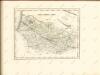
![Picardiae, Belgicae regionis descriptio. [Karte], in: Theatrum orbis terrarum, S. 140.](https://images-2.georeferencer.com/images/iiif/466307188955/full/,300/0/native.jpg)

