Maps of Picardy

Picardia [Karte], in: Gerardi Mercatoris et I. Hondii Newer Atlas, oder, Grosses Weltbuch, Bd. 2, S. 29.
1 Karte aus Atlas Mercator, Gerhard und Hondius, Jodocus Jansson, Jan
Picardiae, Belgicae regionis descriptio. [Karte], in: Theatrum orbis terrarum, S. 83.
1 Karte aus Atlas Ortelius, Abraham
Picardia Regio Belgica [Karte], in: Theatrum orbis terrarum, sive, Atlas novus, Bd. 2, S. 32.
1 Karte aus Atlas Blaeu, Joan Blaeu, Willem Janszoon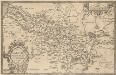
Picardiae, Belgicae regionis descriptio. [Karte], in: Theatrum orbis terrarum, S. 140.
1 Karte aus Atlas Ortelius, Abraham Vrients, Jan Baptista
Picardia Regio Belgica [Karte], in: Le théâtre du monde, ou, Nouvel atlas contenant les chartes et descriptions de tous les païs de la terre, Bd. 2, S. 29.
1 Karte aus Atlas Blaeu, Willem Janszoon und Blaeu, Joan Blaeu, Willem Janszoon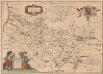
Picardia Regio Belgica [Karte], in: Novus Atlas, das ist, Weltbeschreibung, Bd. 2, S. 29.
1 Karte aus Atlas Blaeu, Joan Blaeu, Willem Janszoon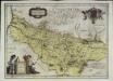
Picardia regio belgica
1 Karte : Kupferdruck ; 37 x 51 cm Blaeu; Blaeu; Surhon; Surhon apud Guiljelmum et Joannem Blaeu
Picardia
1 Karte : Kupferdruck ; 36 x 49 cm Janssonius apud Ioannem Ianssonium
Ile de France (Reims-Paris)
1 : 500000 Île-de-France (Francie) Velhagen & Klasing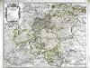
La generalité de Soissons
1 Karte : Kupferdruck ; 48 x 63 cm Jaillot; Denis; Aveline; Basset; Basset chez l'auteur joignant les grands Augustins, chés Basset rue St. Jacques au coin de celle des Mathurins à l'image S.e Genevieve
Picardia
1 : 361000 Pikardie (Francie)
Picardia
1 Karte : Kupferdruck ; 36 x 48 cm Mercator; Hondius Henricus Hondius
Le cours des rivieres d'Oyse, d'Aisne et de Marne, aux environs desquelles se trouve la généralité de Soissons
1 Karte : Kupferdruck ; 45 x 57 cm Desnos chez Desnos géographe et ingenieur pour les globes et spheres rue St. Jacques au globe
Artesia comit
1 Karte : Kupferdruck ; 33 x 43 cm Mercator; Hondius Henricus Hondius
Artesia comit
1 Karte : Kupferdruck ; 33 x 43 cm Hondius; Mercator Jodocus Hondius
Artesia comit
1 Karte : Kupferdruck ; 33 x 43 cm Mercator s.n.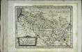
Picardia
1 Karte : Kupferdruck ; 17 x 24 cm Mercator; Keere Cloppenburgh
Sheet 8, uit: Stanford's large scale map of the seat of war / Stanford's Geographical Estab[lishmen]t
1 : 300000 Stanford's Geographical Establishment, Londen London : Stanford
Artesia Comit: [Karte], in: Gerardi Mercatoris Atlas, sive, Cosmographicae meditationes de fabrica mundi et fabricati figura, S. 308.
1 Karte aus Atlas Mercator, Gerhard Montanus, Petrus
Picardiae, Belgicæ regionis descriptio
1 Karte : Kupferdruck ; 32 x 50 cm Ortelius; Surhon; Surhon s.n.
Picardia
1 Karte : Kupferdruck ; 14 x 19 cm Lambert Andreae
Stoel des Oorlogs in Picardyen, Isle de France enz: Têatre de la Guerre en Picardie, Isle de France &c.
1 : 250000 Mollova mapová sbírka Allard, Abraham Allart, Abraham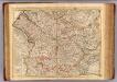
Picardie meridionale.
1 : 210000 L'Isle, Guillaume de, 1675-1726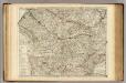
Picardie meridionale.
1 : 210000 L'Isle, Guillaume de, 1675-1726
[23], uit: Hydro-Oro und Chorographische General Karte des Koenigreichs der Niederlande und der angrenzenden Länder bis Paris : mit der Angabe der Kunst und Heer-Strassen und der Entfernung der Poststationen / ... zusammengetragen und reducirt von ... Wilhelm Müller
1 : 400000 titelvariant: Generalkarte des Koenigreichs Hannover; Annotatie: 1e supplement bij: Generalkarte des Koenigreichs Hannover (1818) Müller, Wilhelm (fl. 1818) [Hannover : Wilhelm Müller]
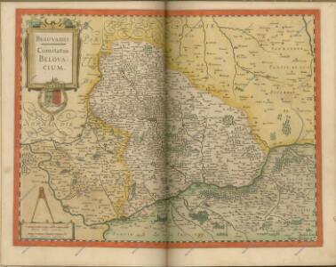
Beauvaisis Comitatus Belovacium. [Karte], in: Novus atlas absolutissimus, Bd. 4, S. 106.
1 Karte aus Atlas Janssonius Offizin
Partie Meridionale de Picardie
1 : 208000 Mollova mapová sbírka Delisle, Guillaume L'Isle, Guillaume de
Partie meridionale de Picardie
1 Karte : Kupferdruck ; 47 x 61 cm L'Isle; Buache; Dezauche; Des Rosiers; Lesperon chez Dezauche successeur des S.rs Delisle et Buache rue des Noyers près celle des Anglois