Maps of Mansfeld-Südharz

Comitatus Mansfeldiae Descriptio. [Karte], in: Novus atlas absolutissimus, Bd. 2, S. 75.
1 Karte aus Atlas Janssonius Offizin
Mansfeldia Comitatus [Karte], in: Novus Atlas, das ist, Weltbeschreibung, Bd. 1, S. 162.
1 Karte aus Atlas Blaeu, Joan Blaeu, Willem Janszoon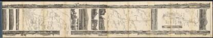
Mansfeldia Comitatus [Karte], in: Le théâtre du monde, ou, Nouvel atlas contenant les chartes et descriptions de tous les païs de la terre, Bd. 1, S. 193.
1 Karte aus Atlas Blaeu, Willem Janszoon und Blaeu, Joan Blaeu, Willem Janszoon
Mansfeldiae Comitatus Descriptio. [Karte], in: Theatrum orbis terrarum, S. 222.
1 Karte aus Atlas Ortelius, Abraham Vrients, Jan Baptista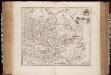
Mansfeldia comitatvs / auctore Tilemanno Stella sig
1 : 170000 Annotatie: Origineel is Blad 99 in atlas factice; Annotatie geografische gegevens: Schaalvermelding op kaart: 2 Milliaria Germanica communia; Kaart toont het graafschap Mansfeld in het gebied tussen Aschersleben, Halle an der Saale, Wiehe Unstruttal en Stolberg Tilemann Stella 1525-1589 [Amsterdami : apud Guiljelm. Blaeu]
Mansfeldia Comitatus [Karte], in: Theatrum orbis terrarum, sive, Atlas novus, Bd. 1, S. 245.
1 Karte aus Atlas Blaeu, Joan Blaeu, Willem Janszoon
Mansfeldiae Comitatus Descriptio. [Karte], in: Theatrum orbis terrarum, S. 130.
1 Karte aus Atlas Ortelius, Abraham
MANSFELDIA | COMITATVS
Auctore Tilemanno Stella Sig. Apud Guiljelm. Blaeu.
Comitatus Mansfeldia [Karte], in: Gerardi Mercatoris et I. Hondii Newer Atlas, oder, Grosses Weltbuch, Bd. 1, S. 289.
1 Karte aus Atlas Mercator, Gerhard und Hondius, Jodocus Jansson, Jan
Halle 73, uit: Special-Karte von Mittel-Europa / nach amtlichen Quellen bearbeitet von W. Liebenow
1 : 300000 titelvariant: W. Liebenow's Mittel-Europa; Annotatie: Titel boven de bladen: W. Liebenow's Mittel-Europa Johannes Wilhelm Liebenow 1822-1897 Frankfurt a. M. : Ludwig Ravenstein

Mansfeldia Comitatvs
1 : 170000 Mollova mapová sbírka Stella, Tilemann Blaeu, Joan I.
Mansfeldia Comitatvs
1 : 240000 Mollova mapová sbírka Merian, Matthaeus Merian, Matthäus
Comitatvs Mansfeldiae Descriptio
1 : 210000 Mollova mapová sbírka Stella, Tilemann Schenk, Peter I
Comitatvs Mansfeldiae Descriptio
1 : 210000 Mollova mapová sbírka Stella, Tilemann Janssonius, Johannes I
Mansfeldiae Comitatvs descriptio auctore Tilemanno Stella Sig.
1 : 180000 Mollova mapová sbírka Stella, Tilemann Hogenberg, Franz Braun, Georg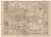
Mansfeldici comitatus typus chorographicus
1 : 180000 Halle an der Saale-oblast (Německo) Stella, Tilemann Mansfeld, Bruno a M. Iohanne Mellingero
Accurate Geographische Delineation der Graffschafft Mannsfelt Sowohl Char Sächsisch: als Brandenb. Hoheit
1 : 120000 Mollova mapová sbírka Mol, Pieter Schenk, Peter II
Delineatio geographica Comitatus Mansfeldensis
1 : 120000 Mollova mapová sbírka Seutter, Matthäus Seutter, Matthäus
Mansfeldiae comitatvs descriptio
1 Karte : Kupferdruck ; 36 x 41 cm Stella; Ortelius; Hogenberg s.n.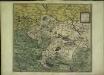
Mansfeldiae comitatvs descriptio
1 Karte : Kupferdruck ; 36 x 41 cm Stella; Ortelius; Hogenberg s.n.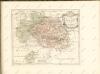

Comitatvs Mansfeld
1 : 110000 Mollova mapová sbírka Mayer, Tobias Biringius Homann, Johann Baptista - dědici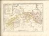

Accurate geographische Charte der Graeftlichen Stolbergl. AEmter, als Hohnstein, Stolberg, Hayn, Berenroda, Ebersburg, Wolfsberg, Ufftrungen, Rosla, und Questenb. nebst unterschiedliche angräntzenden
1 : 85000 Sasko (Německo) Schenk, Pieter P. Schenk
Besondere Land Karte des Herzogth. od. Chvrkreises Sachsen :
1 : 110000 Mollova mapová sbírka Homann, Johann Baptist Homann, Johann Baptista - dědici
101. Dessau, uit: Topographische Uebersichtskarte des Deutschen Reiches / herausgegeben v. d. Kartogr. Abt. d. Königl. Preuß. Landesaufnahme
1 : 200000 titelvariant: Topogr. Übersichtskarte des Deutschen Reiches; Annotatie: Titel boven bladen ook: Topogr. Übersichtskarte des Deutschen Reiches; Annotatie geografische gegevens: Op elk blad twee maatstokken: 10 Kilometer = 5,5 cm; 1 geogr. Meile = 3,6 cm; Legenda onder op elk blad Königlich Preußische Landesaufnahme. Kartographische Abtheilung [S.l : Königlich Preußische Landesaufnahme, Kartographische Abtheilung]
Halle und Eisleben
Geologischer Atlas zur Naturgeschichte der Erde Leonhard, Carl Cäsar von E. Schweizerbart'sche Verlagsbuchhandlung
Accurate Geographische Charte dar Graeslichen Stolbergl. als Hohnstein, Stolberg, Hayn, Berenroda, Ebersburg, Ufftrungen, Rosla, und Questenb. nebst unterschiedliche angräntzenden
1 : 90000 Mollova mapová sbírka Schenk, Pieter Schenk, Peter II
![Comitatus Mansfeldiae Descriptio. [Karte], in: Novus atlas absolutissimus, Bd. 2, S. 75.](https://images-2.georeferencer.com/images/iiif/076522834116/full/,300/0/native.jpg)

