Maps of Mansfeld-Südharz

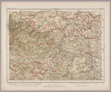
Halle 73, uit: Special-Karte von Mittel-Europa / nach amtlichen Quellen bearbeitet von W. Liebenow
1 : 300000 titelvariant: W. Liebenow's Mittel-Europa; Annotatie: Titel boven de bladen: W. Liebenow's Mittel-Europa Johannes Wilhelm Liebenow 1822-1897 Frankfurt a. M. : Ludwig Ravenstein
Comitatus Mansfeldiae Descriptio. [Karte], in: Novus atlas absolutissimus, Bd. 2, S. 75.
1 Karte aus Atlas Janssonius Offizin
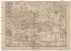
Comitatus Mansfeldia [Karte], in: Gerardi Mercatoris et I. Hondii Newer Atlas, oder, Grosses Weltbuch, Bd. 1, S. 289.
1 Karte aus Atlas Mercator, Gerhard und Hondius, Jodocus Jansson, Jan
Mansfeldia Comitatus [Karte], in: Le théâtre du monde, ou, Nouvel atlas contenant les chartes et descriptions de tous les païs de la terre, Bd. 1, S. 193.
1 Karte aus Atlas Blaeu, Willem Janszoon und Blaeu, Joan Blaeu, Willem Janszoon
Mansfeldia Comitatus [Karte], in: Novus Atlas, das ist, Weltbeschreibung, Bd. 1, S. 162.
1 Karte aus Atlas Blaeu, Joan Blaeu, Willem Janszoon
Mansfeldia Comitatus [Karte], in: Theatrum orbis terrarum, sive, Atlas novus, Bd. 1, S. 245.
1 Karte aus Atlas Blaeu, Joan Blaeu, Willem Janszoon
Mansfeldiae Comitatus Descriptio. [Karte], in: Theatrum orbis terrarum, S. 222.
1 Karte aus Atlas Ortelius, Abraham Vrients, Jan Baptista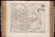
Mansfeldia comitatvs / auctore Tilemanno Stella sig
1 : 170000 Annotatie: Origineel is Blad 99 in atlas factice; Annotatie geografische gegevens: Schaalvermelding op kaart: 2 Milliaria Germanica communia; Kaart toont het graafschap Mansfeld in het gebied tussen Aschersleben, Halle an der Saale, Wiehe Unstruttal en Stolberg Tilemann Stella 1525-1589 [Amsterdami : apud Guiljelm. Blaeu]
MANSFELDIA | COMITATVS
Auctore Tilemanno Stella Sig. Apud Guiljelm. Blaeu.
Mansfeldiae Comitatus Descriptio. [Karte], in: Theatrum orbis terrarum, S. 130.
1 Karte aus Atlas Ortelius, Abraham

Mansfeldia Comitatvs
1 : 170000 Mollova mapová sbírka Stella, Tilemann Blaeu, Joan I.
Mansfeldia Comitatvs
1 : 240000 Mollova mapová sbírka Merian, Matthaeus Merian, Matthäus
Comitatvs Mansfeldiae Descriptio
1 : 210000 Mollova mapová sbírka Stella, Tilemann Schenk, Peter I
Comitatvs Mansfeldiae Descriptio
1 : 210000 Mollova mapová sbírka Stella, Tilemann Janssonius, Johannes I
Mansfeldiae Comitatvs descriptio auctore Tilemanno Stella Sig.
1 : 180000 Mollova mapová sbírka Stella, Tilemann Hogenberg, Franz Braun, Georg
Carté de la Principauté de Halberstadt
1 : 170000 Mollova mapová sbírka Riese, G. Hieronymus Homann, Johann Baptista - dědici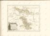
Mansfeldici comitatus typus chorographicus
1 : 180000 Halle an der Saale-oblast (Německo) Stella, Tilemann Mansfeld, Bruno a M. Iohanne Mellingero
Accurate Geographische Delineation der Graffschafft Mannsfelt Sowohl Char Sächsisch: als Brandenb. Hoheit
1 : 120000 Mollova mapová sbírka Mol, Pieter Schenk, Peter II
Delineatio geographica Comitatus Mansfeldensis
1 : 120000 Mollova mapová sbírka Seutter, Matthäus Seutter, Matthäus
Mansfeldiae comitatvs descriptio
1 Karte : Kupferdruck ; 36 x 41 cm Stella; Ortelius; Hogenberg s.n.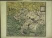
Mansfeldiae comitatvs descriptio
1 Karte : Kupferdruck ; 36 x 41 cm Stella; Ortelius; Hogenberg s.n.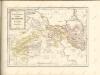

Routenkarte
1 : 150000 Dammann, W. Huch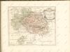

Comitatvs Mansfeld
1 : 110000 Mollova mapová sbírka Mayer, Tobias Biringius Homann, Johann Baptista - dědici
Charte von dem Harz Gebirge und einem Theile der umliegenden Gegenden
1 : 200000 Harz (Německo) Julius, Friedrich Berghaus, Heinrich Karl Wilhelm C.W. Ramdohr's Hof-Kunsthandlung
[Kaart], uit: Geognostische Übersichtskarte des Harzgebirges / zsgest. von K.A. Lossen
1 : 100000 Annotatie geografische gegevens: Samengest. naar opnamen van de Geologische Landesanstalt en oudere geologische kaarten, op basis van de Auhagen'sche topographischen Karte 1:100.000 K.A. Lossen [S.l. : s.n.] / ([Berlin : Berliner Lithogr. Institut])