Maps of Netherlands

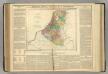
Belgii Veteris [Karte], in: Novus atlas absolutissimus, Bd. 3, S. 8.
1 Karte aus Atlas Janssonius Offizin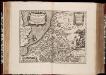
Belgii veteris typus : ex conatibus geographicis Abrahami Ortelij
1 : 1400000 Annotatie: Gegraveerd door Pieter van den Keere; De kaart geeft de Nederlanden weer in de tijd van de Romeinen; Origineel is Blad 33 in atlas factice; Kopie van de kaart van Abraham Ortelius uit 1584; Annotatie geografische gegevens: Met schaalstok Pieter van den Keere 1571-ná 1646; Abraham Ortelius 1527-1598 [Amsterdam : C.J. Visscher excudebat]
Belgii Veteris Typus [...] [Karte], in: Gerardi Mercatoris et I. Hondii Newer Atlas, oder, Grosses Weltbuch, Bd. 1, S. 361.
1 Karte aus Atlas Mercator, Gerhard und Hondius, Jodocus Jansson, Jan
Belgii Veteris Typus. [Karte], in: Theatrum orbis terrarum, S. 470.
1 Karte aus Atlas Ortelius, Abraham Vrients, Jan Baptista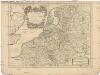
Les dix-sept provinces des Pays-Bas
1 : 1240000 Belgie Sanson, Guillaume Cordier, Louis chez H. Iaillot
Naauwkeurige kaart van het oude Nederland en eenige aangrenzende gewesten.
1 : 2000000 Isaak Tirion. Te Amsterdam : by Isaak Tirion
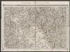
Belgii Veteris Typus. [Karte], in: Theatrum orbis terrarum, S. 377.
1 Karte aus Atlas Ortelius, Abraham

Niederland u. Belgien
1 : 2220000 Belgie Stein, Carl

Atlas für Handel und Industrie: Für Kaufleute, Fabrikante u. Gewerbetreibende, Handlungs- u. Gewerbe-Schulen
Belgii inferioris descriptio emendata cum circumiacentium regionum confiniis [Karte], in: Gerardi Mercatoris Atlas, sive, Cosmographicae meditationes de fabrica mundi et fabricati figura, S. 283.
1 Karte aus Atlas Mercator, Gerhard Montanus, Petrus
XVII provinciae Belgii sive Germaniae inferioris
1 : 1682000 Belgie Lotter, Tobias Conrad Rogg, Gottfried studio et opera Tobiae Conradi Lotter
XVII provinciae Belgii sive Germaniae inferioris
1 : 1682000 Belgie Lotter, Tobias Conrad Rogg, Gottfried opera Tobiae Conradi Lotter
XVII provinciae Belgii sive Germaniae inferioris
1 : 1682000 Belgie Lotter, Tobias Conrad Rogg, Gottfried T. C. Lotter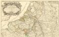
Theatre de la Guerre en Allemagne et dans les Pays Bas.
1 : 1100000 Mollova mapová sbírka Nolin, Jean-Baptiste Nolin, Jean-Baptiste I.
Bez titulu: Severozápadní Evropa
Netherlands.
1 : 1950000 Lavoisne, M.
Leo Belgicus / Johan van Doetechum fecit
1 : 350000 Annotatie: Facs. van de uitg.: [Amsterdam] : C.J. Visscher excudit, 1650. - Het betreft de 3e staat van de kaart van J. van Doetechum uit 1598, bijgewerkt door C.J. Visscher; Uitg. t.g.v. de tentoonstelling "De wereld op papier", in het Amsterdams Historisch Museum, april 1967 Joannes van Doetecum de Oudere -1605; Visscher, Claes Jansz. [S.l. : s.n.]
Europe Centrale (Partie Occidentale).
1 : 1750000 Jouvet et Cie.
Nouvelle Carte du Royaume des Pays - Bas et Pays Limithropes...


Unsere Westgrenze
1 : 1000000 Evropa západní Velhagen & Klasing
Homannův atlas světa
1 : 7000000
Nova mappa geographica Belgii universi seu Inferioris Germaniae quam XVII Provinciae, Austriaco, Gallico et Batavo sceptro parentes constituunt
1 : 1000000 cura et sum[p]tibus Joh: Michaelem Probst Aug. Vind. Aug. Vind : J.M. Probst
[Recto], uit: Descriptio Germaniae Inferioris
1 : 1000000 Annotatie: Waarschijnlijk gegraveerd door F. Hogenberg; Uit: Theatrum Orbis Terrarm. - Antwerpen, 1570 Hogenberg, Franz [Antwerpen : Abraham Ortelius]
Tabula generalis totius Belgii
1 : 1000000 Belgie Homann, Johann Baptist á Iohanne Baptista Homanno
TABULA GENERALIS TOTIUS BELGII qua PROVINCIAE XVII. INFER. GERMANIAE olim sub S.R.I. CIRCULO BURGUNDIAE
1 : 1100000 Belgie Homann, Johann Baptist â Iohanne Baptista Homanno
Tabula generalis totius Belgii
1 : 1000000 Belgie Homann, Johann Baptist á Iohanne Baptista Homanno
![Belgii Veteris [Karte], in: Novus atlas absolutissimus, Bd. 3, S. 8.](https://images-2.georeferencer.com/images/iiif/203062160904/full/,300/0/native.jpg)

