Maps of Castile and León

Utriusque Castiliae nova descriptio. [Karte], in: Novus Atlas, das ist, Weltbeschreibung, Bd. 2, S. 231.
1 Karte aus Atlas Blaeu, Joan Blaeu, Willem Janszoon
Utriusque Castiliae nova descriptio. [Karte], in: Le théâtre du monde, ou, Nouvel atlas contenant les chartes et descriptions de tous les païs de la terre, Bd. 2, S. 224.
1 Karte aus Atlas Blaeu, Willem Janszoon und Blaeu, Joan Blaeu, Willem Janszoon
Utriusque Castilliae nova descriptio. [Karte], in: Theatrum orbis terrarum, sive, Atlas novus, Bd. 2, S. 231.
1 Karte aus Atlas Blaeu, Joan Blaeu, Willem Janszoon
Utriusque Castiliae nova descriptio. [Karte], in: Novus atlas absolutissimus, Bd. 6, S. 40.
1 Karte aus Atlas Janssonius Offizin
Utriusque Castiliae nova descriptio
1 : 1700000 Annotatie: Oorspr. verschenen in: Novus atlas ... - Amsterdami : apud Guiljelmum Blaeu, 1635; Origineel is Blad 8 in atlas factice Blaeu, Willem Jansz. [Amsterdam : W.J. Blaeu]

Castiliae Veteris Et Novae Descriptio Anno 1606. [Karte], in: Gerardi Mercatoris et I. Hondii Newer Atlas, oder, Grosses Weltbuch, Bd. 2, S. 195.
1 Karte aus Atlas Mercator, Gerhard und Hondius, Jodocus Jansson, Jan
Vtrivsqve Castiliæ nova descriptio
1 Karte : Kupferdruck ; 40 x 49 cm Janssonius Joannes Janssonius
Vtrivsqve Castiliæ nova descriptio
1 Karte : Kupferdruck ; 39 x 48 cm Schenk; Janssonius; Valck apud G. Valk et P. Schenk
Vtrivsqve Castiliæ nova descriptio
1 Karte : Kupferdruck ; 40 x 49 cm Blaeu; Blaeu bey Ioh. und Cornelio Blaeu
VTRIVSQVE | CASTILIÆ | nova descriptio.
[Amsterdam : Joan Blaeu]

Castiliæ veteris et novæ descriptio
1 Karte : Kupferdruck ; 34 x 48 cm Hondius; Mercator Jodocus Hondius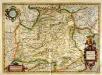
Castiliæ veteris et novæ descriptio
1 Karte : Kupferdruck ; 34 x 48 cm Mercator; Hondius Henricus Hondius
Castilliae Veteris Et Novae Descriptio [Karte], in: Gerardi Mercatoris Atlas, sive, Cosmographicae meditationes de fabrica mundi et fabricati figura, S. 183.
1 Karte aus Atlas Mercator, Gerhard Montanus, Petrus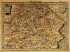
Castiliæ veteris et novæ descriptio
1 Karte : Kupferdruck ; 17 x 24 cm Mercator Cloppenburgh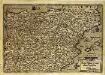
Regni Hispaniae post omium editiones locupletissima descriptio
1 Karte : Kupferdruck ; 18 x 27 cm Quad; Nagel; Bussemacher Johannes Bussemacher
La Castille vieille et nouvelle avec l'Estremadure
1 Karte : Kupferdruck ; 44 x 53 cm Nolin; Rousseau; Silva; Julien chez le Sr. Julien a l'hotel de soubise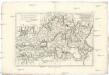
Castille Nouvelle, et r. de Valence
1 : 7660000 Kastilie (Španělsko) Bonne, Rigobert André
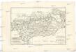
Partie, l'Espagne, Portugal. Europe 24.
1 : 1641836 Vandermaelen, Philippe, 1795-1869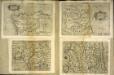
Castilia Estremadvra Æsturie Nauarra
1 Karte : Kupferdruck ; 15 x 21 cm Lambert Andreae
Spanien westliche Hälfte
Grosser Hand-Atlas über alle Theile der Erde in 170 Karten Meyer, J. Verlag des Bibliographischen Instituts
39-40. Spagna, Portogallo ouest.
1 : 1500000 Touring club italiano
Regnorum Castellæ novæ, Andalusiæ, Granadæ Valentiæ, et Murciæ accurata tabula, in episcopatus etc. divisa
1 Karte : Kupferdruck ; 48 x 58 cm Wit ex officina I. Cóvens et C. Mortier
Regnorum Castellæ novæ, Andalusiæ, Granadæ Valentiæ, et Murciæ accurata tabula, in episcopatus etc. divisa
1 Karte : Kupferdruck ; 48 x 58 cm Wit Frederick de Wit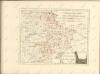
L'Andalousie avec les royaumes de Grenade et de Murcie
1 : 7660000 Andalusie (Španělsko) Bonne, Rigobert André
Partie meridionale des etats de Castille
1 Karte : Kupferdruck ; 46 x 53 cm Robert de Vaugondy; Santini; Remondini chez M. Remondini
Partie meridionale des etats de Castille
1 Karte : Kupferdruck ; 47 x 54 cm Robert de Vaugondy G. et D. Robert de Vaugondy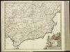
![Utriusque Castiliae nova descriptio. [Karte], in: Novus Atlas, das ist, Weltbeschreibung, Bd. 2, S. 231.](https://images-2.georeferencer.com/images/iiif/109886277313/full/,300/0/native.jpg)

