Maps of Appennini

Stato Della Chiesa, Con La Toscana. [Karte], in: Theatrum orbis terrarum, sive, Atlas novus, Bd. 3, S. 137.
1 Karte aus Atlas Blaeu, Joan Blaeu, Willem Janszoon
Stato Della Chiesa, Con La Toscana. [Karte], in: Novus Atlas, das ist, Weltbeschreibung, Bd. 3, S. 157.
1 Karte aus Atlas Blaeu, Joan Blaeu, Willem Janszoon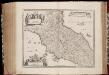
Stato della Chiesa con la Toscana
1 : 1035000 Annotatie: Met opdracht van Henricus Hondius; Origineel is Blad 162 in atlas factice; Annotatie geografische gegevens: Schaalstokken op de kaart: 60 Milliaria Italica communia (=10 cm), en: 12 Milliaria Germanica communia (=8,6 cm) Amstelodami : Sumptibus Ioannis Ianssonii
Italy. North Part.
1 : 2500000 Mitchell, Samuel Augustus
Stato Della Chiesa. Dominium Ecclesiasticum In Italia. [Karte], in: Gerardi Mercatoris et I. Hondii Newer Atlas, oder, Grosses Weltbuch, Bd. 2, S. 299.
1 Karte aus Atlas Mercator, Gerhard und Hondius, Jodocus Jansson, Jan
Northern Italy.
1 : 1270000 Mitchell, Samuel Augustus
Northern Italy.
1 : 1270000 Mitchell, Samuel Augustus
Stato Della Chiesa Con La Toscana [Karte], in: Novus atlas absolutissimus, Bd. 5, S. 142.
1 Karte aus Atlas Janssonius Offizin
Italy, North Part.
1 : 2500000 Tanner, Henry S.
Italy. North Part.
1 : 2450000 Tanner, Henry S.
Italy North Part.
1 : 2450000 Tanner, Henry S.
Northern Italy.
1 : 3168000 Tallis, J. & F.
Stato Della Chiesa, Con La Toscana. [Karte], in: Le théâtre du monde, ou, Nouvel atlas contenant les chartes et descriptions de tous les païs de la terre, Bd. 3, S. 165.
1 Karte aus Atlas Blaeu, Willem Janszoon und Blaeu, Joan Blaeu, Willem Janszoon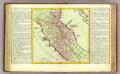
Etat de l'Eglise.
1 : 1500000 Clouet, J. B. L. (Jean-Baptiste Louis), b. 1730
STATO DELLA | CHIESA | CON LA TOSCANA
Guiljelmus Blaeu | excudit
Italiae pars borealis.
1 : 6000000 Fenner, Rest.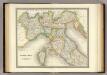
North Italy.
1 : 1950000 Teesdale, Henry
Florenz
1 : 1500000 Itálie severní K. u. k. Militärgeograph. Institute
Ober- und Mittel-Italien
Hand-Atlas über alle Theile der Erde und über das Weltgebäude Stieler, Adolf Justus Perthes
Ober- und Mittel-Italien
Handatlas über alle Theile der Erde und über das Weltgebäude Stieler, Adolf Justus Perthes
Ober und Mittel-Italien
1 : 1200000 Itálie severní Kiepert, Heinrich Gräf, C. Geographisches Institut
Ober und Mittel-Italien
1 : 1200000 Itálie severní Kiepert, Heinrich Gräf, Carl Geographisches Institut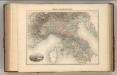
Italie Septentriole.
1 : 1940000 Migeon, J.
Ober, Mittel-Italien.
1 : 1200000 Kiepert, Heinrich, 1818-1899
Composite XI, XII, XVI, XVII: Karte Des Oesterreichischen Kaiserstaates.
1 : 576000 Scheda, Josef
Northn. Italy.
1 : 6000000 Fenner, Rest.
Italy middle, upper.
1 : 1100000 Robert Laurie & James Whittle
Gallia Cisalpina et Italia Propria
1 : 2200000 Mollova mapová sbírka Weigel, Christoph Weigel, Christoph I.
Ober-Und Mittel-Italien.
1 : 1850000 Petermann, A.
![Stato Della Chiesa, Con La Toscana. [Karte], in: Theatrum orbis terrarum, sive, Atlas novus, Bd. 3, S. 137.](https://images-2.georeferencer.com/images/iiif/001061733133/full/,300/0/native.jpg)

