Maps of China

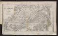
Tartaria sive Magni Chami Imperium [Karte], in: Gerardi Mercatoris et I. Hondii Newer Atlas, oder, Grosses Weltbuch, Bd. 2, S. 353.
1 Karte aus Atlas Mercator, Gerhard und Hondius, Jodocus Jansson, Jan
Standorte der höheren Kommandos in Asien
Russland Russland / Asiatischer Teil Militär
地理志略:亞西亞
地理志略 1903年,Alice S. Parker 此为用厦门闽南方言表述、罗马拼音书写的世界地理介绍性著作,介绍了清朝地理和世界六大洲地理概况。内有《大清國》图和《十八省》图,分别为全清和内地省级行政区划图。 2图,彩色,厦门方言罗马拼音,19.8 x 22.8 cm Harvard-Yenching | Rare Book | TA 2380 68.1,Hollis Number:008161905
Karte des Asiatischen Russland's und der angrenzenden Theile von Inner Asien
Zentralasien, Russland / Asiatischer Teil
t Russische Ryk zoo in Europa als in Asia, volgens de nieuwste ontdekkingen
1 : 48000000 [S.l.] : [s.n.]
Imperii Russici et Tatariae universae tam majoris et Asiaticae, qvam minoris et Europaeae tabvla
1 : 17200000 Asie Hase, Johann Matthias Schneider, R.A. impensis Homannianorum Heredum
IMPERII RUSSICI et TATARIAE UNIVERSAE tam majoris et Asiaticae, qvam minoris et Europaeae TABVLA
1 : 17200000 Asie Hase, Johann Matthias impensis Homannianorum Heredum
Magnae Tartariae, Magni Mongolis Imperii, Iaponiae et Chinae / [Frederick de Wit]
1 : 13000000 1 Karte : Kupferdruck ; 42 x 53 cm Wit, Frederick de by Frederick de Wit Voor aen'inde Calverstraet by den Dam Witte Pascaart
Tabula Tartariae et majoris partis regni Chinae / edita a F. de Wit ; Lhuilier fecit
1 : 13000000 1 Karte : Kupferdruck ; 42 x 53 cm L'Huilier, Jan by Frederick de Wit voor aen inde Calverstraet by den Dam inde Witte Pascaart
Map of the Siberian railway
Russland Sibirien Eisenbahnnetz Philip, George ; Philip, [Sohn v. G.]
Tartaria sive Magnichami Imperium [Karte], in: Novus atlas absolutissimus, Bd. 6, S. 116.
1 Karte aus Atlas Janssonius Offizin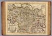
Carte de Tartarie.
1 : 10700000 L'Isle, Guillaume de, 1675-1726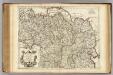
Carte de Tartarie.
1 : 10700000 L'Isle, Guillaume de, 1675-1726
Generalis totius Imperii Russorum Novissima Tabula Magnam Orbis terrarum partem a Polo Arctico uso ad mare Iaponicum et Chinae Septentrionalis confinia/exhibens cum via Czaricae nuper Legationis ex urbe Moscua per universam Tartariam ad magnum Chinae Imperatorem ex conatibus Iohannis Baptistae Homanni
Russland, Sibirien Homann, Johann Baptist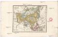
Asia
Asie Schmidt, Eduard Berra, Marco
Nord-& Mittel-Asien, Übersicht des Russischen Reiches
Handatlas über alle Theile der Erde und über das Weltgebäude Stieler, Adolf Justus Perthes
Nord- & Mittel-Asien, Übersicht des Russischen Reiches
Adolf Stieler's Handatlas über alle Theile der Erde und über das Weltgebäude Stieler, Adolf Justus Perthes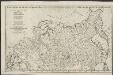
Partie de l'Empire de Russie comprise en Europe
1 : 6500000 par le Sr. d'Anville [S.l.] : [s.n.]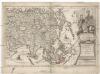
Asia multis in locis dei matrem colit, et vicißim multos favores ab illa accipit
Asie Scherer, Heinrich Ausfeld, Johann Carl
Asien
Asie Schmidt, Johann Marius Friedrich Franz Simon Schropp et Comp.
Tartaria sive Magni Chami Imperium [Karte], in: Novus Atlas, das ist, Weltbeschreibung, Bd. 2, S. 279.
1 Karte aus Atlas Blaeu, Joan Blaeu, Willem Janszoon
[Severní Amerika]
Severní Amerika Böhme, August Gottlob Hase, Johann Matthias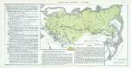
Nr. 17. Russlands neueste Entwicklung. - Japan 1895
Russland Expansion, Zentralasien
A new map of Great Tartary and China / Sutton Nicholls sculp. ; dedicated to William Duke of Glouces
1 : 15840000 1 Karte : Kupferdruck ; 35 x 49 cm Fer, Nicolas de s.a.
Tartaria sive Magni Chami imperivm
1 : 13000000 1 Karte : Kupferdruck ; 38 x 50 cm [Blaeu]
Tartaria sive Magni Chami imperiorum
1 : 14000000 1 Karte : Kupferdruck ; 25 x 33 cm Blaeu, Joan [Merian]
Tartaria sive Magni Chami imperiorum
1 : 14000000 1 Karte : Kupferdruck ; 25 x 33 cm Blaeu, Joan [Merian]
Generalis totius imperii Moscovitici novissima tabula / ex conatibus Iohannis Baptistae Homanni
1 : 12500000 1 Karte : Kupferdruck ; 47 x 54 cm Homann, Johann Baptist [Johann Baptist Homann]
![Tartaria sive Magni Chami Imperium [Karte], in: Gerardi Mercatoris et I. Hondii Newer Atlas, oder, Grosses Weltbuch, Bd. 2, S. 353.](https://images-2.georeferencer.com/images/iiif/328967525559/full/,300/0/native.jpg)

