Maps of Siberia

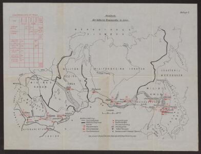
Standorte der höheren Kommandos in Asien
Russland Russland / Asiatischer Teil Militär
Magnae Tartariae, Magni Mongolis Imperii, Iaponiae et Chinae / [Frederick de Wit]
1 : 13000000 1 Karte : Kupferdruck ; 42 x 53 cm Wit, Frederick de by Frederick de Wit Voor aen'inde Calverstraet by den Dam Witte Pascaart
Tabula Tartariae et majoris partis regni Chinae / edita a F. de Wit ; Lhuilier fecit
1 : 13000000 1 Karte : Kupferdruck ; 42 x 53 cm L'Huilier, Jan by Frederick de Wit voor aen inde Calverstraet by den Dam inde Witte Pascaart
Karte des Asiatischen Russland's und der angrenzenden Theile von Inner Asien
Zentralasien, Russland / Asiatischer Teil

Tartaria sive Magni Chami Imperium [Karte], in: Gerardi Mercatoris et I. Hondii Newer Atlas, oder, Grosses Weltbuch, Bd. 2, S. 353.
1 Karte aus Atlas Mercator, Gerhard und Hondius, Jodocus Jansson, Jan
Russia in Asia and Tartary.
1 : 19500000 Mitchell, Samuel Augustus
Russia in Asia and Tartary.
1 : 19500000 Mitchell, Samuel Augustus
Imperii Russici et Tatariae universae tam majoris et Asiaticae, qvam minoris et Europaeae tabvla
1 : 17200000 Asie Hase, Johann Matthias Schneider, R.A. impensis Homannianorum Heredum
IMPERII RUSSICI et TATARIAE UNIVERSAE tam majoris et Asiaticae, qvam minoris et Europaeae TABVLA
1 : 17200000 Asie Hase, Johann Matthias impensis Homannianorum Heredum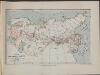
Map of the Siberian railway
Russland Sibirien Eisenbahnnetz Philip, George ; Philip, [Sohn v. G.]
Generalis totius Imperii Russorum Novissima Tabula Magnam Orbis terrarum partem a Polo Arctico uso ad mare Iaponicum et Chinae Septentrionalis confinia/exhibens cum via Czaricae nuper Legationis ex urbe Moscua per universam Tartariam ad magnum Chinae Imperatorem ex conatibus Iohannis Baptistae Homanni
Russland, Sibirien Homann, Johann Baptist
Nord-& Mittel-Asien, Übersicht des Russischen Reiches
Handatlas über alle Theile der Erde und über das Weltgebäude Stieler, Adolf Justus Perthes
Atlas für Handel und Industrie: Für Kaufleute, Fabrikante u. Gewerbetreibende, Handlungs- u. Gewerbe-Schulen
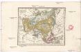
Asia
Asie Schmidt, Eduard Berra, Marco
t Russische Ryk zoo in Europa als in Asia, volgens de nieuwste ontdekkingen
1 : 48000000 [S.l.] : [s.n.]
Asien
Asie Schmidt, Johann Marius Friedrich Franz Simon Schropp et Comp.
Nord- & Mittel-Asien, Übersicht des Russischen Reiches
Adolf Stieler's Handatlas über alle Theile der Erde und über das Weltgebäude Stieler, Adolf Justus Perthes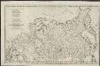
Partie de l'Empire de Russie comprise en Europe
1 : 6500000 par le Sr. d'Anville [S.l.] : [s.n.]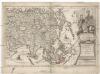
Asia multis in locis dei matrem colit, et vicißim multos favores ab illa accipit
Asie Scherer, Heinrich Ausfeld, Johann Carl
Tartaria sive Magni Chami Imperium. [Karte], in: Theatrum orbis terrarum, sive, Atlas novus, Bd. 2, S. 264.
1 Karte aus Atlas Blaeu, Joan Blaeu, Willem Janszoon
[Severní Amerika]
Severní Amerika Böhme, August Gottlob Hase, Johann Matthias
Ethnographische Karte des Asiatischen Russlands
Russland Russland / Asiatischer Teil Ethnische Gruppe
Magnae Tartariae, magni Mogolis imperii, Japoniae et Chinae, nova descriptio
1 : 15000000 ex tabula ampliss. viri D. N. Witsen pro majori parte aliis auctoribus excerpta et dita per F. De Witt Amstelodami London : sold by Christopher Browne at ye Globe at the west end of Saint Paulls' Church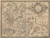
Tartariae Sive Magni Chami Regni tÿpus [Karte], in: Theatrum orbis terrarum, S. 390.
1 Karte aus Atlas Ortelius, Abraham Vrients, Jan Baptista
Charte von Asien
Asie Burmester, J. W. Ausfeld, Johann Carl
Tartaria sive Magni Chami imperivm
1 : 13000000 1 Karte : Kupferdruck ; 38 x 50 cm [Blaeu]
Tartaria sive Magni Chami imperiorum
1 : 14000000 1 Karte : Kupferdruck ; 25 x 33 cm Blaeu, Joan [Merian]
Tartaria sive Magni Chami imperiorum
1 : 14000000 1 Karte : Kupferdruck ; 25 x 33 cm Blaeu, Joan [Merian]