Maps of Baden-Württemberg
Totius Sueviae novissima Tabula [Karte], in: Gerardi Mercatoris et I. Hondii Newer Atlas, oder, Grosses Weltbuch, Bd. 1, S. 238.
1 Karte aus Atlas Mercator, Gerhard und Hondius, Jodocus Jansson, Jan
Totius Sueviae novissima Tabula [Karte], in: Novus atlas absolutissimus, Bd. 2, S. 214.
1 Karte aus Atlas Janssonius Offizin
Sueviae Nova Tabula. [Karte], in: Le théâtre du monde, ou, Nouvel atlas contenant les chartes et descriptions de tous les païs de la terre, Bd. 1, S. 263.
1 Karte aus Atlas Blaeu, Willem Janszoon und Blaeu, Joan Blaeu, Willem Janszoon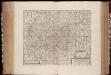
Totivs Sveviae novissima Tabvla
1 : 880000 Annotatie: Gegevens uitgever in cartouche linksonder sterk vervaagd; Origineel is Blad 119 in atlas factice; Vermelding in rechter bovenhoek: II; Annotatie geografische gegevens: Schaalstokken op kaart: Milliaria Germanica communia, en: Milliaria Gallica communia; In linker bovenhoek: legenda [Oxford] : [sumptibus Janssonio-Waesbergii, Mosis Pitt et Stephani Swart]
Sueviae Nova Tabula. [Karte], in: Novus Atlas, das ist, Weltbeschreibung, Bd. 1, S. 234.
1 Karte aus Atlas Blaeu, Joan Blaeu, Willem Janszoon
Sueviae Nova Tabula. [Karte], in: Theatrum orbis terrarum, sive, Atlas novus, Bd. 1, S. 277.
1 Karte aus Atlas Blaeu, Joan Blaeu, Willem Janszoon
Sveviae Nova Tabvla
1 : 880000 Mollova mapová sbírka Walter, Anton Walter, Anton
SVEVIÆ | NOVA | TABVLA.
[Amsterdam : Joan Blaeu]
La Souabe
1 Karte : Kupferdruck ; 39 x 40 cm Sanson chez l'autheur
Suevia Neue Land-Tafel des Gantzen Schwäbischen Krayses
1 : 880000 Mollova mapová sbírka Sandrart, Jakob von Sandrart, Jacob von
Svevia Tafel Schwaben
1 : 880000 Mollova mapová sbírka Merian, Matthaeus Merian, Matthäus st.
Sveviae Nova Tabvla
1 : 880000 Mollova mapová sbírka Blaeu, Willem Janszoon Blaeu, Willem Jansz.
Circvlvs Sveviae et ducatvs Wurtenbergensis
1 : 1270000 Württembersko (Německo)
Carte du comté de Tirol et des possessions de la maison d'Autriche dans le cercle de Souabe
1 : 1380000 Rakousko (1526-1804) Mentelle, Edme Tardieu, Pierre François
Totivs Sveviæ novissima tabvla
1 Karte : Kupferdruck ; 37 x 47 cm Janssonius ex officina Ioannis Ianssonii
Svevia
1 Karte : Kupferdruck ; 26 x 34 cm Merian Merian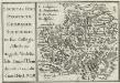
Societas Iesu Provinciae Germaniae Superioris in sua Collegia distributae
Mollova mapová sbírka Herz, Johann Daniel Herz, Johann Daniel
Le Cercle De Souabe subdivisé en tous les Estats qui le composent [Karte], in: Atlas nouveau, contenant toutes les parties du monde [...], Bd. 1, S. 280.
1 Karte aus Atlas Sanson, Nicolas Jaillot, Alexis Hubert und Mortier, Pieter
Circulus sive Liga Sueviae Vulgo Schwabische Kraiß. [Karte], in: Theatrum orbis terrarum, S. 274.
1 Karte aus Atlas Ortelius, Abraham Vrients, Jan Baptista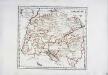
Der schwæbische Kreis
1 Karte : Kupferdruck ; 26 x 29 cm Reilly F. J. J. von Reilly


Circulus sive Liga Sueviae Vulgo Schwabische Kraiß. [Karte], in: Theatrum orbis terrarum, S. 179.
1 Karte aus Atlas Ortelius, Abraham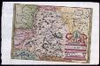
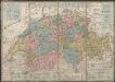
Provincia Helvetiae
Johannes a Montecalerio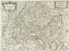
Il Circolo Di Svevia et il Langraviato D'Alsazia
1 : 650000 Mollova mapová sbírka Falda, Giovan Battista Widman, Giorgio De Rossi, Giovanni Giacomo
Le cercle de Souabe divisé en tous les estats qui le composent
1 Karte : Kupferdruck ; 44 x 60 cm Ottens; Jaillot; Ottens chez R. et J. Ottens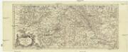
Totius fluminis Rheni novissima descriptio
Rýn, řeka-oblast Wit, Frederick de Frederick de Witt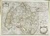
Le cercle de Souabe subdivisé en tous les estats qui le composent
1 Karte : Kupferdruck ; 45 x 64 cm Sanson; Jaillot; Cordier; Simonneau chez H. Iaillot geographe de sa Majesté joignant les grands Augustins aux 2 globes
Le cercle de Souabe divisé en tous les estats qui le composent
1 Karte : Kupferdruck ; 44 x 60 cm Jaillot Alexis-Hubert Jaillot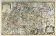
![Totius Sueviae novissima Tabula [Karte], in: Gerardi Mercatoris et I. Hondii Newer Atlas, oder, Grosses Weltbuch, Bd. 1, S. 238.](https://images-2.georeferencer.com/images/iiif/354148598490/full/,300/0/native.jpg)

