Maps of Switzerland

Regenkarte der Schweiz vom Jahre 1888
1 : 1000000 1 Karte entworfen von R. Kepler Wurster, Randegger & Co., Winterthur
Regenkarte der Schweiz vom Jahre 1887
1 : 1000000 1 Karte entworfen von R. Kepler Wurster, Randegger & Co., Winterthur
Regenkarte der Schweiz vom Jahre 1890
1 : 1000000 1 Karte entworfen von R. Kepler Wurster, Randegger & Co., Winterthur
Regenkarte der Schweiz vom Jahre 1889
1 : 1000000 1 Karte entworfen von R. Kepler Wurster, Randegger & Co., Winterthur
Regenkarte der Schweiz vom Jahre 1891
1 : 1000000 1 Karte entworfen von R. Kepler Wurster, Randegger & Co., Winterthur
Suisse
1 : 1200000 1 Karte par MM. Drioux et Ch. Leroy Librairie classique Eugène Belin, rue de Vaugirard, 52, Paris
Schweiz
1 : 1200000 1 Karte Perthes, Gotha
Regenkarte der Schweiz vom Jahre 1886
1 : 1000000 1 Karte entworfen von R. Kepler Wurster, Randegger & Co., Winterthur
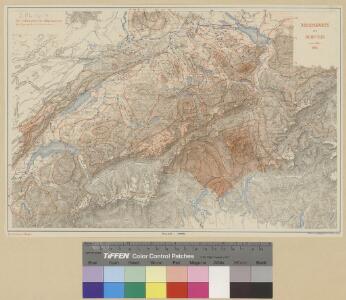
Carte pluviométrique de la Suisse établie d'après les relevés de toutes les stations de 1864-93
1 : 1000000 1 Karte par R. Billwiller Wurster, Randegger & Co., Winterthur
Eisenbahnkarte der Schweiz
1 : 800000 1 Karte hrsg. von H. Frei u. E. Tissot ; Wurster, Randegger & Co. Commissions-Verlag J. Wurster & Co., Zürich
J.H. Locher's Eisenbahnkarte der Schweiz
1 : 800000 1 Karte par [Johann Heinrich] Bachofen J.H. Locher, Zürich
Historisch-Geographischer Atlas der Schweiz in 15 Blättern
1 : 770000 Eidgenossenschaft 1803 - 1830 Voegelin, Johann Conrad ; Meyer von Knonau, Gerold ; Wyss, Georg von ; Meyer von Knonau, Gerold Schulthess
Keller's road map of Swisserland
1 : 480000 1 Karte J. Cary, Strand, [London]
<<La>> Suisse
1 : 800000 1 Karte nach H.K. [i.e. Heinrich Keller] Hch. Keller's geogr. Verlag, untere Zäune 23, Zürich
Switzerland and the Alps of Savoy & Piedmont
1 : 605000 1 Karte by Keith Johnston ; engraved & printed by W. & A.K. Johnston William Blackwood & Sons, Edinburgh
Keller's road map of Swisserland
1 : 480000 1 Karte G. and J. Cary, Strand, [London]
Keller's kleine Reisekarte der Schweiz
1 : 870000 1 Karte par [Henri] Keller Verlag von H. Keller, untre Zäune, Zürich
Carte de la Suisse à l'usage des écoles Suisses
1 : 850000 1 Karte dessinée et publiée par H. Keller = Charte der Schweiz für Schweizer Schulen / gezeichnet u. herausgegeben von H. Keller ; Lith. Brupbacher bey Heinrich Keller, Zürich
Eisenbahnkarte der Schweiz
1 : 800000 1 Karte nach offiziellen Angaben hrsg. von H. Frei und E. Tissot Wurster, Zürich
Eisenbahnen, Posten & Télégraphen Karte der Schweiz
1 : 850000 1 Karte F. Müllhaupt R. Leuthold's Geographischer Verlag, Zürich
Karte der Schweiz
1 : 760000 1 Karte Wurster, Winterthur
Schweiz
1 : 1000000 1 Karte bearbeitet von [Johannes] Randegger ; Topogr. Anstalt von Wurster, Randegger & Cie. in Winterthur Verlag der Erziehungs-Direction, Zürich
Schweiz
1 : 1000000 1 Karte Topogr. Anstalt von Wurster, Randegger & Cie., Winterthur
<<Les>> cantons des Suisses et leurs alliéz et leurs sujets
1 : 1400000 1 Karte [Chamereau], [Amsterdam]
<<La>> Suisse
1 : 800000 1 Karte Keller, Zürich
Übersicht des Landesgebiethes beider kriegführenden Theile
1 : 870000 1 Karte Topogr. Anstalt v. Joh. Wurster u. Comp. [Friedrich Schulthess], [Zürich]
Carte de la Suisse à l'usage des écoles Suisses
1 : 850000 1 Karte dessinée et publiée par H. Keller = Charte der Schweiz für Schweizer Schulen / gezeichnet u. herausgegeben von H. Keller H. Keller, Zürich
Schweiz
1 : 1000000 1 Karte [bearbeitet von Johannes Randegger] ; Topogr. Anstalt von Wurster, Randegger & Cie. in Winterthur Topogr. Anstalt von Wurster, Randegger & Cie. in Winterthur, Winterthur
<<La>> Suisse
1 : 800000 1 Karte Hch. Keller's geogr. Verlag, untere Zäune 23, Zürich