Maps of Switzerland

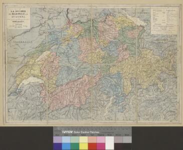
<<La>> Suisse
1 : 800000 1 Karte Hch. Keller's geogr. Verlag, untere Zäune 23, Zürich
<<La>> Suisse
1 : 800000 1 Karte Keller, Zürich
Übersicht des Landesgebiethes beider kriegführenden Theile
1 : 870000 1 Karte Topogr. Anstalt v. Joh. Wurster u. Comp. [Friedrich Schulthess], [Zürich]
Eisenbahnkarte der Schweiz
1 : 800000 1 Karte nach offiziellen Angaben hrsg. von H. Frey und E. Tissot Wurster, Zürich
Petite carte de la Suisse pour les écoles
1 : 800000 1 Karte gezeichnet und herausgegeben von H. Keller Heinrich Keller, untere Zäune No. 367, Zürich
Carte des chemins de fer de la Suisse
1 : 600000 1 Karte Hasler, Bâle
J.H. Locher's Eisenbahnkarte der Schweiz
1 : 800000 1 Karte par [Johann Heinrich] Bachofen J.H. Locher, Zürich
Karte der Schweiz für Schulen
1 : 800000 1 Karte von R. Leuzinger Verlag der J. Dalp'schen Buch & Kunsthandlung (Carl Schmid), Bern
Switzerland and the Alps of Savoy & Piedmont
1 : 605000 1 Karte by Keith Johnston ; engraved & printed by W. & A.K. Johnston William Blackwood & Sons, Edinburgh
Carte des routes et des relais de la poste-aux-chevaux de la Confédération Suisse
1 : 600000 1 Karte dressée à la Direction Générale des Postes ; Lith. Kümmerly & Wittmer Direction Générale des Postes, Berne
Karte der Schweiz für Schulen
1 : 800000 1 Karte von R. Leuzinger Verlag der Dalp'schen Buch- & Kunsthandlung, Bern
Eisenbahnkarte der Schweiz
1 : 800000 1 Karte hrsg. von H. Frei u. E. Tissot ; Wurster, Randegger & Co. Selbstverlag der Herausgeber, Bahnhof Zürich, Zürich
Karte von der Schweiz
1 : 850000 1 Karte gezeichnet und herausgegeben von Heinrich Keller ; Lith. von J. Schweizer Heinrich Keller, untre Zäune No. 367, Zürich
Eisenbahnkarte der Schweiz
1 : 800000 1 Karte hrsg. von H. Frei u. E. Tissot ; Wurster, Randegger & Co. [Verlag nicht ermittelbar], [Zürich]
Karte der Schweiz
1 : 800000 1 Karte von R. Leuzinger = Carte de la Suisse : chemins de fers / par R. Leuzinger Verlag der J. Dalp'schen Buchhandlung, Bern
Regenkarte der Schweiz vom Jahre 1890
1 : 1000000 1 Karte entworfen von R. Kepler Wurster, Randegger & Co., Winterthur
Keller's road map of Swisserland
1 : 480000 1 Karte G. and J. Cary, Strand, [London]
[Carte de la Suisse à l'usage des écoles Suisses]
1 : 850000 1 Karte [dessinée et publiée par H. Keller] = Charte der Schweiz für Schweizer Schulen [H. Keller], [Zürich]
Karte der Schweiz
1 : 800000 1 Karte R. Leuzinger J. Dalp'sche Buch & Kunsthandlung (C. Schmid), Bern
Schweiz
1 : 1200000 1 Karte Perthes, Gotha
Schweizerische Nationalbahn
1 : 600000 1 Karte Wurster, Winterthur
Keller's road map of Swisserland
1 : 480000 1 Karte J. Cary, Strand, [London]
Regenkarte der Schweiz vom Jahre 1887
1 : 1000000 1 Karte entworfen von R. Kepler Wurster, Randegger & Co., Winterthur
Karte der Schweiz
1 : 600000 1 Karte bearb. unter Mitwirkung hervorragender Schulmänner von J. Randegger Topogr. Anstalt Winterthur J. Schlumpf, vorm. Wurster, Randegger u. Co., Winterthur
Eisenbahnkarte der Schweiz
1 : 800000 1 Karte nach offiziellen Angaben hrsg. von H. Frei und E. Tissot Wurster, Zürich
[Karte der Schweiz]
1 : 380000 1 Karte auf 4 Bl. J.M. Ziegler Topogr. Anstalt v. J. Wurster u. Comp., Winterthur
<<La>> Suisse
1 : 800000 1 Karte Keller, Zürich
Karte der Schweiz
1 : 800000 1 Karte R. Leuzinger J. Dalp'sche Buch & Kunsthandlung (C. Schmid), Bern
Karte der Schweiz
1 : 800000 1 Karte R. Leuzinger J. Dalp'sche Buch & Kunsthandlung (Carl Schmid), Bern