Maps of Switzerland

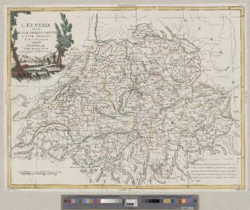
<<L'>>Elvezia divisa ne suoi tredici cantoni e suoi alleati
1 : 900000 1 Karte G. Zuliani inc. ; G. Pitteri scri. presso Antonio Zatta, Venezia
Kleine officielle Eisenbahnkarte der Schweiz
1 : 500000 1 Karte gest. von R. Leuzinger ; Schweizer. Post- und Eisenbahndepartement = Petite carte officielle des chemins de fer de la Suisse Kümmerly, Bern
Carte générale des trèze cantons de Suisse, Vallay, ligues Grise, Maison-Dieu & Valteline
1 : 725000 1 Karte [par Nicolas Berey] 1654 chez N. Langlois, rue S. Jacques à la Victoire, Paris
Carte routière et de poste de la Suisse divisée en ses 23 cantons, comprenant les pays sujets et les pays alliés de la Suisse
1 : 530000 1 Karte dressée par [Eustache] Hérisson Basset, Paris
Nova Helvetiae, foederatarumque cum ea, nec non subditarum regionum tabula, ad usum serenissimi Burgundiae ducis, secundum commentarios domini Merveilleux
1 Karte composita per Gulielmum de l'Isle apud Joh. Covens & Corn. Mortier, Amstelodami
<<La>> Suisse divisée en ses treize cantons et ses alliés
1 : 850000 1 Karte dressée par [Giovanni Antonio] Rizzi Zannoni chez Lattré, rue St Jacques, à la ville de Bordeaux, Paris
Nova Helvetiae tabula geographica, illustrissimis et potentissimis tredecin cantonibus confoederatis et subjectis provinciis consistentis
1 Karte per Fr. Lotter [Lotter?], [Augsburg?]
Uebersichtskarte aller am "Arbeiter-Secretariat" interessirten Vereine
1 : 500000 1 Karte gezeichnet und zu beziehen von G.M. Bay R. Müller-Tobler, Zürich
Novissima et accuratissima Helvetiae, Rhaetiae, Valesiae et partis Sabaudiae tabula
1 : 550000 1 Karte [Justus Danckerts der Ältere] ex officina Iusti Danckerts, Amst.

Charte der Schweiz in seine Cantone eingetheilt
1 : 520000 1 Karte [Johannes Walch] Joh. Walch, Augsburg
<<La>> république helvétique ou sont distingués les cantons qui la composent suivant les derniers décrets
1 : 500000 1 Karte dressée par H.M. [i.e. Henri Mallet] ; L. Emery sc. [Verlag nicht ermittelbar], [Genève]
Die Schweiz mit den projektierten Eisenbahnen; Übersichtskarte
Mit Legende. Ohne Datumsangabe. Joh. Wurster und Comp., in Winterthur
<<Les>> Suisses, leurs sujets et leurs alliéz
1 Karte corrigée et augmentée d'après les nouvelles observations de Ms. de l'Académie Royale des Sciences ; P. Starckman sculpsit chez Desnos, Rue St. Jacques au Globe, Paris
Karte der schweizerischen Zollämter
1 : 500000 1 Karte [Kartogr.:] Topogr. Anstalt Gebr. Kümmerly Schweizerisches Zolldepartement, Bern
Nouvelle carte de la Suisse divisées en ses treize cantons, ses alliéz et ses sujets
1 : 240000 1 Karte auf 4 Bl. par Jean Jacob Scheuchzer chez Jean Cóvens et Corneille Mortier, Amsterdam
Nova Helvetiae tabula
1 : 780000 1 Karte ex officina Iudoci Hondij F., Amstelodami
Übersichtskarte des schweizerischen Pegel- und Witterungsstationennetzes
1 : 600000 1 Karte Wurster, Winterthur
<<La>> Suisse divisée en ses treze cantons, ses alliéz & ses sujets
1 Karte par Sanson chez I Covens et C. Mortier, Amsterdam
Nova Helvetiae tabula geographica illustrissimis et potentissimis cantonibus et rebuspublicis reformatae religionis Tigurinae, Bernensi, Glaronensi, Basiliensi, Scaphusianae, Abbatis Cellanae
1 : 230000 1 Karte auf 4 Bl. dominis suis clementissimis humilime dicata a Ioh. Iacobo Scheuchzero Tigurino ; Ioh. Melch. Füsslin ornamenta pinx. ; Ioh. Henr. Huber et Eman. Schalch sculps. [Hofmeister], [Zürich]
Officielle Eisenbahnkarte der Schweiz
1 : 500000 1 Karte Kümmerly & Frey, Bern
<<La>> repubblica Elvetica eve si veggono colle rispettive loro divisioni i cantoni di cui è stata composta dopo gli ultimi decreti
1 : 500000 1 Karte spatta dal sig. H.M. [i.e. Henri Mallet] ingeg.e geografo ; Gius.e Pezze inc. [Verlag nicht ermittelbar], [Erscheinungsort nicht ermittelbar]
Schweizerische Zollkarte
1 : 500000 1 Karte Schweiz. Zolldepartement = Carte douanière de la Suisse / Département Fédéral des Douanes Commissions-Verlag von Schmid u. Francke, Bern
Helvetiae, Rhaetiae et Valesiae caeterorumque confoederatorum ut & finitimorum populorum tabula geographica et hydrographica nova & exacta
1 : 470000 1 Karte operâ & studio Ioh. Conradi Gygeri delineata & à Conrado Meyero in aes incisa, anno Christi 1657 [Verlag nicht ermittelbar], [Zürich]
Carte de la Suisse avec des noms en marge
1 : 850000 1 Karte gezeichnet und herausgegeben von Heinrich Keller ; [Lith. von Schweizer] Heinrich Keller, untre Zäune No. 367, Zürich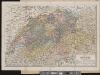
Carte de la Suisse
1 : 700000 1 Karte par W. Rosier ; Fernique, Ph. sc. Delachaux & Niestlé, Neuchâtel
Historischer Atlas der Schweiz
Politischer Zustand der Schweiz im Jahre 1300 Mandrot, Louis-Alphonse de Deutsche Buchhandlung von J. Kessmann
Carte de la Suisse à l'usage des écoles Suisses
1 : 850000 1 Karte dessinée et publiée par H. Keller = Charte der Schweiz für Schweizer Schulen / gezeichnet und herausgegeben von H. Keller H. Keller, Zürich
<<Die>> eidgenössische Volksabstimmung vom 4. November 1894 über die Zoll-Initiative
1 : 1200000 1 Karte [Kartogr.:] Lith. Gebr. Kümmerly, Bern Eidg. statist. Bureau, [Bern]