Maps of Switzerland

Carte routière et de poste de la Suisse divisée en ses 23 cantons, comprenant les pays sujets et les pays alliés de la Suisse
1 : 530000 1 Karte dressée par [Eustache] Hérisson Basset, Paris
Kleine officielle Eisenbahnkarte der Schweiz
1 : 500000 1 Karte gest. von R. Leuzinger ; Schweizer. Post- und Eisenbahndepartement = Petite carte officielle des chemins de fer de la Suisse Kümmerly, Bern
Die Schweiz mit den projektierten Eisenbahnen; Übersichtskarte
Mit Legende. Ohne Datumsangabe. Joh. Wurster und Comp., in Winterthur
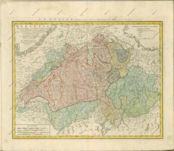
<<La>> république helvétique ou sont distingués les cantons qui la composent suivant les derniers décrets
1 : 500000 1 Karte dressée par H.M. [i.e. Henri Mallet] ; L. Emery sc. [Verlag nicht ermittelbar], [Genève]
Karte der schweizerischen Zollämter
1 : 500000 1 Karte [Kartogr.:] Topogr. Anstalt Gebr. Kümmerly Schweizerisches Zolldepartement, Bern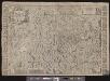
<<La>> Suisse divisée en ses treze cantons, ses alliéz & ses sujets
1 Karte par Sanson chez I Covens et C. Mortier, Amsterdam
<<La>> Suisse divisée en ses treize cantons et ses alliés
1 : 850000 1 Karte dressée par [Giovanni Antonio] Rizzi Zannoni chez Lattré, rue St Jacques, à la ville de Bordeaux, Paris
Schweizerische Zollkarte
1 : 500000 1 Karte Schweiz. Zolldepartement = Carte douanière de la Suisse / Département Fédéral des Douanes Commissions-Verlag von Schmid u. Francke, Bern
<<L'>>Elvezia divisa ne suoi tredici cantoni e suoi alleati
1 : 900000 1 Karte G. Zuliani inc. ; G. Pitteri scri. presso Antonio Zatta, Venezia
Officielle Distanzen- und Höhen-Karte der schweizerischen Eisenbahnen
1 : 500000 1 Karte Schweiz. Post- und Eisenbahndepartement Kümmerly, Bern
Novissima et accuratissima Helvetiae, Rhaetiae, Valesiae et partis Sabaudiae tabula
1 : 550000 1 Karte [Justus Danckerts der Ältere] ex officina Iusti Danckerts, Amst.
<<Der>> Helvetischen Republik neue Cantons und Districts Eintheilung
1 : 630000 1 Karte dem Vollziehungs-Directorium gewiedmet von Wilhelm Haas dem Sohne im Augstmonat 1798 Haas, Basel
<<Der>> Helvetischen Republik neue Cantons und Districts Eintheilung
1 : 630000 1 Karte dem Vollziehungs-Directorium gewiedmet von Wilhelm Haas dem Sohne im Augstmonat 1798 Haas, Basel
<<Die>> Helvetische Republik
1 : 1150000 1 Karte im Verlage des Land. Industrie Compt., Weimar
Nova Helvetiae tabula geographica, illustrissimis et potentissimis tredecin cantonibus confoederatis et subjectis provinciis consistentis
1 Karte per Fr. Lotter [Lotter?], [Augsburg?]
Geological map of Switzerland
1 : 800000 1 Karte by R. Leuzinger Anglo-Swiss Tourists Equipment Company, A. Ramsauer, [Erscheinungsort nicht ermittelbar]
Übersichtskarte des schweizerischen Pegel- und Witterungsstationennetzes
1 : 600000 1 Karte Wurster, Winterthur
Carte générale des trèze cantons de Suisse, Vallay, ligues Grise, Maison-Dieu & Valteline
1 : 725000 1 Karte [Nicolas Tassin] [chez Melchior Tavernier], [Paris]
Helvetia tredecim statibus liberis quos cantones vocant, composita, una cum foederatis & subjectis provinciis
1 : 650000 1 Karte ex probatissimis subsidiis geographice delineata per Tobiam Mayerum luci publicae tradita ab Homannianis Heredibus, Norimbergae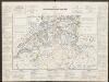
Historischer Atlas der Schweiz
Politischer Zustand der Schweiz im Jahre 1300 Mandrot, Louis-Alphonse de Deutsche Buchhandlung von J. Kessmann
Uebersichtskarte aller am "Arbeiter-Secretariat" interessirten Vereine
1 : 500000 1 Karte gezeichnet und zu beziehen von G.M. Bay R. Müller-Tobler, Zürich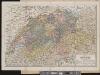
Carte de la Suisse
1 : 700000 1 Karte par W. Rosier ; Fernique, Ph. sc. Delachaux & Niestlé, Neuchâtel
Officielle Eisenbahnkarte der Schweiz
1 : 500000 1 Karte Kümmerly & Frey, Bern
Charte der Schweiz in seine Cantone eingetheilt
1 : 520000 1 Karte [Johannes Walch] Joh. Walch, Augsburg
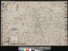
Nouvelle carte de la Suisse divisées en ses treize cantons, ses alliéz et ses sujets
1 : 240000 1 Karte auf 4 Bl. par Jean Jacob Scheuchzer chez Jean Cóvens et Corneille Mortier, Amsterdam
Officielle Eisenbahnkarte der Schweiz
1 : 500000 1 Karte Schweiz. Post- & Eisenbahndepartement = Carte officielle des chemins de fer de la Suisse Kümmerly, Bern
<<La>> Suisse divisée en ses treze canton, ses alliéz et ses sujets
1 : 1250000 1 Karte [Homännische Erben?], [Nürnberg?]
Potentissimae Helvetiorum reipublicae cantones tredecim cum foederatis et subjectis provinciis
1 : 580000 1 Karte exhibiti a Joh. Baptista Homanno Homann, Noribergae