Maps of Switzerland

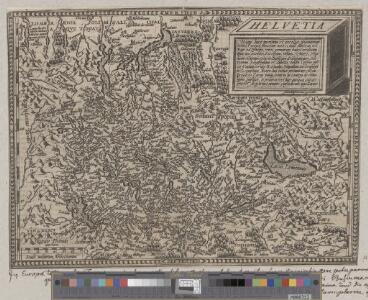
Helvetia
1 : 1400000 1 Karte Aegidio Tschudo auctore ; Johan Bussemecher excudit [ex officina Iani Bussemechers], [Coloniae]
Helvetiae conterminarumque terrarum antiqua descriptio
1 : 2000000 1 Karte [Stich von Girolamo Porro] ; [hrsg. von Giovanni Antonio Magini] [Verlag nicht ermittelbar], [Erscheinungsort nicht ermittelbar]
Helvetiae Descriptio [Karte], in: Theatrum orbis terrarum, S. 77.
1 Karte aus Atlas Ortelius, Abraham
Helvetia
1 : 4200000 1 Karte Aegidio Tschudo auctore [Compagnia Bresciana], [Brescia]
Entwerffung der ietzt-lebenden hochloblich- und hoechst beglueckten Eydgenossschafft
1 : 850000 1 Karte [Johannes Stumpf] [Verlag nicht ermittelbar], [Zürich?]
Entwerffung der ietzt-lebenden hochloblich- und hoechst beglueckten Eydgenossschafft
1 : 850000 1 Karte [Johannes Stumpf] [Verlag nicht ermittelbar], [Zürich?]
Helvetia
1 : 2500000 1 Karte [Philipp Clüver] [Verlag nicht ermittelbar], [Guelpherbyti]
Helvetia
1 : 1900000 1 Karte [Zacharias Heyns] [pour Zacharie Heyns, à l'Enseigne des trois vertus], [Amsterdam]
Helvetiae Descriptio [Karte], in: Theatrum orbis terrarum, S. 182.
1 Karte aus Atlas Ortelius, Abraham
Helvetiae Descriptio [Karte], in: Theatrum orbis terrarum, S. 277.
1 Karte aus Atlas Ortelius, Abraham Vrients, Jan Baptista
Suisse, or, Switzerland together with their allies & subjects etc
1 : 1500000 1 Karte by H. Moll [Verlag nicht ermittelbar], [London]
Schweizerkarte von 1570
1 : 1200000 1 Karte cop. von A. Züricher (Section Wildhorn) ; Lith. R. Armbruster, Bern [Verlag der Expedition des Jahrbuches des S.A.C.], [Bern]
[Helvetia]
1 Karte apud Vincentius Luchinus, Venetijs
Helvetia
1 : 2500000 1 Karte [appresso P. & F. Galignani], [Padova]
<<Die>> dreyzehend Tafel haltet inn ein Verzeichnung der loblichen Eydgnoschafft und irer Zuogewandten sampt dem Alpgebirg und nächsten Anstössen
1 : 900000 1 Karte [Johannes Stumpf] [Froschauer], [Zürich]
Suisse, or, Switzerland with their allies and subjects &c
1 : 1350000 1 Karte by H. Moll [printed for Thomas and John Bowles?], [London]
<<Die>> 19 Cantone der Vermittlungsakte von 1803-15
1 : 1700000 1 Karte Kartogr. Anstalt Hofer & Co., Zürich
[Helvetia]
1 : 700000 1 Karte auf 2 Bl. Paulus de Forlanis [Forlani], Venetij
Erste Post- & Dampfschifffahrt Reise Carte der Schweiz
1 : 750000 1 Karte entworfen, bearb. und einer hochloblichen Post-Commission der Stadt Basel ergebenst gewidmet von Hiers. Rumpf ; auf Stein gestochen von C. Bruder E. Hindermann's Witwe, Basel
Helvetia
1 : 4200000 1 Karte Aegidio Tschudo auctore [de l'Imprimérie de Christofle Plantin], [Anvers]
Suisse
1 : 1500000 1 Karte [Verlag nicht ermittelbar], [Erscheinungsort nicht ermittelbar]
Ansiedlung der Alamannen [und] Burgunder
1 : 1700000 1 Karte Kartogr. Anstalt Hofer & Co., Zürich
Helvetia, Eydtgnossschafft, oder Schweytzerlandt, mit dero Gräntzen
1 Karte formis Davidis Hautii, Lucerne Helvet.
Helvetia
1 : 2500000 1 Karte [ed.: Alphons Lasor a Varea] [Verlag nicht ermittelbar], [Patavii]
Verbreitungsweise der Alpen-Fündlinge
1 : 1200000 1 Karte Topogr. Anst. v. J. Wurster u. Comp. [Kiesling], [Zürich]
Helvetiae descriptio
1 : 900000 1 Karte Aegidio Tschudo auct. ; [Abraham Ortelius fecit] [apud Aegid. Coppenium Diesth], [Antverpiae]
Helvetia, Rhaetia, Valesia
1 : 580000 1 Karte labore et studio Henrici Ludovici Muoss bei dem Author, Zug
<<Die>> 8 alten Orte beim Abschluss des 50jährigen Friedens mit Oesterreich anno 1412
1 : 1700000 1 Karte Kartogr. Anstalt Hofer & Co., Zürich
General-Carte der Schweiz
1 : 1200000 1 Karte entworfen und gestochen von J. Scheurmann bey Orell Füssli & Compagnie, Zürich