Maps of Switzerland

Ansiedlung der Alamannen [und] Burgunder
1 : 1700000 1 Karte Kartogr. Anstalt Hofer & Co., Zürich
<<Die>> 8 alten Orte beim Abschluss des 50jährigen Friedens mit Oesterreich anno 1412
1 : 1700000 1 Karte Kartogr. Anstalt Hofer & Co., Zürich
Suisse
1 : 1500000 1 Karte [Verlag nicht ermittelbar], [Erscheinungsort nicht ermittelbar]
<<Die>> 19 Cantone der Vermittlungsakte von 1803-15
1 : 1700000 1 Karte Kartogr. Anstalt Hofer & Co., Zürich
Suisse, or, Switzerland with their allies and subjects &c
1 : 1350000 1 Karte by H. Moll [printed for Thomas and John Bowles?], [London]
Helvetia, Rhaetia, Valesia
1 : 580000 1 Karte labore et studio Henrici Ludovici Muoss bei dem Author, Zug
Helvetia, Rhaetia, Valesia
1 : 580000 1 Karte labore et studio Henrici Ludovici Muoss bei Joh. Jost Hiltensperger, Zug
Postkarte von der Schweiz
1 : 860000 1 Karte [Franz Johann Joseph von Reilly] ; gestochen von Johann Stenger im von Reilly'schen Landkarten und Kunstwerke Verschleiss Komtoir, Wien
General-Charte der Schweiz in XXII Cantone abgetheilt
1 : 1200000 1 Karte gez. u. gest. v. J. Scheurman bey Orell, Füssli und Compagnie, Zürich
Carte générale physique et routière des 22 cantons de la confédération Suisse
1 : 750000 1 Karte par A.H. Brué ; gravée sous la direction de l'auteur ; les montagnes gravées par Dandeleux Brué, Paris
Suisse
1 : 3600000 1 Karte V. Levasseur ; gravé par: Laguillermie [Bureaux du Journal des connaissances utiles], [Paris]
Tabula qua indicantur Confoederationis Helveticae loci in quibus tituli latini reperti sunt
1 : 1200000 1 Karte Topogr. Anstalt v. J. Wurster u. Comp., Winterthur
<<Die>> Schweiz
1 : 1754419 1 Karte bei I. P. Spehr, Braunschweig
Geologische Karte der Schweiz 1843
1 : 1210000 1 Karte gez. v. Max Daffner Verlag des Literarischen Comptoirs, Winterthur
Switzerland and the country of the Grisons wherein is described the XIII Switz Cantons with their allies &c
1 Karte revised by I. Senex [Verlag nicht ermittelbar], [Erscheinungsort nicht ermittelbar]
[Helvetia]
1 : 900000 1 Karte Gaspar Baldouino ; Paulus Slella picto. [Baldouin], Mediolani
Carte der Schweiz zu dem kleinen Atlass mit Beschreibung der Merkwürdigkeiten der Schweiz
1 : 900000 1 Karte [Verlag nicht ermittelbar], [Erscheinungsort nicht ermittelbar]
Helvetia, Rhaetia, Valesia
1 : 580000 1 Karte labore et studio Henrici Ludovici Muoss bei dem Author, Zug
Erste Post- & Dampfschifffahrt Reise Carte der Schweiz
1 : 750000 1 Karte entworfen, bearb. und einer hochloblichen Post-Commission der Stadt Basel ergebenst gewidmet von Hiers. Rumpf ; auf Stein gestochen von C. Bruder E. Hindermann's Witwe, Basel
Carte de Suisse et de Savoye
1 : 2000000 1 Karte [par Claude Buffier] [Giffart], [Paris]
Helvetia, Eydtgnossschafft, oder Schweytzerlandt, mit dero Gräntzen
1 Karte formis Davidis Hautii, Lucerne Helvet.
[Helvetia]
1 Karte Dominicus Zenoi V. excindebat apud Ferdinando Berteli, Venetija
1e. carte de Suisse
1 : 700000 1 Karte [par Jean Palairet] [chez Mess. J. Nourse & P. Vaillant dans le Strand], [Londres]
Helvetia
1 : 2500000 1 Karte [Giovanni Antonio Magini aut.] ; [Girolamo Porro sculp.] [Haeredes Simones Galignani], [Venezia]
General-Charte der Schweiz in XXII Cantone abgetheilt
1 : 1200000 1 Karte gez. u. gest. v. J. Scheurman bey Orell, Füssli und Compagnie, Zürich
Carte générale de la Suisse
1 : 850000 1 Karte par Clermont 1781 ; Perrier sculp. [de l'Imprimerie de Clousier, rue Saint-Jacques], [Paris]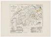
Historisch-geographischer Atlas der Schweiz: Karte XV: Schweizerische Sprachkarte nach der Volkszählung 1860
Mit Angabe der Orte mit über 2000 Einwohnern. Bearbeitung: Vögelin, J. K.; Meyer von Knonau, G.
<<Die>> Mineral-Quellen der Schweiz und ihrer nächsten Umgebungen
1 : 1200000 1 Karte Topogr. Anst. v. J. Wurster u. Comp. [Naturforschende Gesellschaft?], [Zürich?]
Schweizerkarte von 1570
1 : 1200000 1 Karte cop. von A. Züricher (Section Wildhorn) ; Lith. R. Armbruster, Bern [Verlag der Expedition des Jahrbuches des S.A.C.], [Bern]
![Ansiedlung der Alamannen [und] Burgunder](https://images-2.georeferencer.com/images/iiif/458453289929/full/,300/0/native.jpg)

