Maps of Bezirk Andelfingen

[Region Winterthur-Schaffhausen]
1 : 120000 1 Karte Lith. v. C.G. Wenng
Eigentliche Verzeichnuss der Stätten, Graffschaften und Herrschaften, welche in der Statt Zürich Gebiet und Landschaft gehörig sind
1 : 56000 1 Karte auf 16 Bl. gerissen durch Josen Murern
Nr. 2: Militärquartier Trüllikon; Übersichtskarte
1 : 43500 Originaltitel: Dess Trüllicker Quartiers, sampt den anstössen anderer Landschafften, vnd Quartieren, Eigentlicher Grundriss vnd gewüsse Verzeichnuss. Gyger, Hans Conrad, andere Schreibweisen: Geiger, Geyger, (1599-1674), Kartograf, Ingenieur und Amtmann des Amts Kappelerhof, von Zürich
Nr. 2: Militärquartier Trüllikon; Übersichtskarte von 1660
Handgezeichnete Kopie der von Hans Conrad Gyger, andere Schreibweisen: Geiger, Geyger, (1599-1674), Kartograf, Ingenieur und Amtmann des Amts Kappelerhof, von Zürich, verfertigten Originalkarte. Ohne Datumsangabe. Spitteler, Sigmund (1732-1818), Ingenieur und Strassenbauinspektor des Kantons Zürich, von Läufelfingen BL und Hottingen
Kanton Zürich: Wassernutzungskataster; Übersichtskarten: Bezirk Andelfingen
1 : 25000 Ausgangskarten (zusammengesetzt): Ausschnitte der Blätter 16 (Schaffhausen), 25 (Rheinau), 27 (Eglisau), 41 (Bülach), 47 (Diessenhofen), 48 (Stein), 52 (Andelfingen), 53 (Stammheim), 54 (Hettlingen), 55 (Ellikon), 65 (Winterthur) und 66 (Wiesendangen) des Topographischen Atlasses der Schweiz (Siegfried-Karte). Ausgangskarten Leitung: Siegfried, Hermann (1819-1879), Topograf und Kartograf, von Zofingen AG; Eidgenössisches Topographisches Bureau, in Bern
Kanton Zürich: Wasserbenutzungsrechtkataster; Übersichtskarten: Bezirk Andelfingen
1 : 25000 Ausgangskarte: Blatt 53 (Stammheim) des Topographischen Atlasses der Schweiz (Siegfried-Karte). Ausgangskarten Leitung: Siegfried, Hermann (1819-1879), Topograf und Kartograf, von Zofingen AG; Eidgenössisches Topographisches Bureau, in Bern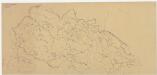
Gewässergebiete des Kantons Zürich; Situationspläne: Adlikon, Altikon, Berg, Buch, Dägerlen, Dättlikon, Dinhard, Dorf, Ellikon, Flaach, Freienstein, Andelfingen, Henggart, Hettlingen, Humlikon, Freienstein, Neftenbach, Unterembrach, Rickenbach, Rorbas, Seuzach, Thalheim an der Thur, Volken
1 : 2500 Mit Gemeindenummerierung. Ohne Datumsangabe.
Karte des Kantons Zürich: Blatt 2: Nordosten
1 : 33333
Wandkarte des Cantons Zürich
1 : 50000 Nordost-Blatt Keller, Heinrich Heinrich Keller
Schaffhauser Gebiet samt den Grentzen und umligenden Orten
1 : 50000 1 Karte auf 4 Bl. von Heinrich Peyer verfertigt 1685 [Verlag nicht ermittelbar], [Erscheinungsort nicht ermittelbar]
[Topographische Karte des Bezirks Winterthur]
1 : 50000 1 Karte
Topographische Karte des Bezirks Winterthur
1 : 50000 1 Karte [von Johannes] Randegger
Nova descriptio ditionis Tigurinae regionumque finitimarum
1 : 95000 1 Karte auf 6 Bl. Joh. Conradus Gygerus, P. delineavit ; Joh. Georgius Gygerus, F. in aes incidi ; curavit per Johannem Meyerum Ao. 1685
Nova descriptio ditionis Tigurinae regionumque finitimarum
1 : 95000 1 Karte auf 6 Bl. Joh. Conradus Gygerus, P. delineavit ; Joh. Georgius Gygerus, F. in aes incidi ; curavit per Johannem Meyerum Ao. 1685
Nr. 3: Militärquartier Winterthur; Übersichtskarte von 1660
Handgezeichnete Kopie der von Hans Conrad Gyger, andere Schreibweisen: Geiger, Geyger, (1599-1674), Kartograf, Ingenieur und Amtmann des Amts Kappelerhof, von Zürich, verfertigten Originalkarte. Ohne Datumsangabe. Spitteler, Sigmund (1732-1818), Ingenieur und Strassenbauinspektor des Kantons Zürich, von Läufelfingen BL und Hottingen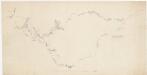
Winterthur bis Unterstammheim: Projektierte Strassen von Winterthur über a) Seuzach, Eschlikon, Thalheim an der Thur (damals Dorlikon), Burghof, Langmühle, Waltalingen und über b) Oberohringen, Hettlingen, Andelfingen, Kleinandelfingen, Ossingen, Gysenhard, Guntalingen bis Unterstammheim; Übersichts
Ohne Datumsangabe.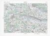
Landeskarte der Schweiz 1 : 25000: Den Kanton Zürich betreffende Blätter: Blatt 1052: Andelfingen
1 : 25000 Stand des Karteninhalts: 2014. Bundesamt für Landestopografie swisstopo, in Köniz-Wabern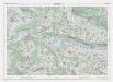
Landeskarte der Schweiz 1 : 25000: Den Kanton Zürich betreffende Blätter: Blatt 1052: Andelfingen
1 : 25000 Erstausgabe 1958; Nachführungen 1966, 1972, 1978, 1984, 1990, 1996, 2002. Bundesamt für Landestopografie swisstopo, in Köniz-Wabern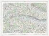
Landeskarte der Schweiz 1 : 25000: Den Kanton Zürich betreffende Blätter: Blatt 1052: Andelfingen
1 : 25000 Erstausgabe 1958; Nachführungen 1966, 1972, 1978, 1984, 1990, 1996. Bundesamt für Landestopographie, in Köniz-Wabern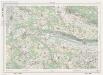
Landeskarte der Schweiz 1 : 25000: Den Kanton Zürich betreffende Blätter: Blatt 1052: Andelfingen
1 : 25000 Erstausgabe 1958; Nachführungen 1966, 1972, 1978, 1984. Bundesamt für Landestopographie, in Köniz-Wabern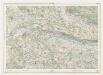
Landeskarte der Schweiz 1 : 25000: Den Kanton Zürich betreffende Blätter: Blatt 1052: Andelfingen
1 : 25000 Erstausgabe 1958. Eidgenössische Landestopographie, in Köniz-Wabern
Projektierte Eisenbahnstrecke Andelfingen-Singen; Übersichtskarte
1 : 50000 Mit Angabe der beiden Projekte. Ohne Datumsangabe. Wurster, Randegger und Cie., in Winterthur
Andelfingen
1 : 25000 1 Karte [Lithographie: Johann Jakob Brack]
Gewässergebiete des Kantons Zürich; Situationspläne: Benken, Dachsen, Flurlingen, Feuerthalen, Hüntwangen, Kleinandelfingen, Laufen, Marthalen, Oberstammheim, Ossingen, Rafz, Rheinau, Truttikon, Trüllikon, Unterstammheim, Waltalingen, Wasterkingen, Wil, Wilen
1 : 2500 Mit Gemeindenummerierung. Ohne Datumsangabe.
Winterthur
1 : 25000 1 Karte [Lithographie: Josef Graf]
Kanton Zürich: Wassernutzungskataster; Übersichtskarten: Bezirk Winterthur
1 : 25000 Ausgangskarten (zusammengesetzt): Ausschnitte der Blätter 27 (Eglisau), 41 (Bülach), 43 (Kloten), 54 (Hettlingen), 55 (Ellikon), 56 (Wiesendangen), 58 (Frauenfeld), 65 (Winterthur), 67 (Kyburg), 68 (Turbenthal), 69 (Aadorf), 71 (Bichelsee), 159 (Schwamendingen), 210 (Volketswil), 211 (Russikon) und 214 (Sternenberg) des Topographischen Atlasses der Schweiz (Siegfried-Karte). Ausgangskarten Leitung: Siegfried, Hermann (1819-1879), Topograf und Kartograf, von Zofingen AG; Eidgenössisches Topographisches Bureau, in Bern
Hans Konrad Gyger's Züricher-Cantons-Carte 1667
1 : 32000 1 Karte in 56 Teilen Hans Konrad Gyger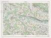
Landeskarte der Schweiz 1 : 25000: Den Kanton Zürich betreffende Blätter: Blatt 1052: Andelfingen
1 : 25000 Erstausgabe 1958; Nachführungen 1966, 1972, 1978, 1984, 1990. Bundesamt für Landestopographie, in Köniz-Wabern
Stammheim
1 : 25000 1 Karte [Lithographie: Johann Jakob Brack]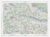
![[Region Winterthur-Schaffhausen]](https://images-1.georeferencer.com/images/iiif/329847841122/full/,300/0/native.jpg)

