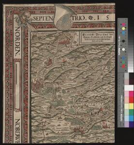
Maps of Schaffhausen

Eigentliche Verzeichnuss der Stätten, Graffschaften und Herrschaften, welche in der Statt Zürich Gebiet und Landschaft gehörig sind
1 : 56000 1 Karte auf 16 Bl. gerissen durch Josen Murern
[Eigentliche Verzeichnung der Städten, und Graffschaften, und Herrschaften, welche in der Stadt Zürich Gebiet und Landschaft gehörig sind]
1 : 56000 1 Karte auf 6 Bl. [gerissen durch Josen Murer]
[Region Winterthur-Schaffhausen]
1 : 120000 1 Karte Lith. v. C.G. Wenng
Nr. 2: Militärquartier Trüllikon; Übersichtskarte
1 : 43500 Originaltitel: Dess Trüllicker Quartiers, sampt den anstössen anderer Landschafften, vnd Quartieren, Eigentlicher Grundriss vnd gewüsse Verzeichnuss. Gyger, Hans Conrad, andere Schreibweisen: Geiger, Geyger, (1599-1674), Kartograf, Ingenieur und Amtmann des Amts Kappelerhof, von Zürich
a) Gemeinden im Thurgebiet: Abwasseranfall und Abwasserreinigung; Übersichtskarten b) Gemeinden im Reussgebiet: Abwasseranfall und Abwasserreinigung; Übersichtskarten
1 : 100000 Mit Angabe bestehender, im Bau befindlicher und projektierter Reinigungsanlagen sowie der massgebenden Einwohnerzahl (häuslicher und industrieller Anteil) pro Gemeinde.
Nr. 2: Militärquartier Trüllikon; Übersichtskarte von 1660
Handgezeichnete Kopie der von Hans Conrad Gyger, andere Schreibweisen: Geiger, Geyger, (1599-1674), Kartograf, Ingenieur und Amtmann des Amts Kappelerhof, von Zürich, verfertigten Originalkarte. Ohne Datumsangabe. Spitteler, Sigmund (1732-1818), Ingenieur und Strassenbauinspektor des Kantons Zürich, von Läufelfingen BL und Hottingen
Karte des Kantons Schaffhausen
1 : 80000 Gerster, Johann Sebastian C. Schoch's Buchhandlung
Kanton Zürich: Wassernutzungskataster; Übersichtskarten: Bezirk Andelfingen
1 : 25000 Ausgangskarten (zusammengesetzt): Ausschnitte der Blätter 16 (Schaffhausen), 25 (Rheinau), 27 (Eglisau), 41 (Bülach), 47 (Diessenhofen), 48 (Stein), 52 (Andelfingen), 53 (Stammheim), 54 (Hettlingen), 55 (Ellikon), 65 (Winterthur) und 66 (Wiesendangen) des Topographischen Atlasses der Schweiz (Siegfried-Karte). Ausgangskarten Leitung: Siegfried, Hermann (1819-1879), Topograf und Kartograf, von Zofingen AG; Eidgenössisches Topographisches Bureau, in Bern
Karte des Kantons Schaffhausen
1 : 80000 1 Karte von J. S. Gerster ; Lith. Hofer & Co., Zürich C. Schoch's Buchhandlung, Schaffhausen
Kanton Zürich: Wasserbenutzungsrechtkataster; Übersichtskarten: Bezirk Andelfingen
1 : 25000 Ausgangskarte: Blatt 53 (Stammheim) des Topographischen Atlasses der Schweiz (Siegfried-Karte). Ausgangskarten Leitung: Siegfried, Hermann (1819-1879), Topograf und Kartograf, von Zofingen AG; Eidgenössisches Topographisches Bureau, in Bern
[Region Winterthur-Schaffhausen]
1 : 120000 1 Karte Lith. v. C.G. Wenng
Ditionis pagi Scaphusiani, qui confoederatae Helvetiorum reipublicae pars est descriptio geographica nova studio adornata
1 : 90000 Mollova mapová sbírka Lotter, Tobias Conrad Seutter, Matthäus
Territorium reipublicæ liberæ helveticae Scaphvsiensis
1 Karte : Kupferdruck ; 23 x 25 cm Walser; Peyer Homännische Erben
Ditionis pagi Scaphusiani, qui confœderatæ Helvetiorum reipublicæ pars est descriptio geographica
1 Karte : Kupferdruck ; 48 x 55 cm Seutter; Lotter; Probst anjezo in Verlag bey Ioh. Mich. Probst Chalogr
Territorium reipublicae liberae helveticae Scaphvsiensis
1 Karte : Kupferdruck ; 40 x 53 cm Walser; Peyer Homännische Erben
Territorium reipublicae liberae helveticae Scaphvsiensis
1 Karte : Kupferdruck ; 40 x 53 cm Walser; Peyer Homännische Erben
Ditionis pagi Scaphusiani, qui confœderatæ Helvetiorum reipublicæ pars est descriptio geographica
1 Karte : Kupferdruck ; 48 x 56 cm Seutter; Lotter Matthäus Seutter
Schafthauser Gebiet samt den Grentzen und umbligende[n] Orten
1 : 58500 Schaffhausen (Švýcarsko : kanton) Peyer, Heinrich Mayer, F.
Gewässergebiete des Kantons Zürich; Situationspläne: Adlikon, Altikon, Berg, Buch, Dägerlen, Dättlikon, Dinhard, Dorf, Ellikon, Flaach, Freienstein, Andelfingen, Henggart, Hettlingen, Humlikon, Freienstein, Neftenbach, Unterembrach, Rickenbach, Rorbas, Seuzach, Thalheim an der Thur, Volken
1 : 2500 Mit Gemeindenummerierung. Ohne Datumsangabe.
Schaffhauser Gebiet samt den Grentzen und umligenden Orten
1 : 50000 1 Karte auf 4 Bl. von Heinrich Peyer verfertigt 1685 [Verlag nicht ermittelbar], [Erscheinungsort nicht ermittelbar]
Nova descriptio ditionis Tigurinae regionumque finitimarum
1 : 95000 1 Karte auf 6 Bl. Joh. Conradus Gygerus, P. delineavit ; Joh. Georgius Gygerus, F. in aes incidi ; curavit per Johannem Meyerum Ao. 1685
Nova descriptio ditionis Tigurinae regionumque finitimarum
1 : 95000 1 Karte auf 6 Bl. Joh. Conradus Gygerus, P. delineavit ; Joh. Georgius Gygerus, F. in aes incidi ; curavit per Johannem Meyerum Ao. 1685
Gewässergebiete des Kantons Zürich; Situationspläne: Benken, Dachsen, Flurlingen, Feuerthalen, Hüntwangen, Kleinandelfingen, Laufen, Marthalen, Oberstammheim, Ossingen, Rafz, Rheinau, Truttikon, Trüllikon, Unterstammheim, Waltalingen, Wasterkingen, Wil, Wilen
1 : 2500 Mit Gemeindenummerierung. Ohne Datumsangabe.
Feuerthalen bis Kaiserstuhl AG: Rhein; Grundriss
1 : 10000 Vergrössert aus der Topographischen Karte des Kantons Zürich (Wild-Karte). Ohne Datumsangabe.
Kanton Zürich: Staats-, Gemeinde- und Genossenschaftswaldungen: Blatt 2: Gegend zwischen Rafz und Truttikon sowie bei Benken und Laufen-Uhwiesen; Situationsplan
1 : 25000 Auf Ausgangskarten angebrachte farbige Eintragungen und Einzeichnungen. Ohne Erstellungsdatumsangabe. Ausgangskarten: Blätter 16 (Schaffhausen), 25 (Rheinau), 47 (Diessenhofen) und 52 (Andelfingen) des Topographischen Atlasses der Schweiz (Siegfried-Karte). Hartmann, Karl, Forstadjunkt im Zürcher Oberforstamt, von Aarau, in Unterstrass
Projektierte Eisenbahnstrecke Andelfingen-Singen; Übersichtskarte
1 : 50000 Mit Angabe der beiden Projekte. Ohne Datumsangabe. Wurster, Randegger und Cie., in Winterthur
Landeskarte der Schweiz 1 : 25000: Den Kanton Zürich betreffende Blätter: Blatt 1052: Andelfingen
1 : 25000 Stand des Karteninhalts: 2014. Bundesamt für Landestopografie swisstopo, in Köniz-Wabern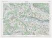
Landeskarte der Schweiz 1 : 25000: Den Kanton Zürich betreffende Blätter: Blatt 1052: Andelfingen
1 : 25000 Erstausgabe 1958; Nachführungen 1966, 1972, 1978, 1984, 1990, 1996, 2002. Bundesamt für Landestopografie swisstopo, in Köniz-Wabern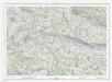
Landeskarte der Schweiz 1 : 25000: Den Kanton Zürich betreffende Blätter: Blatt 1052: Andelfingen
1 : 25000 Erstausgabe 1958; Nachführungen 1966, 1972, 1978, 1984, 1990, 1996. Bundesamt für Landestopographie, in Köniz-Wabern