Maps of Obwalden

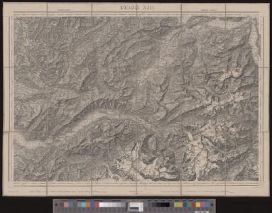
Topographische Karte der Schweiz
1 : 100000 25 Karten vermessen und hrsg. auf Befehl der Eidgenössischen Behörden ; aufgenommen unter der Aufsicht des Generals G.H. Dufour Eidg. Topographisches Bureau, [Genève], [später: Bern]
Interlaken, Sarnen, Stanz
1 : 100000 1 Karte bearbeitet von F.J. Kaufmann, A. Baltzer, C. Moesch [Wurster & Randegger], [Winterthur]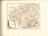
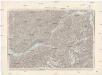
Interlaken, Sarnen, Stans
1 : 100000 Interlaken (Švýcarsko) Dufour, Henri Guillaume
Blatt XIII: Interlaken, Sarnen, Stanz, uit: Topographische Karte der Schweiz / vermessen und hrsg. ... unter Aufsicht des Generals G.H. Dufour
1 : 100000 Annotatie: Met plaatsnamenregister (bl. V), bladwijzer (bl. XXI) en hoogteregister (bl. XXV); Voor aanwezige bladen zie overzichtsblad Dufour, G. H. [Bern : Eidg. Topogr. Bureau]
Atlas novus Reipublicae Helveticae
1 Atlas ([40] Bl., 97 S.) bey Orell, Gessner und Compagnie, Zürich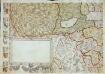
Inclitae Bernatum urbis, cum omni ditionis suae agro et provinciis delineatio chorographica, 7/8
2 Blätter : Adelbert Saueracher
Atlas der alten Eidgenossenschaft in 20 Karten: Kanton Unterwalden
Originaltitel: Canton Unterwalden sive Pagus Helvetiae Subsylvanus cum adjacentibus Terrarum Tractibus. Mit Erklärung der Zeichen. Zeichnung: Walser, Gabriel (1695-1776), reformierter Pfarrer, von Teufen AR Herausgeber: Homännische Erben
Canton Unterwalden sive pagus Helvetiae Subsilvanus cum adjacentibus terrarum tractibus
1 Karte : Kupferdruck ; 23 x 25 cm Walser Homännische Erben
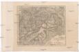
Die Canton Uri und Unterwalden
1 : 222000 Švýcarsko
Die Cantone Uri und Unterwalden
1 : 22800 Scheurmann, J.
Cantone Uri und Unterwalden
1 : 260000 Scheuermann, Johann Jakob Orell, Füssli & Cp.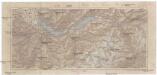
Berner Oberland
1 : 200000 Bern (Švýcarsko : kanton) Rüegg & Schaufelberger
Interlaken und Umgebung
1 : 50000 Hodler, Emil Im Selbstverlag des Verfassers
Relief pittoresque du sol classique de la Suisse
9 Karten dessiné d'après nature et gravé à l'eau forte par Frédéric Guillaume Delkeskamp ; terminé à l'aqua tinta par François Hegi et J.J. Sperli à Zuric = Malerisches Relief des klassischen Bodens der Schweiz / Nach der Natur gezeichnet und radirt von Friedrich Wilhelm Delkeskamp ; in Aqua tinta vollendet von Franz Hegi und J.J. Sperli in Zürich Friedrich Wilhelm Delkeskamp, Frankfurt a/M.
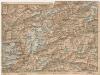
Taschen-Atlas der Schweiz
1 Atlas (25 S., 20 Taf.) gezeichnet und gestochen von Emil Wagner = Atlas de poche de la Suisse : 26 cartes en couleurs / dessinées et gravées par Émile Wagner Eggimann, Genf
Canton Unterwalden
1 : 125000 Bruder, Carl [Huber]
Canton Unterwalden sive Pagus Helvetiae Subsylvanus cum adjacentibus Terrarum Tractibus recenter delineatus
1 : 100000 Mollova mapová sbírka Walser, Gabriel Homann, Johann Baptista - dědici
Canton Unterwalden sive pagus Helvetiae Subsylvanus cum adjacentibus terrarum tractibus
1 Karte : Kupferdruck ; 45 x 51 cm Walser edentibus Homannianis Heredibus
Canton Unterwalden sive pagus Helvetiae Subsylvanus cum adjacentibus terrarum tractibus
1 Karte : Kupferdruck ; 45 x 51 cm Walser edentibus Homannianis Heredibus
Karte des Kantons Unterwalden
Businger, Josef Maria [Meyer]
Bez titulu: Alpy
Das Berner Oberland
Bern (Švýcarsko : kanton) Hoffmann, Karl Friedrich Vollrath Fleischmann, F. in der J.G. Cottaschen Buchhandlung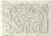
Geographica Provinciarum Sveviae Descriptio =
Mollova mapová sbírka Hurter, Johann Christoph Bodenehr, Johann Georg
[Kaart], uit: Berner Oberland und Oberwallis
1 : 75000 Annotatie: Deel van het blad ligt los Bern : Kümmerly & Frey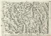
Geographica Provinciarum Sveviae Descriptio =
Mollova mapová sbírka Hurter, Johann Christoph Bodenehr, Gabriel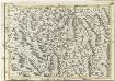
Die Gegend um Lucern
1 : 300000 Mollova mapová sbírka Bodenehr, Gabriel Bodenehr, Gabriel
Relief pittoresque du sol classique de la Suisse
9 Karten dessiné d'après nature et gravé à l'eau forte par Frédéric Guillaume Delkeskamp ; terminé à l'aqua tinta par François Hegi et J.J. Sperli à Zuric = Malerisches Relief des klassischen Bodens der Schweiz / Nach der Natur gezeichnet und radirt von Friedrich Wilhelm Delkeskamp ; in Aqua tinta vollendet von Franz Hegi und J.J. Sperli in Zürich Friedrich Wilhelm Delkeskamp, Frankfurt a/M.
Taschen-Atlas der Schweiz
1 Atlas (25 S., 20 Taf.) gezeichnet und gestochen von Emil Wagner = Atlas de poche de la Suisse : 26 cartes en couleurs / dessinées et gravées par Émile Wagner Eggimann, Genf