Maps of Goms

Canton Unterwalden sive pagus Helvetiae Subsilvanus cum adjacentibus terrarum tractibus
1 Karte : Kupferdruck ; 23 x 25 cm Walser Homännische Erben
<<Die>> Cantone Uri und Unterwalden
1 : 260000 1 Karte gestochen von J. Scheurmann [Orell Füssli & Comp.], [Zürich]
<<Die>> Cantone Uri und Unterwalden
1 : 260000 1 Karte gestochen von J. Scheurmann Orell Füssli & Cp., Zürich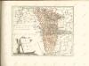

<<Die>> Cantone Uri und Unterwalden
1 : 260000 1 Karte gestochen von J. Scheurmann Orell, Füssli & Cp., Zürich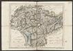
Cantone Uri und Unterwalden
1 : 260000 Scheuermann, Johann Jakob Orell, Füssli & Cp.
Interlaken, Sarnen, Stanz
1 : 100000 1 Karte bearbeitet von F.J. Kaufmann, A. Baltzer, C. Moesch [Wurster & Randegger], [Winterthur]
Die Cantone Uri und Unterwalden
1 : 22800 Scheurmann, J.
Taschen-Atlas der Schweiz
1 Atlas (25 S., 20 Taf.) gezeichnet und gestochen von Emil Wagner = Atlas de poche de la Suisse : 26 cartes en couleurs / dessinées et gravées par Émile Wagner Eggimann, Genf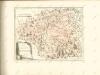

Die Canton Uri und Unterwalden
1 : 222000 Švýcarsko
St. Gotthard
1 Vogelschaukarte Art. Institut Orell Füssli, Zürich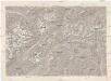
Gotthard
1 : 100000 Eidgenössische Landestopographie
Topographische Karte der Schweiz
1 : 100000 25 Karten vermessen und hrsg. auf Befehl der Eidgenössischen Behörden ; aufgenommen unter der Aufsicht des Generals G.H. Dufour Eidg. Topographisches Bureau, [Genève], [später: Bern]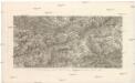
St. Gotthard Gebirge, Theil des Berner Oberlandes und das obere Rhone Thal
Rýn, řeka-tok horní Delkeskamp, F. W. Dauch, J. Ph.
Relief pittoresque du sol classique de la Suisse
9 Karten dessiné d'après nature et gravé à l'eau forte par Frédéric Guillaume Delkeskamp ; terminé à l'aqua tinta par François Hegi et J.J. Sperli à Zuric = Malerisches Relief des klassischen Bodens der Schweiz / Nach der Natur gezeichnet und radirt von Friedrich Wilhelm Delkeskamp ; in Aqua tinta vollendet von Franz Hegi und J.J. Sperli in Zürich Friedrich Wilhelm Delkeskamp, Frankfurt a/M.
Canton Unterwalden
1 : 125000 Bruder, Carl [Huber]
Karte des Kantons Unterwalden
Businger, Josef Maria [Meyer]
Relief pittoresque du sol classique de la Suisse
9 Karten dessiné d'après nature et gravé à l'eau forte par Frédéric Guillaume Delkeskamp ; terminé à l'aqua tinta par François Hegi et J.J. Sperli à Zuric = Malerisches Relief des klassischen Bodens der Schweiz / Nach der Natur gezeichnet und radirt von Friedrich Wilhelm Delkeskamp ; in Aqua tinta vollendet von Franz Hegi und J.J. Sperli in Zürich Friedrich Wilhelm Delkeskamp, Frankfurt a/M.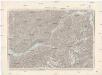
Interlaken, Sarnen, Stans
1 : 100000 Interlaken (Švýcarsko) Dufour, Henri Guillaume
Blatt XIII: Interlaken, Sarnen, Stanz, uit: Topographische Karte der Schweiz / vermessen und hrsg. ... unter Aufsicht des Generals G.H. Dufour
1 : 100000 Annotatie: Met plaatsnamenregister (bl. V), bladwijzer (bl. XXI) en hoogteregister (bl. XXV); Voor aanwezige bladen zie overzichtsblad Dufour, G. H. [Bern : Eidg. Topogr. Bureau]
Canton Uri
1 : 100000 Müllhaupt, Hans Heinrich Eidg. Stabsbureau
Karte eines Theiles von Unterwalden und Uri
Leuzinger, Rudolf R. Leuzinger
Canton Unterwalden sive Pagus Helvetiae Subsylvanus cum adjacentibus Terrarum Tractibus recenter delineatus
1 : 100000 Mollova mapová sbírka Walser, Gabriel Homann, Johann Baptista - dědici
Canton Unterwalden sive pagus Helvetiae Subsylvanus cum adjacentibus terrarum tractibus
1 Karte : Kupferdruck ; 45 x 51 cm Walser edentibus Homannianis Heredibus
Canton Unterwalden sive pagus Helvetiae Subsylvanus cum adjacentibus terrarum tractibus
1 Karte : Kupferdruck ; 45 x 51 cm Walser edentibus Homannianis Heredibus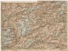
[Andermatt und Umgebung]
1 : 250000 Alpy švýcarské (pohoří) Wagner & Debes
Rigi und Urner See
Geologischer Atlas zur Naturgeschichte der Erde Leonhard, Carl Cäsar von E. Schweizerbart'sche Verlagsbuchhandlung
Canton Uri sive pagus Helvetiae Uriensis cum subditis suis in Valle Lepontina
1 Karte : Kupferdruck ; 45 x 54 cm Walser; Dorn edentibus Homannianis Heredibus


