Maps of Ozaukee County

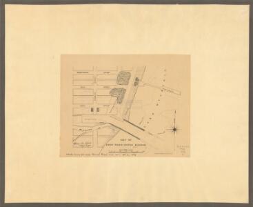
Map of Port Washington harbor / Henry M. Robert.
1 : 2400 This map shows existing and proposed harbor improvements, streets, Sauk River, and Lake Michigan. On the bottom of the map inscribed in ink is: "44th Cong., 2d sess., House Exec. Doc. no. 1, pt. 2, 1876". Robert, Henry M. Am. Photo-lithographic Co.
Port Washington East
1 : 24000
Port Washington East
1 : 24000
Port Washington East
1 : 24000
Port Washington East
1 : 24000
Port Washington
1 : 62500
Port Washington
1 : 62500
Port Washington
1 : 62500
Port Washington
1 : 62500
Map of Washington and Ozaukee counties, State of Wisconsin.
1 : 126720 Snyder, Van Vechten & Co.
Milwaukee
1 : 100000
Section 2. Bicycle Road Map of Wisconsin.
1 : 253440 League of American Wheelmen, Wisconsin Division
Milwaukee
1 : 250000
Milwaukee
1 : 250000
Milwaukee
1 : 250000
Milwaukee
1 : 250000
Map of Racine and Kenosha counties, State of Wisconsin.
1 : 126720 Snyder, Van Vechten & Co.
Wisconsin S. part.
1 : 780000 Morse, Sidney E. (Sidney Edwards), 1794-1871
Triangulation in Wisconsin
1 : 506880 This map shows names of triangulation stations, railroads, counties, rivers, and lakes. The Mississippi River, Lake Winnebago, and Lake Michigan are labeled. The upper right corner includes a key of markings. The map covers north to Eau Claire. Davies, John Eugene Wisconsin Geological Survey
Educational map of the state of Wisconsin
1 : 380160 This map is ink on paper and shows the location of various types of schools. The map includes text about the school system and tables of statistics (1849-1875) including: Number of children-attendance -- Apportionment of state money -- School houses -- Annual expenses -- Teachers and certificates -- Teachers' wages -- Territorial divisions -- Statistics for 1875 -- Statistics of cities. The map also includes illustrations of: River Falls Normal School -- Oshkosh Normal School -- Platteville Normal School -- University of Wisconsin (Ladies Hall, S. Dormitory, University Hall, N. Dormitory) -- Science Hall (University of Wisconsin) -- Whitewater Normal School. Searing, Edward
A Geological Map of Wisconsin
1 : 1710720 This map shows counties, cities, rivers, canals, lakes, railroads, common roads, county towns, townships, villages, and post offices. The map includes part of the upper peninsula of Michigan. Lapham, Increase Allen
Wisconsin.
1 : 1340000 Mitchell, Samuel Augustus
Shell Highway Map of Wisconsin (northern portion).
1 : 950400 Shell Oil Company
208. Illinois. The World Atlas.
1 : 1250000 USSR (Union of Soviet Socialist Republics).
Iowa And Wisconsin.
1 : 1600000 Goodrich, S.G.
Iowa and Wisconsin.
1 : 1600000 Bradford, Thomas G.
Wisconsin.
1 : 1030000 Rand McNally and Company
Wisconsin.
1 : 2100000 Rand McNally and Company
Climatological map of Wisconsin.
1 : 1520640 Snyder, Van Vechten & Co.
Map of the State of Wisconsin.
1 : 1140480 Snyder, Van Vechten & Co.
State of Wisconsin.
1 : 760320 U.S. General Land Office
Geological map of Wisconsin.
1 : 1520640 Snyder, Van Vechten & Co.
Map of Wisconsin showing congressional and judicial districts.
1 : 1520640 Snyder, Van Vechten & Co.
Map of Wisconsin showing senatorial districts.
1 : 1520640 Snyder, Van Vechten & Co.
Map of Wisconsin, showing assembly districts.
1 : 1520640 Snyder, Van Vechten & Co.
Wisconsin.
1 : 1330560 Cram Atlas Company
Wisconsin.
1 : 1140480 U.S. General Land Office